Belmont (CDP), New Hampshire facts for kids
Quick facts for kids
Belmont, New Hampshire
|
|
|---|---|

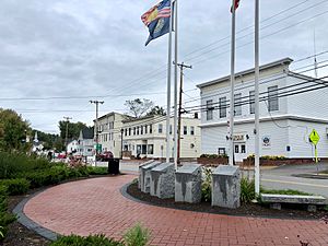
Main Street in Belmont
|
|
| Country | United States |
| State | New Hampshire |
| County | Belknap |
| Town | Belmont |
| Area | |
| • Total | 1.27 sq mi (3.30 km2) |
| • Land | 1.26 sq mi (3.26 km2) |
| • Water | 0.01 sq mi (0.04 km2) |
| Elevation | 528 ft (161 m) |
| Population
(2020)
|
|
| • Total | 1,285 |
| • Density | 1,021.46/sq mi (394.45/km2) |
| Time zone | UTC-5 (Eastern (EST)) |
| • Summer (DST) | UTC-4 (EDT) |
| ZIP code |
03220
|
| Area code(s) | 603 |
| FIPS code | 33-04660 |
| GNIS feature ID | 2629713 |
Belmont is a special kind of community called a census-designated place (CDP). It's the main village within the larger town of Belmont in Belknap County, New Hampshire, United States. In 2020, about 1,285 people lived in the Belmont CDP. The entire town of Belmont had a population of 7,314 people.
Contents
Where is Belmont Located?
The Belmont CDP is in the southern part of the town. It sits along a section of the Tioga River. This part of the river drops about 40 feet over just 0.4 miles.
The CDP area stretches out in different directions. It goes southwest to Pumping Station Brook and south to Wareing Road. To the east, it includes Belmont Elementary School. It also extends north to Perkins Road and River Street.
How to Get Around Belmont?
Two main roads, Route 106 and Route 140, meet in Belmont. These roads help people travel to other towns.
- Route 106 goes north about 6 miles to Laconia.
- Route 106 also goes south about 16 miles to Concord.
- Route 140 heads east about 16 miles to Alton.
- Route 140 goes west about 5 miles to Tilton.
What is the Size of Belmont?
The Belmont CDP covers a total area of about 3.3 square kilometers (1.27 square miles). Most of this area is land. Only a small part, about 0.04 square kilometers (0.01 square miles), is water.
Who Lives in Belmont?
| Historical population | |||
|---|---|---|---|
| Census | Pop. | %± | |
| 2010 | 1,301 | — | |
| 2020 | 1,285 | −1.2% | |
| U.S. Decennial Census | |||
In 2010, there were 1,301 people living in the Belmont CDP. These people lived in 515 households. A household is a group of people living together in one home.
What are the Age Groups in Belmont?
The people living in Belmont are of all ages.
- About 26.7% of residents were under 18 years old.
- About 13.6% were 65 years old or older.
- The average age of people in Belmont was about 36.1 years.
See also
 In Spanish: Belmont (condado de Belknap) para niños
 | DeHart Hubbard |
 | Wilma Rudolph |
 | Jesse Owens |
 | Jackie Joyner-Kersee |
 | Major Taylor |


