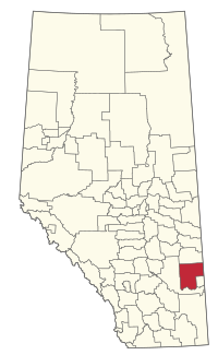
Special Area No. 3 facts for kids
Quick facts for kids
Special Area No. 3
|
|
|---|---|

Location within Alberta
|
|
| Country | Canada |
| Province | Alberta |
| Planning region | Red Deer |
| Incorporated | April 7, 1959 |
| Area
(2021)
|
|
| • Land | 6,469.33 km2 (2,497.82 sq mi) |
| Population
(2021)
|
|
| • Total | 1,142 |
| • Density | 0.2/km2 (0.5/sq mi) |
| Time zone | UTC-7 (MST) |
| • Summer (DST) | UTC-6 (MDT) |
| Postal Code Prefix |
T0J
|
| Area code | +1-403 |
| Website | Special Areas Board |
Special Area No. 3 is a unique part of southern Alberta, Canada. It is like a rural county or municipal district. However, it is managed a bit differently. A group called the Special Areas Board helps oversee the area. This board has four people chosen by the province to guide the area.
A large body of water, the Blood Indian Creek Reservoir, is also found within Special Area No. 3.
Contents
Geography of Special Area No. 3
Special Area No. 3 is a large rural region. It covers a wide area of land in southern Alberta.
Towns and Villages
Several communities are located within or surrounded by Special Area No. 3. These places are important for the people who live there.
The following towns are surrounded by Special Area No. 3:
The following villages are surrounded by Special Area No. 3:
Hamlets and Localities
Many smaller communities, known as hamlets and localities, are found across Special Area No. 3. These are often small groups of homes or former settlements.
The following hamlets are located within Special Area No. 3:
The following localities are located within Special Area No. 3:
- Anatole
- Big Stone
- Cabin Lake
- Calthorpe
- Cappon
- Dobson
- Gold Spur
- Helmsdale
- Naco
- Sunnydale
- Wastina
Population and People
Special Area No. 3 is a large area with a smaller number of people living in it. This means it has a very low population density.
Population in 2021
In the 2021 Census, 1,142 people lived in Special Area No. 3. These people lived in 439 homes. This number was a small change from the population in 2016. The land area is about 6,469 square kilometers. This means there were only about 0.2 people per square kilometer.
Population in 2016
In the 2016 Census, the population was 1,042 people. They lived in 387 homes. The land area was about 6,625 square kilometers.

