Bere Island facts for kids
|
Native name:
an tOileán Mór
Oiléan Béarra |
|
|---|---|

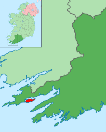
A map of Bere Island within Ireland
|
|
|
The location of Bere Island in Ireland
|
|
| Geography | |
| Location | Bantry Bay |
| Coordinates | 51°38′N 9°53′W / 51.633°N 9.883°W |
| Area | 17.68 km2 (6.83 sq mi) |
| Length | 10.1 km (6.28 mi) |
| Width | 2.9 km (1.8 mi) |
| Highest elevation | 270 m (890 ft) |
| Highest point | Knockanallig |
| Administration | |
| County | County Cork |
| Largest settlement | Rerrin |
| Demographics | |
| Population | 167 (2016) |
| Ethnic groups | Irish |
Bere Island (also called Oiléan Béarra, meaning "bear island", or officially An tOileán Mór, meaning "the big island") is a beautiful island off the Beara Peninsula in County Cork, Ireland. It is about 10 kilometers long and 3 kilometers wide. The island covers an area of 17.68 square kilometers. In 2012, around 210 to 220 people lived there.
An old legend says the island was named by a king from long ago. In the 2nd century, Mogh Nuadat, a king of Munster, named it after his wife, Beara. She was the daughter of Heber Mór, the King of Castile.
Contents
Discovering Bere Island's Past
Bere Island has a long and interesting history. People have lived here for thousands of years.
Ancient Times and Early Settlements
- Old Tombs and Stones: You can still find signs of early humans on the island. These include huge stone tombs called megalithic tombs. There are also tall, upright stones known as standing stones.
- O'Sullivan Bere Clan: For a long time, the island belonged to the O'Sullivan Bere family. They were powerful Irish chieftains. Their rule ended in 1602.
- First Military Interest: The island first became important for military reasons in 1602. An English leader, Sir George Carew, ordered a road built across the island. This helped his soldiers reach the Siege of Dunboy.
French Fleets and British Forts
- French Invasion Attempt (1796): In December 1796, a French fleet sailed into Bantry Bay. They were led by General Hoche and Wolfe Tone, an Irish rebel leader. Strong winds stopped the main French force from landing. The fleet eventually had to go home. A French boat that did land on Bere Island is now in the National Museum of Ireland.
- British Defenses: After this, the British government worried about more invasions. In 1803, during the Napoleonic Wars with France, they decided to strengthen defenses.
- Martello Towers: Lieutenant-Colonel William Twiss was sent to plan defenses for Bantry Bay. To protect British ships, four round stone towers called Martello Towers were built on Bere Island. They were ready by 1805. These towers helped guard the harbor between the island and the mainland.
- Other Buildings: Besides the towers, a signal tower, a barracks for soldiers, a quay (dock), and storehouses were also built.
- More Fortifications (1898): Later, in 1898, the British military took over more land on the island. They built even more forts to protect their large fleet in Berehaven Harbour.
Modern History and Treaty Ports
- Irish War of Independence: During the Anglo-Irish War, some Irish rebels were held on Bere Island.
- Treaty Ports (1922-1938): In 1922, after the war, Ireland gained independence. However, the British kept control of three important deep-water ports. These were called Treaty Ports. Berehaven (on Bere Island) was one of them. The British used these as naval bases until 1938.
Exploring Ancient and Historic Sites
Bere Island is full of interesting old places to explore.
Archaeological Discoveries
- Ancient Settlements: You can find traces of very old homes and communities. These include a circular wall (at Greenane), a hut site (Ardaragh West), and a ringfort (at Cloonaghlin West).
- Burial Sites: There's also a collapsed wedge tomb (Ardaragh West) and another standing stone (at Greenane).
Military Remains
- Fortifications: The island's military past is clear to see. You can find the remains of old artillery batteries (at Ardaragh West, Cloonaghlin West).
- Martello Towers: The Martello Towers (at Ardaragh West, Cloonaghlin West) are still there.
- Communication Posts: There are also ruins of a telegraph station and a signal tower (at Derrycreeveen).
Shipwrecks
- Bardini Reefer: Just north of the island, you can find the wreckage of a ship called the Bardini Reefer. It sank on December 12, 1982, after burning for several days.
Bere Island's Geography
Let's look at where Bere Island is and what it's like.
Island Location
- Where it is: Bere Island sits between Berehaven Harbour and Bantry Bay. It's in the western part of County Cork. The island is about 1.5 kilometers from the town of Castletownbere.
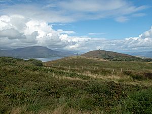
- Highest Point: The tallest spot on the island is Knockanallig, which is 270 meters high.
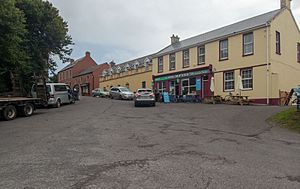
- Main Village: The main village is Rerrin (Raerainn), located towards the eastern end of the island. The main harbor, Lawrence Cove, is also nearby.
- Church and Graveyard: The island's church and its graveyard are in a place called Ballinakilla.
Island Areas
Bere Island is divided into smaller areas called townlands. Ten of these townlands are on the island. They include:
- Ardra West
- Ardra East
- Ballinakilla (where the church and a pub are)
- Cloonaghlin West
- Cloonaghlin Upper
- Cloonaghlin Lower
- Derrycreeveen
- Greenane
- Ardagh
- Rerrin
Life on Bere Island: Infrastructure and People
Getting Around the Island
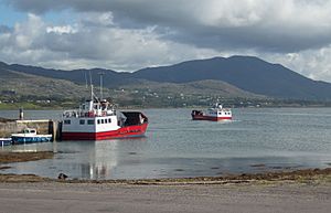
- Ferry Services: Two ferries connect the island to the mainland. Both can carry small vehicles.
- One ferry goes between Castletownbere and the west side of the island.
- The other ferry travels between Pontoon (a pier near Castletownbere) and Rerrin village.
- COVID-19 Changes: During the COVID-19 pandemic, ferry services were limited. Only residents could travel to help keep the virus off the island.
Power and Communication
- Electricity: Bere Island got mains electricity through an underwater cable. Work started in 1957 and finished in 1958.
- Local Radio: The island even has its own local radio station! It broadcasts for a few hours on Sundays on 100.1 MHz FM.
Who Lives on Bere Island?
- Population Changes: In 2012, about 200 people lived on Bere Island. However, in the past, many more people lived there.
- The Great Famine: In 1841, the population was 2,122. But by 1851, it had dropped to 1,454. This was due to the Great Famine, which caused many people to leave or die.
- Emigration: Like many parts of Ireland, the population continued to drop throughout the 1800s and 1900s as people moved away.
- Language: Unlike some other Irish islands, most people on Bere Island speak English. However, some islanders did speak Irish in 1911.
| Historical population | ||||||||||||||||||||||||||||||||||||||||||||||||||||||||||||||||||||||||||||||||||||||
|---|---|---|---|---|---|---|---|---|---|---|---|---|---|---|---|---|---|---|---|---|---|---|---|---|---|---|---|---|---|---|---|---|---|---|---|---|---|---|---|---|---|---|---|---|---|---|---|---|---|---|---|---|---|---|---|---|---|---|---|---|---|---|---|---|---|---|---|---|---|---|---|---|---|---|---|---|---|---|---|---|---|---|---|---|---|---|
|
|
|
||||||||||||||||||||||||||||||||||||||||||||||||||||||||||||||||||||||||||||||||||||
| Source: | ||||||||||||||||||||||||||||||||||||||||||||||||||||||||||||||||||||||||||||||||||||||
 | James B. Knighten |
 | Azellia White |
 | Willa Brown |


