
Bernville, Pennsylvania facts for kids
Quick facts for kids
Bernville, Pennsylvania
Bannwill
|
|
|---|---|

Eagle Hotel in Bernville, Pennsylvania
|
|

Location of Bernville in Berks County, Pennsylvania
|
|

Bernville, Pennsylvania
Location in Pennsylvania

Bernville, Pennsylvania
Location in the United States
|
|
| Country | United States |
| State | Pennsylvania |
| County | Berks |
| School District | Tulpehocken |
| Borough | 1851 |
| Area | |
| • Total | 0.43 sq mi (1.12 km2) |
| • Land | 0.42 sq mi (1.10 km2) |
| • Water | 0.01 sq mi (0.02 km2) |
| Elevation | 328 ft (100 m) |
| Population
(2020)
|
|
| • Total | 905 |
| • Density | 2,129.41/sq mi (823.00/km2) |
| Time zone | UTC-5 (EST) |
| • Summer (DST) | UTC-4 (EDT) |
| ZIP Code |
19506
|
| Area code(s) | 610 |
| FIPS code | 42-05848 |
Bernville (which is Bannwill in Pennsylvania Dutch) is a small town called a borough in Berks County, Pennsylvania, United States. In 2020, about 905 people lived there. Bernville is surrounded by Penn Township on three sides and Jefferson Township on the west.
Contents
History of Bernville
Early Settlers and the Town's Beginning
Long ago, the Lenape people lived in the Tulpehocken Creek valley. In 1723, about 33 German families from Schoharie, New York, moved to this area. They settled near where the Tulpehocken and Northkill Creeks meet. By 1735, there was already a mill for sawing wood and grinding grain nearby.
In 1737, a man named Stephanus Umbenhauer came from Bern, Switzerland. He bought a large piece of land, about 220 acres (0.89 km²). Later, in 1819, his grandson, Johann Thomas Umbenhauer, set aside 46 acres (190,000 m²) to create 62 building lots. The first six lots were bought by Peter Bennethum on August 24, 1819. In January 1820, the new town was named Bernville, honoring Stephanus's hometown in Switzerland. The very first house was built by Philip Filbert in 1820.
The Union Canal and Bernville's Growth
In 1828, the Union Canal was finished. This canal was a big deal because it connected the Susquehanna and Schuylkill rivers. A special part of the canal, called guard lock #36 and Lock #36, was built near Bernville. This lock helped boats move up or down the canal by 5 feet (1.5 m).
An old sign on Route 183 tells us more. It says the canal followed the north side of the Tulpehocken Creek. There was a dam, two locks, and a bridge for mules to cross Northkill Creek. Nearby, there were also mills, a lime kiln, and a tannery. Because of its location on the canal, Bernville became a busy and successful port town.
Becoming a Borough and Later Changes
By 1851, the people of Bernville were not happy with how their roads and services were managed by Penn Township. So, they decided to form their own local government. Bernville officially became a borough. This new borough included the original 62 lots.
However, in 1884, the Union Canal closed down. Since Bernville no longer had the canal or a railroad, its growth slowed down. In 1950, Bernville Borough expanded its borders by adding land from Penn Township at both ends of Main Street.
Geography of Bernville
Bernville is located at coordinates 40°26′1″N 76°6′40″W. The U.S. Census Bureau says the borough covers about 0.43 square miles (1.1 km²). A small part of this area, about 0.01 square miles (0.02 km²), is water. The border between Bernville and Jefferson Township is mostly formed by Northkill Creek.
Buildings and Landmarks

Main Street in Bernville was planned in 1819. Many buildings on this street are very old, dating back to the 1800s. These include the Cyrus G. Blatt home, the Eagle Hotel, and the Joseph B. Conrad home. Main Street is also where you'll find both of the town's churches. St. Thomas's UCC and Evangelical Lutheran Friedens Church are located across the street from each other.
-
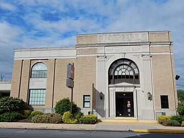
BB&T Bank
-
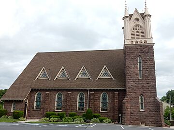
Evangelical Lutheran Friedens Church
-
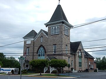
St. Thomas Church
-
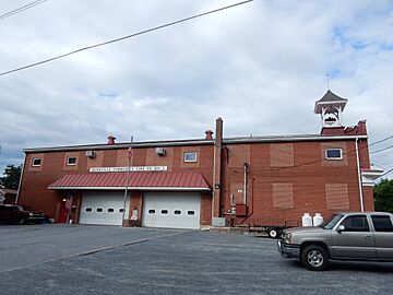
Bernville Community Fire Co. No. 1


Population and People
| Historical population | |||
|---|---|---|---|
| Census | Pop. | %± | |
| 1870 | 457 | — | |
| 1880 | 405 | −11.4% | |
| 1890 | 365 | −9.9% | |
| 1900 | 344 | −5.8% | |
| 1910 | 308 | −10.5% | |
| 1920 | 302 | −1.9% | |
| 1930 | 322 | 6.6% | |
| 1940 | 339 | 5.3% | |
| 1950 | 363 | 7.1% | |
| 1960 | 884 | 143.5% | |
| 1970 | 848 | −4.1% | |
| 1980 | 798 | −5.9% | |
| 1990 | 789 | −1.1% | |
| 2000 | 865 | 9.6% | |
| 2010 | 955 | 10.4% | |
| 2020 | 905 | −5.2% | |
| Sources: | |||
In 2000, there were 865 people living in Bernville. These people lived in 351 households, and 249 of these were families. The population density was about 2,122 people per square mile (820/km²). Most of the people (98.03%) were White. A small number were African American or from other races. About 1.39% of the population was Hispanic or Latino.
About 31.6% of households had children under 18. More than half (54.7%) were married couples. The average household had 2.46 people, and the average family had 2.85 people.
The population had a mix of ages. About 25.2% were under 18. The median age was 36 years old. This means half the people were younger than 36 and half were older.
The average income for a household in Bernville was $41,250. For families, the average income was $47,031. About 8.2% of the people lived below the poverty line.
Parks and Recreation
Bernville has two parks for everyone to enjoy. Umbenhauer Park, on Umbenhauer Drive, has a baseball field, a playground for younger kids, and a pavilion. Stanton Clay Park, located at Third Street and Penn Valley Road, has a gazebo and a small open field.
Northkill Creek flows into Blue Marsh Lake. Part of Bernville is actually within the Blue Marsh system. Blue Marsh Lake is a popular place for fun activities like hiking, boating, and fishing. The lake is also important for providing water, controlling floods, and protecting wildlife. A special wall along Northkill Creek helps protect Bernville from floods from Blue Marsh Lake.
Bernville also used to have a place called Blue Marsh Ski Resort. But it closed down in 2005.
Education in Bernville
The Tulpehocken Area School District serves the students of Bernville. Penn-Bernville Elementary School is located just outside the borough.
Transportation and Roads
_at_Second_Street_in_Bernville,_Berks_County,_Pennsylvania.jpg)
As of 2020, Bernville had about 5.92 miles (9.53 km) of public roads. The Pennsylvania Department of Transportation (PennDOT) takes care of 1.15 miles (1.85 km) of these roads. The borough itself maintains the other 4.77 miles (7.68 km).
Pennsylvania Route 183 is the main highway that goes through Bernville. It runs along Bernville Road on the southwest side of town. This road was originally planned for a railroad that was never built. Main Street runs next to PA 183, two blocks away. It goes through the middle of the original borough.
In the past, two covered bridges crossed Northkill Creek, connecting Bernville to Jefferson Township. The Northkill Covered Bridge was there from 1848 to about 1950. The South Bernville Covered Bridge existed from 1849 to 1938.
Images for kids
-
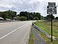
PA 183 southbound in Bernville
See also
 In Spanish: Bernville para niños
