Berrian Mountain facts for kids
Quick facts for kids Berrian Mountain |
|
|---|---|

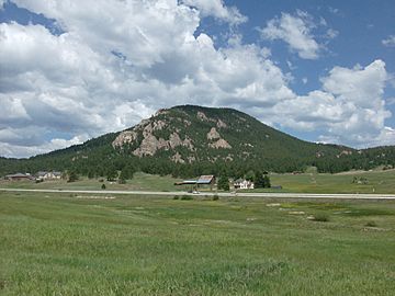
Berrian Mountain seen from Meyer Ranch Park.
|
|
| Highest point | |
| Elevation | 9,151 ft (2,789 m) |
| Prominence | 927 ft (283 m) |
| Isolation | 4.90 mi (7.89 km) |
| Geography | |
| Location | Jefferson County, Colorado, U.S. |
| Parent range | Front Range |
| Topo map | USGS 7.5' topographic map Conifer, Colorado |
| Climbing | |
| First ascent | 1879 |
| Easiest route | North-western face across Denver Mountain Parks open space |
Berrian Mountain is a tall mountain peak in the Front Range of the Rocky Mountains in North America. This mountain is about 9,151-foot (2,789 m) (or 2,789 meters) high. It is located in Jefferson County, Colorado, United States, not far from the town of Aspen Park.
About Berrian Mountain
Berrian Mountain is a part of the famous Rocky Mountains. It stands out in the landscape of Jefferson County, Colorado. It's a great place for outdoor activities and offers amazing views.
How Berrian Mountain Got Its Name
Have you ever wondered how mountains get their names? Berrian Mountain was named after a family! The Jefferson County Archives tell us it was named for the Berrian family. George, Dan, and Ray Berrian moved to Colorado from Kansas in 1887.
Before that, the mountain might have been called McIntyre Mountain. This name would have come from Duncan McIntyre. He owned land on the east side of the mountain.
A Small Shake-Up
On November 1, 1981, something interesting happened near Berrian Mountain. At 8:03 p.m. MST, a small earthquake occurred. It was a magnitude 3.1 tremor. This means it was not a very strong earthquake, but people in the area likely felt a slight shake.
 | Misty Copeland |
 | Raven Wilkinson |
 | Debra Austin |
 | Aesha Ash |


