
Bethel Park, Pennsylvania facts for kids
Quick facts for kids
Bethel Park, Pennsylvania
|
|||
|---|---|---|---|
|
Borough
|
|||
_2.jpg)
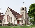
Bethel Presbyterian Church, the community's namesake
|
|||
|
|||

Location in Allegheny County and the U.S. state of Pennsylvania
|
|||
| Country | |||
| State | |||
| County | Allegheny | ||
| Founded (as Bethel Township) | 1886 | ||
| Incorporated | 1949 (borough) | ||
| Government | |||
| • Type | Council | ||
| Area | |||
| • Total | 11.70 sq mi (30.31 km2) | ||
| • Land | 11.70 sq mi (30.31 km2) | ||
| • Water | 0.00 sq mi (0.00 km2) | ||
| Elevation | 1,197 ft (365 m) | ||
| Population
(2020)
|
|||
| • Total | 33,577 | ||
| • Density | 2,869.34/sq mi (1,107.85/km2) | ||
| Time zone | UTC-5 (Eastern (EST)) | ||
| • Summer (DST) | UTC-4 (EDT) | ||
| ZIP Code |
15102, 15234, 15236, 15241
|
||
| Area code(s) | 412 | ||
| FIPS code | 42-06064 | ||


Bethel Park is a town in Allegheny County, Pennsylvania, United States. It's a suburb located about 7 miles (11 km) south of Pittsburgh. In 2020, about 33,577 people lived there. Bethel Park is known for its friendly neighborhoods and good schools. It's a great place to live and grow up!
Contents
History of Bethel Park

The area where Bethel Park is today was first settled around the year 1800. It became known as Bethel Township in 1886. The name comes from the Bethel Presbyterian Church. This church was named after an ancient place called Bethel in Israel. Bethel Park officially became a "borough" (a type of town) on March 17, 1949.
An interesting event happened in Bethel Park on March 11, 1927. It was the first time an armored car was robbed in the United States! A truck carrying money for a mine was attacked. The robbers used dynamite to block the road and steal the mining payroll.
Geography of Bethel Park
Bethel Park covers an area of about 11.7 square miles (30.3 square kilometers). It's located in a hilly region. The average height above sea level is about 1,197 feet (365 meters). The highest point in Bethel Park is Rocky Ridge, which is 1,370 feet (418 meters) high. The lowest point is 980 feet (299 meters) where two creeks meet.
Neighboring Towns
Bethel Park shares its borders with several other towns:
- To the north: Castle Shannon and Whitehall
- To the northeast: Baldwin
- To the east and southeast: South Park
- To the south: Peters Township
- To the west: Upper St. Clair
- To the north-northwest: Mt. Lebanon
Rocks and Mines
The rocks you can see in Bethel Park are mostly made of sandstone, limestone, shale, and layers of coal. These rocks formed a very long time ago, about 300 million years ago! Back then, the area was sometimes covered by a shallow sea or had rivers and deltas. Over time, these layers of mud, sand, and plant material turned into the rocks we see today.
Underneath Bethel Park, there are old coal mines. One of these was the Coverdale Mine, which opened around 1920. Miners used a method called "room and pillar" mining to dig out the coal. This means they left pillars of coal to support the mine roof. The Coverdale Mine is now closed.
People of Bethel Park
| Historical population | |||
|---|---|---|---|
| Census | Pop. | %± | |
| 1950 | 11,324 | — | |
| 1960 | 23,650 | 108.8% | |
| 1970 | 34,758 | 47.0% | |
| 1980 | 34,755 | 0.0% | |
| 1990 | 33,823 | −2.7% | |
| 2000 | 33,556 | −0.8% | |
| 2010 | 32,313 | −3.7% | |
| 2020 | 33,577 | 3.9% | |
| Sources: | |||
In 2020, about 33,577 people lived in Bethel Park. The town has grown a lot since the 1950s! Most families in Bethel Park are married couples with children. The average age of people living here is about 42 years old.
Arts and Culture
Bethel Park has a few interesting places to visit:
- Bethel Presbyterian Church: This historic church is where the town gets its name.
- South Hills Village: A large shopping mall where you can find many stores and places to eat.
Education in Bethel Park
Students in Bethel Park attend schools in the Bethel Park School District. The main high school for the district is Bethel Park High School.
Getting Around Bethel Park

Bethel Park is well-connected by public transportation. In the early 1900s, streetcar lines were built, which helped the town grow. Even though many streetcar lines in the Pittsburgh area closed down, the ones in Bethel Park stayed open and were updated to modern light rail lines in the 1980s.
Today, all three of Port Authority of Allegheny County's light rail lines run through Bethel Park. These lines make it easy for people to travel to Pittsburgh and other nearby areas. There are also "park-and-ride" lots where commuters can leave their cars and take the train.
Major roads like Pennsylvania Route 88 and U.S. Route 19 also pass through Bethel Park. Many shops and businesses are located along these roads. Bus services are also available to help people get around.
Famous People from Bethel Park
Many talented people have lived in Bethel Park, including:
- Terry K. Amthor, a game designer
- Barbara Feldon, an actress
- Armen Gilliam, a basketball player
- Scott Hahn, a Catholic theologian
- Nick Kwiatkoski, an American football player
- Mason Miller, a baseball player
- Steve Moakler, a musician
- Weird Paul Petroskey, a musician and YouTube personality
- Steve Previs, a basketball player
- Rick Sebak, a TV producer
- Joe Serafini, an actor
- Tom Skladany, an American football player
- Mike Westhoff, an American football coach
- Richard White, an actor
- Brian Young, a drummer and music producer
Images for kids
-
Bethel Presbyterian Church, the community's namesake
-
Flag of Bethel Park
-
Seal of Bethel Park
-

Location in Allegheny County and the U.S. state of Pennsylvania
See also
 In Spanish: Bethel Park para niños
