Bethlehem (CDP), New Hampshire facts for kids
Quick facts for kids
Bethlehem, New Hampshire
|
|
|---|---|

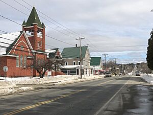
Center of Bethlehem, March 2024
|
|
| Country | United States |
| State | New Hampshire |
| County | Grafton |
| Town | Bethlehem |
| Area | |
| • Total | 1.64 sq mi (4.24 km2) |
| • Land | 1.63 sq mi (4.23 km2) |
| • Water | 0.00 sq mi (0.01 km2) |
| Elevation | 1,426.5 ft (434.8 m) |
| Population
(2020)
|
|
| • Total | 826 |
| • Density | 505.51/sq mi (195.15/km2) |
| Time zone | UTC-5 (Eastern (EST)) |
| • Summer (DST) | UTC-4 (EDT) |
| ZIP code |
03574
|
| Area code(s) | 603 |
| FIPS code | 33-05380 |
| GNIS feature ID | 2629715 |
Bethlehem is a small, charming village located in the beautiful state of New Hampshire, in the United States. It is part of Grafton County. This village is also known as a census-designated place (CDP).
In 2020, about 826 people lived in the Bethlehem village area. The larger town of Bethlehem had a total population of 2,484 people.
Geography of Bethlehem
Bethlehem village is found in the western part of the larger town of Bethlehem. It sits along U.S. Route 302. This area is at the northern base of Mount Agassiz, which is about 722 meters (2,370 feet) tall.
U.S. Route 302 is an important road here. If you travel east on this road, you will reach Twin Mountain in about 8 miles (13 km). If you go west, you will get to Littleton in about 5 miles (8 km).
Another road, New Hampshire Route 142, crosses U.S. Route 302 right in the middle of Bethlehem. Going north on Route 142 will take you to Whitefield in about 8 miles (13 km). Heading south on Route 142 leads to Franconia village, about 6 miles (10 km) away.
The Bethlehem village area covers about 4.2 square kilometers (1.6 square miles). Most of this area is land, with a very small part being water.
People of Bethlehem
The number of people living in Bethlehem village has changed over time.
| Historical population | |||
|---|---|---|---|
| Census | Pop. | %± | |
| 2010 | 972 | — | |
| 2020 | 826 | −15.0% | |
| U.S. Decennial Census | |||
In 2010, there were 972 people living here. By 2020, the population was 826.
In 2010, there were 424 households in Bethlehem. A household is a group of people living together in one home. About 33.5% of these households had children under 18 years old. Many households were married couples living together.
The average age of people in Bethlehem in 2010 was about 39.8 years old. This means half the people were younger than 39.8, and half were older.
See also
 In Spanish: Bethlehem (condado de Grafton) para niños
 | Charles R. Drew |
 | Benjamin Banneker |
 | Jane C. Wright |
 | Roger Arliner Young |


