
Betsie River facts for kids
Quick facts for kids Betsie River |
|
|---|---|

Betsie River Wetland Delta near Elberta, Michigan
|
|
| Physical characteristics | |
| Main source | Green Lake near Interlochen 44°35′31″N 85°47′41″W / 44.592082°N 85.794709°W |
| River mouth | Lake Michigan at Frankfort 44°37′46″N 85°14′46″W / 44.629532°N 85.246214°W |
| Length | 54 mi (87 km) |
The Betsie River is a lovely stream in the northwest part of Michigan. It flows for about 54 miles (87 km). The river's name comes from a French phrase. It means "river of sawbill ducks." These ducks have a saw-like bill.
The Betsie River flows mostly through Benzie County. This county is even named after the river! The river starts in Grand Traverse County. It also flows briefly through Manistee County. The Betsie River widens to form Betsie Lake. Then it empties into Lake Michigan between Frankfort and Elberta. The Betsie River is part of Michigan's Natural Rivers Program. This program helps protect the river.
Contents
Where the Betsie River Flows

The Betsie River starts from Green Lake. This lake is in Grand Traverse County. Other nearby lakes also drain into Green Lake. These include Duck Lake and its smaller streams.
From Green Lake, the river winds southwest. It goes into eastern Benzie County. Then it briefly enters northern Manistee County. After that, it turns north again into Benzie County. A dam on the river creates Homestead Pond. From there, the river flows mostly west. It eventually reaches Lake Michigan.
Betsie River's Water Area
The Betsie River collects water from a large area. This area is called its drainage basin. It covers about 155,026 acres (627 km²) in three counties. The river system includes about 93 miles (150 km) of streams. About 52 miles (84 km) of this is the main river itself.
Dams on the Betsie River
Dams are structures built across a river. They can control water flow or create ponds.
- Homestead Dam: Most of this dam was removed in 1974. Now, it mainly acts as a barrier for lamprey. Lamprey are fish that can harm other fish. This dam does not stop salmon from migrating upstream. The remains of the dam are sometimes called "Homestead Falls."
- Grass Lake Dam: This dam is about 4 miles (6 km) downstream from Green Lake. It creates a pond of about 90 acres (36 ha). The dam was built in 1951. Its purpose was to improve habitats for waterfowl (like ducks) and northern pike fish.
- Thompsonville Dam: This was an old power dam. It broke in 1989 and was removed. Before it was removed, it blocked salmon from swimming upstream. Now, salmon and trout can swim freely along the entire main river. They can even go above the Grass Lake Dam.
Streams Joining the Betsie River
Many smaller streams and lakes flow into the Betsie River. These are called tributaries.
- Betsie Lake
- Crystal Lake Outlet
- Crystal Lake
- Cold Creek
- Crystal Lake
- Rice Creek
- Dair Creek
- Little Betsie River
- Pickerel Creek
- Twin Lake
- Upper Twin Lake
- Grass Lake
- Mud Lake
- Green Lake
- Bridge Lake
- Tullers Lake
- Cedar Hedge Lake
- Mud Lake
- Duck Lake
- Horton Creek
- Brigham Creek
- Mason Creek
- Weidenhamer Swamp
- Tonawanda Lake
- Ellis Lake
* Saunders Lake
Images for kids
-
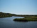
Betsie River Wetland Delta near Elberta, Michigan
-
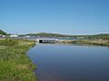
Betsie River emptying into Betsie Lake, Elberta, MI (bridge shown is M-22 crossing the river outlet)
-
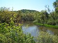
Betsie River east of Elberta, MI
-
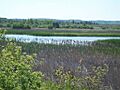
Betsie River wetland near Elberta, MI


