
Elberta, Michigan facts for kids
Quick facts for kids
Elberta, Michigan
|
|
|---|---|
|
Village
|
|
.jpg)
Lake Michigan from Elberta Bluffs
|
|
,_MI_location.png)
Location within Benzie County
|
|

Elberta, Michigan
Location in Michigan
|
|
| Country | |
| State | |
| County | Benzie |
| Township | Gilmore |
| Area | |
| • Total | 1.01 sq mi (2.61 km2) |
| • Land | 0.75 sq mi (1.94 km2) |
| • Water | 0.26 sq mi (0.68 km2) |
| Elevation | 591 ft (180 m) |
| Population
(2020)
|
|
| • Total | 329 |
| • Density | 439.25/sq mi (169.66/km2) |
| Time zone | UTC-5 (Eastern (EST)) |
| • Summer (DST) | UTC-4 (EDT) |
| ZIP code(s) |
49628
|
| Area code(s) | 231 |
| FIPS code | 26-25180 |
| GNIS feature ID | 0625422 |
Elberta is a small village in Benzie County, located in the U.S. state of Michigan. In 2020, about 329 people lived there. Elberta is part of Northern Michigan. It sits in Gilmore Township, with views of Lake Michigan. The village is also across Betsie Lake from the town of Frankfort.
Contents
History of Elberta Village
Elberta was first settled in 1855. It became an official village in 1894 and was first called South Frankfort. The village got its current name, Elberta, in 1911. This name came from a type of local fruit, the Elberta peach. George M. Cartwright is believed to be the founder of the village.
A short state highway, M-168, used to run through Elberta. It connected to M-22 and led to the old Ann Arbor Railroad ferry docks. This highway was removed in 2012.
What is Elberta's Geography Like?
According to the United States Census Bureau, Elberta covers about 0.99 square miles (2.6 square kilometers). Most of this area, about 0.74 square miles (1.9 square kilometers), is land. The rest, about 0.25 square miles (0.65 square kilometers), is water. The center of the village is located at 44°37′10″N 86°13′35″W. Elberta is considered part of Northern Michigan.
Main Roads in Elberta
- M-22 is a major road that goes through Elberta. It runs north and south, following the coast of Lake Michigan. You can use M-22 to get to Frankfort.
- M-168 was a shorter road that used to be in Elberta. It connected M-22 to the old Ann Arbor Railroad ferry docks. This road was officially closed in 2012.
How Did People Travel by Ferry and Rail?
From the 1890s until July 1950, the Ann Arbor Railroad ran ferries from docks in Elberta. These ferries crossed Lake Michigan to two different places in Wisconsin. There was also a fourth ferry line that went north to Gladstone, Michigan in the Michigan Upper Peninsula.
During the same time, the Ann Arbor Railroad also operated a train every day. This train traveled south from Elberta to places like Cadillac, Owosso, Durand, and Ann Arbor, ending its journey in Toledo, Ohio.
How Many People Live in Elberta?
| Historical population | |||
|---|---|---|---|
| Census | Pop. | %± | |
| 1900 | 639 | — | |
| 1910 | 681 | 6.6% | |
| 1920 | 588 | −13.7% | |
| 1930 | 609 | 3.6% | |
| 1940 | 617 | 1.3% | |
| 1950 | 850 | 37.8% | |
| 1960 | 552 | −35.1% | |
| 1970 | 542 | −1.8% | |
| 1980 | 556 | 2.6% | |
| 1990 | 478 | −14.0% | |
| 2000 | 457 | −4.4% | |
| 2010 | 372 | −18.6% | |
| 2020 | 329 | −11.6% | |
| U.S. Decennial Census | |||
What Was the Population in 2010?
Based on the 2010 census, 372 people lived in Elberta. There were 173 households and 101 families. The village had about 502.7 people per square mile (194.1 people per square kilometer). There were 229 houses, with about 309.5 houses per square mile (119.5 houses per square kilometer).
Most of the people in Elberta were White (95.2%). A small number were African American (0.8%), Native American (0.8%), or Asian (0.3%). Some people (0.8%) were from other racial backgrounds, and 2.2% were from two or more races. About 3.5% of the population identified as Hispanic or Latino.
Out of 173 households, 22.5% had children under 18 living there. About 42.8% were married couples. Some households (8.1%) had a female head with no husband, and 7.5% had a male head with no wife. About 41.6% of households were not families. Many households (34.7%) had only one person living in them, and 13.8% had someone aged 65 or older living alone. The average household had 2.15 people, and the average family had 2.71 people.
The average age in the village was 47.8 years. About 18.5% of residents were under 18. About 7.5% were between 18 and 24. People aged 25 to 44 made up 19.2% of the population. Those aged 45 to 64 were 33.1%, and 21.5% were 65 or older. There were slightly more males (51.9%) than females (48.1%) in the village.
Images for kids
-
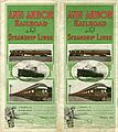
These Ann Arbor Railroad cars and steamships would have been familiar sights in Elberta in 1911, when this timetable was printed.

See also
 In Spanish: Elberta (Míchigan) para niños
