Frankfort, Michigan facts for kids
Quick facts for kids
Frankfort, Michigan
|
|
|---|---|
| City of Frankfort | |

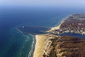
Aerial view of Frankfort Harbor
|
|

Location within Benzie County
|
|
| Country | |
| State | |
| County | Benzie |
| Established | 1850 |
| Incorporated | 1885 (village) 1935 (city) |
| Area | |
| • Total | 1.59 sq mi (4.11 km2) |
| • Land | 1.39 sq mi (3.60 km2) |
| • Water | 0.20 sq mi (0.51 km2) |
| Elevation | 633 ft (193 m) |
| Population
(2020)
|
|
| • Total | 1,252 |
| • Density | 900.72/sq mi (347.67/km2) |
| Time zone | UTC-5 (EST) |
| • Summer (DST) | UTC-4 (EDT) |
| ZIP code(s) |
49635
|
| Area code(s) | 231 |
| FIPS code | 26-30260 |
| GNIS feature ID | 0626407 |
Frankfort is a small city in the U.S. state of Michigan. It is located in Benzie County. The city sits right on the shore of Lake Michigan. It is also at the mouth of the Betsie River. In 2020, about 1,252 people lived in Frankfort.
Contents
History of Frankfort
Frankfort has a long and interesting history. Some historians believe that Father Jacques Marquette, an early explorer, might have died and been buried here in May 1675. His exact death site is still debated. However, his remains were later moved to St. Ignace.
The land that became Frankfort was seen as important for business early on. The Risdon family, who surveyed the land, bought most of it. The first known settler was Joseph Oliver. He bought land between Lake Aux Becs Scies and Lake Michigan in 1852. He built a small cabin and lived by fishing, hunting, and cutting timber.
In 1855, a ship called the Schooner found a safe harbor here during a storm. This led to an investor, George W. Tifft, buying over a thousand acres of land around the lake. In 1859, a company from Detroit bought Tifft's land. They started to develop Frankfort. They sent people like Louis A. Doby to manage the work. They also brought a sawmill. Doby worked to dig a new channel. This made the harbor open for all kinds of boats.
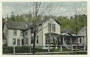
The first lot was sold to William H. Cogshall. He built a large home that also served as a hotel. It was used for religious and political meetings too. Dr. Alonzo J. Slyfield bought the second lot. He later worked as the keeper of the Point Betsie Lighthouse for 22 years.
Harbor Improvements
By 1867, the United States government saw how important Aux Becs Scies harbor was. They started making improvements. The channel was dredged again. Soon, many ships were arriving daily. New settlers came to the area. Stores were built, and a large hotel called the Delbridge House opened. A post office was also reopened in 1867.
Work on the harbor continued for several years. By 1870, the channel was 200 feet (61 m) wide. It had a south pier that was 600 feet (183 m) long. The north pier was 550 feet (168 m) long. The harbor was kept at a depth of about nine feet. This allowed most Great Lakes ships to enter.
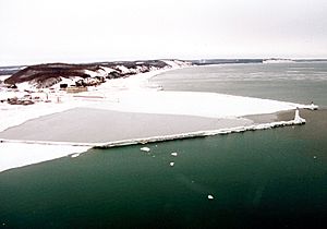
In 1873, the United States Lighthouse Service added the first pier head light. This light helped mark the entrance to the harbor. In 1887, a United States Life Saving Station was built. This station helped rescue people from shipwrecks. In 1934, it became part of the United States Coast Guard. The station moved to new buildings on the Frankfort side of the channel. The piers were extended to 2,000 feet (610 m) by 1912. Between 1929 and 1932, large breakwaters were built. These structures protect the harbor from big waves.
Becoming a Village and City
In 1859, Crystal Lake Township was formed. It included all of what is now Benzie County. The first township meeting was held in Frankfort in 1860. Frankfort was chosen as the county seat for Benzie County in 1870. This meant it was the main town for the county government. However, the county seat moved a few times. It finally moved to Honor in 1908.
In 1885, Frankfort officially became an incorporated village. This meant it had its own local government. Frankfort continued to grow steadily. By the 1930s, it had enough people to become a city. On March 11, 1935, the people of Frankfort voted to become a city. The boundaries of the city stayed the same as the village.
Geography and Climate
Frankfort covers a total area of 1.59 square miles (4.11 km2). Most of this area, 1.39 square miles (3.60 km2), is land. The rest, 0.20 square miles (0.51 km2), is water.
Frankfort is known as the entrance to the Sleeping Bear Dunes National Lakeshore. This is a beautiful area with large sand dunes. Frankfort is also considered part of Northern Michigan. The Point Betsie Light is nearby. This lighthouse has been helping ships for 150 years. It is now cared for by local groups. The town is also close to Interlochen State Park. This park has some of the last old-growth Eastern White Pine trees in the Lower Peninsula.
Local Climate
Frankfort has a "Warm Summer Continental Climate." This means it has warm summers and cold, snowy winters.
| Climate data for Frankfort 2 NE, Michigan (948 feet) 1991–2020 normals, extremes 1898–present | |||||||||||||
|---|---|---|---|---|---|---|---|---|---|---|---|---|---|
| Month | Jan | Feb | Mar | Apr | May | Jun | Jul | Aug | Sep | Oct | Nov | Dec | Year |
| Record high °F (°C) | 56 (13) |
63 (17) |
79 (26) |
86 (30) |
90 (32) |
95 (35) |
99 (37) |
95 (35) |
92 (33) |
84 (29) |
79 (26) |
62 (17) |
99 (37) |
| Mean daily maximum °F (°C) | 28.6 (−1.9) |
30.6 (−0.8) |
39.5 (4.2) |
51.8 (11.0) |
63.9 (17.7) |
73.4 (23.0) |
77.4 (25.2) |
76.1 (24.5) |
69.0 (20.6) |
56.2 (13.4) |
43.9 (6.6) |
33.6 (0.9) |
53.7 (12.1) |
| Daily mean °F (°C) | 23.6 (−4.7) |
24.8 (−4.0) |
32.5 (0.3) |
43.2 (6.2) |
54.4 (12.4) |
64.0 (17.8) |
68.9 (20.5) |
68.3 (20.2) |
61.4 (16.3) |
49.6 (9.8) |
38.4 (3.6) |
28.9 (−1.7) |
46.5 (8.1) |
| Mean daily minimum °F (°C) | 18.5 (−7.5) |
19.1 (−7.2) |
25.4 (−3.7) |
34.6 (1.4) |
44.9 (7.2) |
54.6 (12.6) |
60.4 (15.8) |
60.5 (15.8) |
53.9 (12.2) |
42.9 (6.1) |
32.9 (0.5) |
24.1 (−4.4) |
39.3 (4.1) |
| Record low °F (°C) | −20 (−29) |
−32 (−36) |
−15 (−26) |
−1 (−18) |
19 (−7) |
29 (−2) |
33 (1) |
31 (−1) |
26 (−3) |
18 (−8) |
−8 (−22) |
−4 (−20) |
−32 (−36) |
| Average precipitation inches (mm) | 2.19 (56) |
1.72 (44) |
1.98 (50) |
3.06 (78) |
3.08 (78) |
3.17 (81) |
3.04 (77) |
3.18 (81) |
3.75 (95) |
3.99 (101) |
2.94 (75) |
2.23 (57) |
34.34 (872) |
| Average snowfall inches (cm) | 27.2 (69) |
19.4 (49) |
12.8 (33) |
3.3 (8.4) |
0.1 (0.25) |
0.0 (0.0) |
0.0 (0.0) |
0.0 (0.0) |
0.0 (0.0) |
0.3 (0.76) |
6.4 (16) |
23.5 (60) |
93.0 (236) |
| Average precipitation days (≥ 0.01 in) | 15.2 | 11.2 | 9.3 | 10.1 | 10.7 | 9.2 | 9.2 | 8.6 | 10.6 | 13.0 | 12.4 | 13.2 | 132.7 |
| Average snowy days (≥ 0.1 in) | 14.2 | 10.4 | 6.2 | 1.9 | 0.1 | 0.0 | 0.0 | 0.0 | 0.0 | 0.2 | 4.3 | 11.4 | 48.7 |
| Source: NOAA | |||||||||||||
Population and People
| Historical population | |||
|---|---|---|---|
| Census | Pop. | %± | |
| 1880 | 782 | — | |
| 1890 | 1,175 | 50.3% | |
| 1900 | 1,465 | 24.7% | |
| 1910 | 1,555 | 6.1% | |
| 1920 | 1,244 | −20.0% | |
| 1930 | 1,468 | 18.0% | |
| 1940 | 1,642 | 11.9% | |
| 1950 | 1,605 | −2.3% | |
| 1960 | 1,690 | 5.3% | |
| 1970 | 1,660 | −1.8% | |
| 1980 | 1,603 | −3.4% | |
| 1990 | 1,546 | −3.6% | |
| 2000 | 1,513 | −2.1% | |
| 2010 | 1,286 | −15.0% | |
| 2020 | 1,252 | −2.6% | |
| U.S. Decennial Census | |||
Population in 2010
In 2010, Frankfort had 1,286 people living in 601 households. About 328 of these were families. The city had about 925 people per square mile (357/km2).
About 18% of households had children under 18. Many households (41.8%) were married couples. About 41.3% of all households were single people. Around 23.3% of households had someone aged 65 or older living alone. The average age in the city was 54.6 years. About 15.4% of residents were under 18. Many residents (36.1%) were 65 or older.
Economy and Activities
Frankfort is a popular place for tourists. It offers many fun things to do, both on the water and on land. Its location near rivers, lakes, and Lake Michigan makes it a great spot all year round. The city proudly advertises itself as a "four-season destination."
The New York Times has even suggested Frankfort as a great place to start a bike trip. Shopping and looking for antiques in the historic downtown area are also important for the local economy. Frankfort is also close to the Interlochen Center for the Arts. This is a famous school for young artists. It is also near Crystal Mountain (Michigan), a popular ski resort.
Transportation
- M-22 runs through Frankfort. It goes north and south, following the shore of Lake Michigan.
- M-115 starts just east of Frankfort. It goes east to other towns like Beulah and Cadillac. This highway can also connect you to US Highway 31.
 In Spanish: Frankfort (Míchigan) para niños
 | Bayard Rustin |
 | Jeannette Carter |
 | Jeremiah A. Brown |


