
Binnel Bay facts for kids
Quick facts for kids Binnel Bay |
|
|---|---|
 Binnel Bay looking southwest, with St. Catherine's Point in the distance |
|

Binnel Bay
|
|
| Civil parish |
|
| Ceremonial county | |
| Region | |
| Country | England |
| Sovereign state | United Kingdom |
| EU Parliament | South East England |
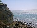
Binnel Bay is a beautiful bay on the south coast of the Isle of Wight, England. It's located between the villages of St. Lawrence and Niton. This bay faces south towards the English Channel. It's nearly one mile long. It stretches from Binnel Point in the east to Puckaster Cove in the west.
Binnel Bay is a quiet, remote spot. It has a rocky shoreline with low cliffs and trees behind it. You can get the best view from Binnel Point. From there, you can see the bay stretching towards Puckaster Cove. St Catherine's Lighthouse is also visible in the distance. You can still see parts of an old seawall from the 1800s along the shore. It's mostly destroyed now.
Contents
What is the Geology of Binnel Bay?
The coast here is part of something called the Undercliff landslide complex. This is a huge area where the land has slowly slid down towards the sea. It stretches along the south coast of the Isle of Wight. This area goes all the way from Bonchurch to Blackgang.
Because of these landslides, the cliffs and coastline at Binnel Bay are made from fallen rock and soil. This material comes from layers of Gault Clay and Upper Greensand rock. Beneath these fallen layers, you can find the original Lower Greensand rock.
The land above Binnel Bay is not very stable. It has had several landslides recently. A big landslide happened in March 2014. This event caused a section of the A3055 to be lost. The road called Undercliff Drive had to close. Several homes were also evacuated and left empty.
What is the History of Binnel Bay?
Scientists have found old items in the landslide areas at Binnel Bay. These items show that people lived here a very long time ago. Some findings date back to the neolithic period. This was around 2530 BC. They found charcoal and bones from animals like red squirrels and red deer. They also found shells from sea creatures.
Later discoveries include piles of waste from the Bronze Age and Iron Age. These tell us more about how people lived back then.
In 1977, a very old stone tool was found near Binnel Bay. It was a palaeolithic handaxe. This type of handaxe is called Acheulean. Experts think this tool might have come from higher ground. It probably moved into the landslide area later on.
Spindler's Folly: A Failed Harbour
In 1882, a German businessman named William Spindler had a big idea. He wanted to build a harbour and a holiday resort in St. Lawrence. He hoped it would be as popular as Ventnor to the east. However, he passed away before he could finish his project.
Spindler bought a large estate. This included a house that is now the Old Park Hotel. This house once belonged to Sir Richard Worsley, who was the island's governor. Spindler planned to build a town. He planted trees and laid out roads. His most notable project was building a large seawall at Binnel Bay.
The seawall was very strong. It was meant to let tourists reach St. Lawrence by sea. But the ground at Binnel Bay is very unstable. The seawall was built on active landslide areas made of Gault Clay. Because of this, it didn't have strong foundations.
Over time, the seawall fell apart. Landslides and severe winter storms destroyed it. The failed harbour became known as Spindler's Folly. Today, you can still see its broken pieces scattered around the bay.
Images for kids
-
The Cliff face at Binnel Bay

