Bird Island, South Georgia facts for kids
 |
|

South Georgia settlements
|
|
| Geography | |
|---|---|
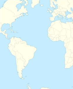
| Location | Atlantic Ocean |
| Coordinates | 54°0′20″S 38°3′0″W / 54.00556°S 38.05000°W |
| Highest elevation | 365 m (1,198 ft) |
| Highest point | Roché Peak |
| Administration | |
|
United Kingdom
|
|
| Overseas Territory | SGSSI |
| Additional information | |
| Time zone |
|
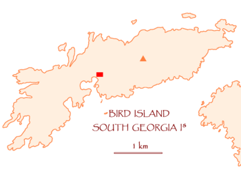
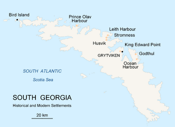
Bird Island (which means Isla Pájaro in Spanish) is a small island. It is about 4.8 kilometers (3 miles) long and 800 meters (half a mile) wide. It sits off the western end of South Georgia.
Bird Island is part of a British overseas territory called South Georgia and the South Sandwich Islands. However, Argentina also claims this area as part of its Tierra del Fuego province.
Contents
Bird Island: A Home for Wildlife
Discovering Bird Island
A British journey led by James Cook found Bird Island in 1775. Cook named it "Bird Island" because of the huge number of birds living there.
In the late 1950s, scientists started studying the island. They put rings on many wandering albatross birds. This helped them learn how far these birds travel. One albatross was even found all the way in Australia!
A Special Protected Place
Today, Bird Island is a Site of Special Scientific Interest. This means it's a very important place for nature. You need special permission to land on the island. This rule helps protect its unique wildlife.
Peaks and Pioneers
The highest point on the island is Roché Peak. It is named after Anthony de la Roché, an Englishman who found South Georgia in 1675. Farewell Point is the island's northeast tip.
The second highest peak is Tickell Peak, named after Lance Tickell. He was an Englishman who helped with the first science studies on Bird Island in 1958. He studied seals and albatrosses and was one of the first people to stay there through the winter.
Studying Nature at Bird Island
|
Bird Island
|
|
|---|---|
|
Antarctic base
|
|
| Country | United Kingdom |
| Territory | SGSSI |
| Operator | British Antarctic Survey |
| Established | 1957 |
| Population
(2018)
|
|
| • Summer | 10 |
| • Winter | 4 |
| UN/LOCODE | GS |
| Active times | All year-round |
| Status | Operational |
| Activities | Bird and seal research |
What Happens at the Research Station?
Bird Island has been a place for Antarctic research since 1963. It is now a special science station run by the British Antarctic Survey (BAS). This station is located at Jordan Cove.
Usually, three biologists and one technician live and work there. They mostly study the lives and numbers of the island's seabirds and seals.
Keeping the Station Safe
In 1982, during a conflict, many British people left Grytviken on South Georgia. But 15 Britons stayed safe on Bird Island. This meant the island and other British camps remained under British control.
Amazing Animals of Bird Island
Bird Island is home to an incredible amount of wildlife:
- 65,000 Antarctic fur seals. That's about one seal for every 6 square meters (65 square feet) of the island!
- 50,000 macaroni penguins.
- 15,000 pairs of black-browed albatross.
- 12,000 pairs of grey-headed albatross.
- 1,700 pairs of wandering albatross.
- 500 pairs of southern giant petrels. This is 10% of all the giant petrels on South Georgia.
Hundreds of thousands of other birds also live here. These include gentoo penguins, South Georgia pintails, and South Georgia pipits. Out of 31 types of birds that breed on South Georgia, 27 are found on Bird Island.
You can also see large sea animals like southern right whales. They come to these Subantarctic regions to feed.
A Rat-Free Paradise
Bird Island has always been free of rats. This is very important for the birds. The main island of South Georgia used to have rats, but they were removed between 2010 and 2015.
Bird Island's Weather
The weather on Bird Island can be quite cold and wet. Here is some information about its climate:
| Climate data for Bird Island, South Georgia, 1961–1990 | |||||||||||||
|---|---|---|---|---|---|---|---|---|---|---|---|---|---|
| Month | Jan | Feb | Mar | Apr | May | Jun | Jul | Aug | Sep | Oct | Nov | Dec | Year |
| Record high °C (°F) | 11.2 (52.2) |
10.7 (51.3) |
10.5 (50.9) |
10.2 (50.4) |
6.9 (44.4) |
6.0 (42.8) |
5.9 (42.6) |
4.8 (40.6) |
7.5 (45.5) |
10.4 (50.7) |
9.1 (48.4) |
9.4 (48.9) |
11.2 (52.2) |
| Mean daily maximum °C (°F) | 5.5 (41.9) |
5.6 (42.1) |
4.4 (39.9) |
1.9 (35.4) |
−0.5 (31.1) |
−1.8 (28.8) |
−2.4 (27.7) |
−1.9 (28.6) |
−0.2 (31.6) |
1.6 (34.9) |
3.4 (38.1) |
4.5 (40.1) |
1.7 (35.0) |
| Daily mean °C (°F) | 3.1 (37.6) |
3.5 (38.3) |
2.5 (36.5) |
0.4 (32.7) |
−2.1 (28.2) |
−3.2 (26.2) |
−3.9 (25.0) |
−3.3 (26.1) |
−1.8 (28.8) |
−0.2 (31.6) |
1.0 (33.8) |
2.0 (35.6) |
−0.2 (31.7) |
| Mean daily minimum °C (°F) | 0.7 (33.3) |
1.4 (34.5) |
0.6 (33.1) |
−1 (30) |
−3.8 (25.2) |
−4.6 (23.7) |
−5.4 (22.3) |
−4.8 (23.4) |
−3.4 (25.9) |
−1.9 (28.6) |
−1.5 (29.3) |
−0.6 (30.9) |
−2.0 (28.4) |
| Record low °C (°F) | −2 (28) |
−1.7 (28.9) |
−3.2 (26.2) |
−4.6 (23.7) |
−7.3 (18.9) |
−8.5 (16.7) |
−11.4 (11.5) |
−10.6 (12.9) |
−8.5 (16.7) |
−6.6 (20.1) |
−4.3 (24.3) |
−2.8 (27.0) |
−11.4 (11.5) |
| Average precipitation mm (inches) | 84 (3.3) |
80 (3.1) |
95 (3.7) |
123 (4.8) |
108 (4.3) |
108 (4.3) |
120 (4.7) |
114 (4.5) |
107 (4.2) |
98 (3.9) |
88 (3.5) |
77 (3.0) |
1,204 (47.4) |
| Source 1: Climatic Research Unit, UEA | |||||||||||||
| Source 2: Météo Climat | |||||||||||||
See also
 In Spanish: Isla Pájaro (Georgias del Sur) para niños
 | Charles R. Drew |
 | Benjamin Banneker |
 | Jane C. Wright |
 | Roger Arliner Young |


