
Black Diamond Mines Regional Preserve facts for kids
Quick facts for kids |
|
|
Black Diamond Mines
|
|
.JPG) |
|

Location in California

Location in the United States
|
|
| Nearest city | Antioch, California |
|---|---|
| NRHP reference No. | 91001425 |
| Added to NRHP | October 02, 1991 |
The Black Diamond Mines Regional Preserve is a huge park in Contra Costa County, California. It covers about 6,000 acres (2,400 hectares) and is managed by the East Bay Regional Park District. This special park protects the history of old mining towns and mines.
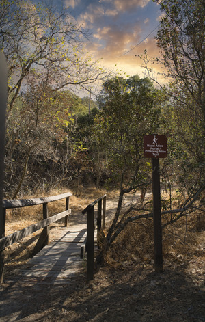
You can explore over 60 miles (97 km) of trails here. These trails wind through grassy hills, oak forests, and chaparral plants. The preserve also offers guided tours of a former sand mine, letting you step back in time!
Contents
History of the Black Diamond Mines
Early People of the Land
Long ago, about 13,000 years before mining began, Native American tribes lived in this area. Three Bay Miwok tribes—the Chupcan, Ompin, and Volvon—called this land home. The Chupcan lived to the west, the Volvon to the south, and the Ompin to the north.
In the early 1800s, Spanish missions greatly changed their lives. Many tribal members were moved to Mission Dolores or Mission San Jose. This marked a big shift in the history of these indigenous communities.
The Mount Diablo Coalfield Story

In 1859, William C. Israel found coal on his land. Soon, more coal was discovered, and mining quickly grew. This area became known as the Mount Diablo Coalfield. It was the biggest coalfield in California! Over time, it produced more than 400 million short tons (357 million long tons) of coal.
The preserve holds the remains of 12 coal mines and several old mining towns. These towns, like Nortonville, Somersville, and Stewartville, once bustled with people. Nortonville was the largest, with about 1,000 residents.
The coal found here was not the best quality, but it was the only easy-to-get source in California during the 1800s. It was super important for powering railroads, ships, and factories. People often called this valuable mineral "black diamond."
Miners used three railroads to carry the coal to the San Joaquin River. From there, barges shipped it to cities like San Francisco and Sacramento. Coal mining stopped when better, cheaper coal could be brought in, and when oil became a new energy source. The towns were then abandoned, and the land was used for cattle.
Today, the old coal mines are closed because they can be dangerous. Gases like carbon dioxide and methane can build up, and the rocks inside are unstable. Sadly, in 1980, four boys died from methane gas in an open mine. However, some mine entrances are now safe for visitors. You can look inside or even walk a short distance into places like Prospect Tunnel, which goes about 200 feet (61 meters) underground.
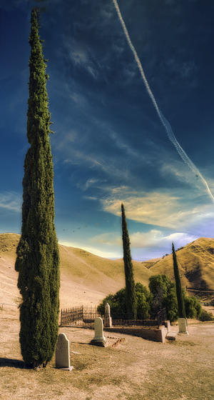
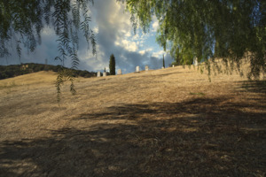
Rose Hill Cemetery: A Quiet Resting Place

Rose Hill Cemetery is a historic burial ground for over 200 people from the mining towns. It sits on a hillside between the old towns of Somersville and Nortonville. After the mines closed, the cemetery was forgotten for a while. Many gravestones were lost or damaged. In 1960, famous photographer Ansel Adams even took a picture of two trees there.
The land for the cemetery was given by Emma Rose, whose father was in charge of the Black Diamond Coal Mining Company. Sadly, the original records were lost in the 1906 San Francisco earthquake and fire.
Many graves here are unmarked or had wooden markers that disappeared over time. But we know a few stories:
- William Gething, 36, died in a mine explosion in 1876 with nine other men.
- Sarah Norton, 68, was a midwife who delivered over 600 babies for miners' wives. She died in an accident while on her way to deliver a baby.
- The oldest person known to be buried here was Ruth French, who passed away at 81 in 1874.
- The youngest was a one-day-old baby girl who died in 1880.
The Sandstone Mine

In the 1920s, a different kind of mine opened here. It produced high-quality silica sandstone. This sand was used by the Hazel-Atlas Glass Company in Oakland to make glass containers. Another sandstone mine provided sand for making steel at a mill in Pittsburg, California. These mines produced over 1.8 million short tons (1.6 million long tons) of sand!
The Hazel-Atlas mine is now a special museum. Park staff have worked hard to restore it. You can take guided tours to learn about the mine's history and the geology of the area.

Inside the Greathouse Portal, a 950-foot (290-meter) section of the mine entrance has become a museum. The first part has exhibits you can explore on your own. The second, larger part shows what the Hazel-Atlas works looked like around 1940. This museum closed for repairs in 2007 after a storm but reopened five years later.
Geology: How the Mines Were Formed
The coal and sandstone in Black Diamond Mines Regional Preserve were created millions of years ago. This happened during the Tertiary period, between the Paleocene and Miocene epochs. At that time, the North American and Pacific plates of the Earth's crust were moving together.
The Pacific Ocean once covered much of California's central valley. Over time, the land rose and fell, causing layers of ocean sediment to build up. The coal came from the third cycle of this process, during the middle of the Eocene epoch. Tectonic activity lifted the seafloor, creating shallow marshes. Plants grew thickly in these hot, humid marshes. When they died, they were buried by sediment and slowly turned into coal. Later, more tectonic activity created the Mount Diablo Mountain Range we see today.
Fun Things to Do and See
The trails at Black Diamond Mines offer amazing views! You can see Mount Diablo, the Sacramento-San Joaquin River Delta, and even the Sierra Nevada mountains on a clear day.
In spring, the preserve bursts with beautiful wildflowers. Keep an eye out for rare ones like the Mount Diablo fairy lantern and Mount Diablo sunflower. The park is also home to many animals, including deer, mountain lions, coyotes, foxes, and bobcats. You might even spot golden eagles and various hawks. Some endangered animals, like the San Joaquin kit fox and California red-legged frog, also live here.
The park is open all year for hiking, mountain biking, and horseback riding from 8 AM until dusk. You can even reserve a camp for an overnight stay. Some visitors have even reported seeing a ghost in the park!
New Land for the Park
On December 20, 2016, the East Bay Regional Park District received a gift of 50 acres (20 hectares) of land. This land was donated by Antioch Holdings LLC. The company's president, Gordon Grevelle, had planned to build homes there. But since the land was already surrounded by park property, he decided to donate it. This added even more space to the Black Diamond Mines Regional Preserve for everyone to enjoy.
See also
 In Spanish: Reserva Regional Minas Diamante Negro para niños
