Black Mountain South Top facts for kids
Quick facts for kids Black Mountain South Top |
|
|---|---|

|
|
| Highest point | |
| Elevation | 637 m (2,090 ft) |
| Prominence | 15 m (49 ft) |
| Parent peak | Black Mountain |
| Listing | Nuttall |
| Geography | |
| Location | Herefordshire, England / Powys, Wales |
| Parent range | Black Mountains |
| OS grid | SO255350 |
| Topo map | OS Landranger 161 |
| Climbing | |
| Easiest route | The Cat's back |
The Black Mountain South Top is a smaller peak that is part of the larger Black Mountain. This mountain is found in the Black Mountains range. This range stretches across parts of Powys and Monmouthshire in southeast Wales.
What makes Black Mountain South Top special is its location. It sits right on the border between Wales and England. This means it is partly in Powys, Wales, and partly in Herefordshire, England. A famous walking trail called the Offa's Dyke Path goes right over its highest point.
Exploring Black Mountain South Top
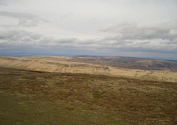
This peak is not a sharp, pointy mountain. Instead, it is a gently rounded hill covered in heather. The very top, called the summit, is marked by a small pile of stones. This pile of stones is often called a cairn. It helps hikers know they have reached the highest point.
Where is it Located?
Black Mountain South Top is found on a long, flat ridge called Hatterall Ridge. This ridge is part of the wider Black Mountains. These mountains are known for their rolling hills and beautiful views. They are a popular spot for hiking and enjoying nature.
How High is it?
The Black Mountain South Top reaches a height of 637 meters (about 2,090 feet) above sea level. While it is not the tallest mountain, it offers great views of the surrounding countryside.
What is a Nuttall?
Black Mountain South Top is listed as a "Nuttall." A Nuttall is a mountain in England or Wales that is at least 2,000 feet (610 meters) high. It must also have a drop of at least 15 meters (about 49 feet) on all sides. This means it stands out enough from other hills around it.
 | Sharif Bey |
 | Hale Woodruff |
 | Richmond Barthé |
 | Purvis Young |

