
Blackbutt, Queensland facts for kids
Quick facts for kids BlackbuttQueensland |
|||||||||||||||
|---|---|---|---|---|---|---|---|---|---|---|---|---|---|---|---|

Hotel Radnor
|
|||||||||||||||

Blackbutt
Location in Queensland
|
|||||||||||||||
| Population | 799 (2021 census) | ||||||||||||||
| • Density | 101.1/km2 (262/sq mi) | ||||||||||||||
| Established | 1887 | ||||||||||||||
| Postcode(s) | 4314 | ||||||||||||||
| Elevation | 474 m (1,555 ft) | ||||||||||||||
| Area | 7.9 km2 (3.1 sq mi) | ||||||||||||||
| Time zone | AEST (UTC+10:00) | ||||||||||||||
| Location | |||||||||||||||
| LGA(s) | South Burnett Region | ||||||||||||||
| County | Cavendish | ||||||||||||||
| Parish | Taromeo | ||||||||||||||
| State electorate(s) | Nanango | ||||||||||||||
| Federal Division(s) | Maranoa | ||||||||||||||
|
|||||||||||||||
Blackbutt is a small town in the South Burnett Region of Queensland, Australia. It is a rural area, meaning it's mostly countryside with farms. In 2021, about 799 people lived in Blackbutt.
Contents
Where is Blackbutt?
Blackbutt is located in the South Burnett Region of Queensland. It's about 166 kilometers (or 103 miles) north-west of Brisbane, which is the capital city of Queensland. The town is on the D'Aguilar Highway.
The town is also near Cooyar Creek. This creek flows into the Brisbane River, and it starts in the Bunya Mountains to the west.
A Look Back in Time
People from Europe first settled in the Blackbutt area in 1842. The Scott family started a large farm called Taromeo Station. In 1887, the Scott family gave land to create the towns of Blackbutt and nearby Benarkin.
More farms were set up in the area. When gold was found in the late 1800s, more people moved to Blackbutt, helping the town grow. Cutting down trees for wood (the timber industry) was also very important for the town's development.
The town gets its name from a tall tree called the 'blackbutt' tree (scientific name: Eucalyptus pilularis). This tree is common in south-eastern Australia and is known for its strong wood.
Blackbutt, Benarkin, and Yarraman are often called the "Timber Towns." You might see "Timbertown" in the names of local shops and sports teams.
Schools and Services
Blackbutt Provisional School first opened on January 20, 1896. It became Blackbutt State School in 1909. The school moved to its current, larger location in Blackbutt in January 1914.
The Blackbutt Post Office opened in November 1906, making it easier for people to send and receive mail. The Blackbutt Library opened in 1996, giving the community a place to read and learn.
The Twin Towns and the Rail Trail
When the railway station for Blackbutt was built, it was a bit far from the town. So, in 1910, they decided to name the station Benarkin instead. This led to a new town forming near the station, also called Benarkin. Because Blackbutt and Benarkin are only about 3.5 kilometers (2.2 miles) apart and have a shared history, they are often called the "twin towns."
Blackbutt was connected to the Brisbane Valley railway line in 1911. However, the train line closed in the 1980s. It was then turned into a rail trail, which is a path for walking, cycling, and horse riding.

The Blackbutt War Memorial was officially revealed on April 24, 1920. It honors those who served in wars.
Famous Connections
Tennis legend Roy Emerson was born on a farm near Blackbutt. He went to Nukku State School for his early education. The old school building now holds the Roy Emerson Museum in Blackbutt, celebrating his amazing tennis career.
How Many People Live Here?
In 2011, Blackbutt and Benarkin together had a population of 1,055 people. By 2016, Blackbutt alone had 836 people. In the most recent count in 2021, the population of Blackbutt was 799 people.
Getting Around and New Ideas
Blackbutt was the first place in Queensland where the government tried using a new material called "fibre composite" to build a bridge. This happened in 2005 for the Taromeo Creek bridge. Fibre composite materials are very strong, lighter than steel and concrete, and they don't rust!
Learning in Blackbutt
Blackbutt State School is a government primary school for students from Prep (the first year of school) to Year 6. It teaches both boys and girls. In 2017, the school had 165 students.
There isn't a high school directly in Blackbutt. Students usually go to nearby towns like Yarraman (which has a school for Prep to Year 9), Nanango, or Kingaroy for their secondary education.
What to Do in Blackbutt

The South Burnett Regional Council runs a public library in Blackbutt. It's a great place to find books and learn new things.
The Blackbutt Yarraman branch of the Queensland Country Women's Association (QCWA) meets at their hall. This group helps women in rural areas and supports the community.
Town Services
Blackbutt gets its water supply from Boobir Dam. This dam helps provide water for the town's needs.
Fun Events
Since 2016, Blackbutt has held the Blackbutt Avocado Festival every September. This festival celebrates avocados with cooking shows, avocado tossing games, and talks about growing avocados. It also has other fun activities like arts and crafts, woodchopping contests, and live music. Before this, it was known as the Bloomin Beautiful Blackbutt Festival.
Places to Visit
The Brisbane Valley Rail Trail goes right through Blackbutt. This trail is perfect for walking, cycling, and horse riding. No cars or motorbikes are allowed on it, making it a safe and enjoyable path.
The old Nukku school building was moved to Blackbutt to become the Roy Emerson Museum. Here, you can learn all about the famous tennis player Roy Emerson and his achievements.
Images for kids
-
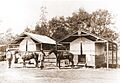
Blackbutt Police Station, 1912. Note the station badge attached to the peak of the right hand tent.
-
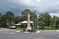
Blackbutt War Memorial, 2010
-
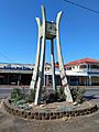
Dominating the main street is the distinctive mid-century modern (MCM) styled town clock.
