Blackduck, Minnesota facts for kids
Quick facts for kids
Blackduck
|
|
|---|---|

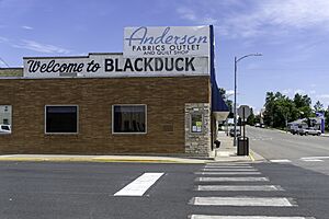
Downtown Blackduck
|
|
| Motto(s):
"A Great Place For Families"
|
|

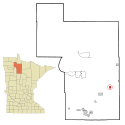
Location of Blackduck, Minnesota
|
|
| Country | United States |
| State | Minnesota |
| County | Beltrami |
| Incorporated (village) | October 19, 1900 |
| Incorporated (city) | December 21, 1900 |
| Area | |
| • Total | 1.59 sq mi (4.13 km2) |
| • Land | 1.55 sq mi (4.02 km2) |
| • Water | 0.04 sq mi (0.10 km2) |
| Elevation | 1,398 ft (426 m) |
| Population
(2020)
|
|
| • Total | 845 |
| • Estimate
(2021)
|
833 |
| • Density | 543.76/sq mi (209.94/km2) |
| Time zone | UTC-6 (CST) |
| • Summer (DST) | UTC-5 (CDT) |
| ZIP codes |
56630, 56663
|
| Area code(s) | 218 |
| FIPS code | 27-06256 |
| GNIS feature ID | 0655419 |
Blackduck is a small city in Beltrami County, Minnesota, United States. It is located about 24 kilometers (15 miles) northeast of Bemidji. In 2020, the city had a population of 845 people. Blackduck's motto is "A Great Place For Families."
Contents
History of Blackduck
The town of Blackduck was first settled because of the many trees in the area. These trees were perfect for logging. The first people to move here came from Crookston, Minnesota. Blackduck officially became a village on October 19, 1900. It then became a city a short time later, on December 21, 1900. The community got its name from the nearby Blackduck Lake. The land around Blackduck is good for logging because of the Laurentian Divide. This natural feature helps water drain away, keeping the land from being too wet.
Geography and Location
Blackduck covers an area of about 4.13 square kilometers (1.59 square miles). Most of this area is land, with a small part being water. The city is located in Beltrami County, Minnesota.
Climate in Blackduck
Blackduck experiences a climate with warm summers and very cold winters. You can see more details about the weather patterns below.
| Climate data for Blackduck, Minnesota, 1991–2020 normals, extremes 1989–2019 | |||||||||||||
|---|---|---|---|---|---|---|---|---|---|---|---|---|---|
| Month | Jan | Feb | Mar | Apr | May | Jun | Jul | Aug | Sep | Oct | Nov | Dec | Year |
| Record high °F (°C) | 52 (11) |
62 (17) |
71 (22) |
88 (31) |
90 (32) |
90 (32) |
95 (35) |
94 (34) |
89 (32) |
85 (29) |
69 (21) |
51 (11) |
95 (35) |
| Mean daily maximum °F (°C) | 18.0 (−7.8) |
23.7 (−4.6) |
36.9 (2.7) |
51.7 (10.9) |
64.7 (18.2) |
73.7 (23.2) |
78.3 (25.7) |
76.8 (24.9) |
67.6 (19.8) |
52.9 (11.6) |
36.4 (2.4) |
23.3 (−4.8) |
50.3 (10.2) |
| Daily mean °F (°C) | 4.7 (−15.2) |
9.6 (−12.4) |
23.2 (−4.9) |
38.1 (3.4) |
51.4 (10.8) |
61.3 (16.3) |
65.9 (18.8) |
63.9 (17.7) |
54.8 (12.7) |
41.7 (5.4) |
26.1 (−3.3) |
12.0 (−11.1) |
37.7 (3.2) |
| Mean daily minimum °F (°C) | −8.7 (−22.6) |
−4.5 (−20.3) |
9.5 (−12.5) |
24.6 (−4.1) |
38.1 (3.4) |
48.9 (9.4) |
53.5 (11.9) |
50.9 (10.5) |
42.1 (5.6) |
30.5 (−0.8) |
15.9 (−8.9) |
0.7 (−17.4) |
25.1 (−3.8) |
| Record low °F (°C) | −45 (−43) |
−44 (−42) |
−35 (−37) |
−20 (−29) |
20 (−7) |
30 (−1) |
37 (3) |
27 (−3) |
16 (−9) |
7 (−14) |
−28 (−33) |
−38 (−39) |
−45 (−43) |
| Average precipitation inches (mm) | 0.18 (4.6) |
0.37 (9.4) |
0.65 (17) |
1.16 (29) |
2.91 (74) |
4.30 (109) |
3.26 (83) |
2.80 (71) |
2.84 (72) |
2.69 (68) |
0.78 (20) |
0.31 (7.9) |
22.25 (564.9) |
| Average snowfall inches (cm) | 9.1 (23) |
10.1 (26) |
7.4 (19) |
7.1 (18) |
0.1 (0.25) |
0.0 (0.0) |
0.0 (0.0) |
0.0 (0.0) |
0.0 (0.0) |
1.5 (3.8) |
6.9 (18) |
13.1 (33) |
55.3 (141.05) |
| Average extreme snow depth inches (cm) | 13.9 (35) |
16.1 (41) |
12.8 (33) |
5.3 (13) |
0.1 (0.25) |
0.0 (0.0) |
0.0 (0.0) |
0.0 (0.0) |
0.0 (0.0) |
1.1 (2.8) |
3.7 (9.4) |
11.5 (29) |
19.6 (50) |
| Average precipitation days (≥ 0.01 in) | 1.8 | 1.8 | 2.5 | 3.5 | 7.9 | 9.3 | 7.6 | 6.5 | 6.6 | 5.8 | 3.0 | 1.8 | 58.1 |
| Average snowy days (≥ 0.1 in) | 6.9 | 5.9 | 3.9 | 2.8 | 0.1 | 0.0 | 0.0 | 0.0 | 0.0 | 1.0 | 4.6 | 7.1 | 32.3 |
| Source 1: NOAA | |||||||||||||
| Source 2: XMACIS2 (precip/precip days, snow/snow days/snow depth 1990–2019) | |||||||||||||
Population and People
The population of Blackduck has changed over the years. In 2020, the city had 845 residents. Here is a look at the population over time:
| Historical population | |||
|---|---|---|---|
| Census | Pop. | %± | |
| 1910 | 942 | — | |
| 1920 | 788 | −16.3% | |
| 1930 | 704 | −10.7% | |
| 1940 | 753 | 7.0% | |
| 1950 | 732 | −2.8% | |
| 1960 | 765 | 4.5% | |
| 1970 | 595 | −22.2% | |
| 1980 | 653 | 9.7% | |
| 1990 | 718 | 10.0% | |
| 2000 | 696 | −3.1% | |
| 2010 | 785 | 12.8% | |
| 2020 | 845 | 7.6% | |
| 2021 (est.) | 833 | 6.1% | |
| U.S. Decennial Census 2020 Census |
|||
2010 Census Information
According to the census from 2010, there were 785 people living in Blackduck. These people lived in 338 households. The city had a mix of different backgrounds. Most residents were White, with smaller groups of Native American, African American, and Asian people. About 2% of the population identified as Hispanic or Latino. The average age in the city was about 37 years old.
Parks and Outdoor Fun
Blackduck offers outdoor activities for its residents and visitors. The Blue Ox Trail passes through the city. This trail is popular for both hikers and snowmobilers. An old railway line is part of this trail. It includes the Minnesota and International Railway Bridge. This bridge is a special historical site. It is listed on the National Register of Historic Places.
Education in Blackduck
Blackduck has one public school that serves the community. This school building houses both Blackduck Elementary School and Blackduck High School.
Local Media
Newspaper
- The Blackduck American
FM Radio Stations
- 92.1 WMIS-FM
- 98.3 WBJI
- 104.5 KBUN-FM
See also
 In Spanish: Blackduck para niños


