Bloomsbury, New Jersey facts for kids
Quick facts for kids
Bloomsbury, New Jersey
|
||
|---|---|---|
|
Borough
|
||
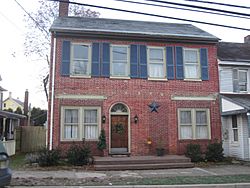
House in Bloomsbury
|
||
|
||
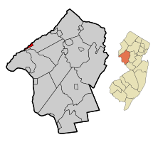
Location of Bloomsbury in Hunterdon County highlighted in red (left). Inset map: Location of Hunterdon County in New Jersey highlighted in orange (right).
|
||
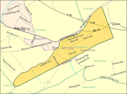
Census Bureau map of Bloomsbury, New Jersey
|
||
| Country | ||
| State | ||
| County | Hunterdon | |
| Incorporated | March 30, 1905 | |
| Government | ||
| • Type | Borough | |
| • Body | Borough Council | |
| Area | ||
| • Total | 0.96 sq mi (2.49 km2) | |
| • Land | 0.93 sq mi (2.42 km2) | |
| • Water | 0.03 sq mi (0.08 km2) 3.23% | |
| Area rank | 509th of 565 in state 24th of 26 in county |
|
| Elevation | 335 ft (102 m) | |
| Population
(2020)
|
||
| • Total | 792 | |
| • Estimate
(2023)
|
796 | |
| • Rank | 542nd of 565 in state 25th of 26 in county |
|
| • Density | 849.4/sq mi (328.0/km2) | |
| • Density rank | 402nd of 565 in state 12th of 26 in county |
|
| Time zone | UTC−05:00 (Eastern (EST)) | |
| • Summer (DST) | UTC−04:00 (Eastern (EDT)) | |
| ZIP Code |
08804
|
|
| Area code(s) | 908 exchange: 479 | |
| FIPS code | 3401906370 | |
| GNIS feature ID | 0885162 | |
| School district | Phillipsburg School District | |
| Website | ||
Bloomsbury is a small town, also called a borough, located in Hunterdon County, New Jersey. In 2020, about 792 people lived there.
Bloomsbury became an official borough on March 30, 1905. It was formed from parts of Bethlehem Township.
Long ago, Bloomsbury was known as "Johnson's Iron Works." This was because Robert Johnson owned an iron business there. The name Bloomsbury might come from the Bloom family, who were important early residents. It could also come from "blooms," which are chunks of wrought iron made from iron ore.
Contents
Where is Bloomsbury?
Bloomsbury is a small place, covering about 0.96 square miles (2.49 square kilometers). Most of this area is land, with a small part being water.
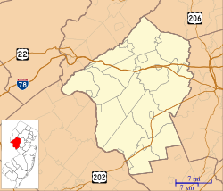
It is located in the northwest part of Hunterdon County. The Musconetcong River runs along its south side. Bloomsbury is one of the smallest towns in Hunterdon County.
It shares borders with several other towns. These include Bethlehem Township in Hunterdon County. It also borders Franklin Township, Greenwich Township, and Pohatcong Township in Warren County.
How Many People Live Here?
| Historical population | |||
|---|---|---|---|
| Census | Pop. | %± | |
| 1880 | 585 | — | |
| 1910 | 600 | — | |
| 1920 | 650 | 8.3% | |
| 1930 | 639 | −1.7% | |
| 1940 | 704 | 10.2% | |
| 1950 | 722 | 2.6% | |
| 1960 | 838 | 16.1% | |
| 1970 | 879 | 4.9% | |
| 1980 | 864 | −1.7% | |
| 1990 | 890 | 3.0% | |
| 2000 | 886 | −0.4% | |
| 2010 | 870 | −1.8% | |
| 2020 | 792 | −9.0% | |
| 2023 (est.) | 796 | −8.5% | |
| Population sources: 1910–1920 1910 1910–1930 1940–2000 2000 2010 2020 |
|||
In 2010, there were 870 people living in Bloomsbury. This number went down to 792 people by 2020.
Schools in Bloomsbury
Students in Bloomsbury attend schools run by the Bloomsbury School District. This district has one school, Bloomsbury Public School. It serves students from pre-kindergarten up to eighth grade.
In the 2022–23 school year, about 96 students were enrolled. There were 15.4 teachers, meaning about 6 students per teacher. This is a very small school district!
Bloomsbury also takes part in a special program. It allows students from other towns to attend its school. The state of New Jersey helps pay for these students.
After eighth grade, students from Bloomsbury go to Phillipsburg High School. This high school is located in Phillipsburg, which is in Warren County. Students from other nearby towns also attend Phillipsburg High School.
If students in Hunterdon County are in eighth grade, they can also apply to a special school. This is the Hunterdon County Vocational School District. It offers classes to help students learn job skills. These programs are free for students to attend.
Getting Around Bloomsbury
Bloomsbury has about 6.77 miles of roads. Most of these roads are taken care of by the town itself.
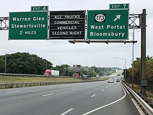
Two major highways, Interstate 78 and U.S. Route 22, pass through the northern part of Bloomsbury. These roads connect Bloomsbury to other places. You can get on or off these highways at Exit 7, which leads to Route 173.
A main county road, County Route 579, also runs through the borough.
For public transportation, there is a bus service called The LINK. This bus serves all of Hunterdon County.
A train line, the Lehigh Line, also goes through the southwest part of Bloomsbury. This line is used for cargo trains.
Famous People from Bloomsbury
Some notable people who have lived in or are connected to Bloomsbury include:
- John T. Bird (1829–1911), who was a representative for New Jersey in the U.S. Congress.
- Carla Katz (born 1959), an attorney who was a leader for a workers' union.
- Jen Ponton (born 1984), an actress, writer, and producer. She is known for her role in the TV show Dietland.
See also
 In Spanish: Bloomsbury (Nueva Jersey) para niños


