Bluffdale, Utah facts for kids
Quick facts for kids
Bluffdale, Utah
|
||
|---|---|---|

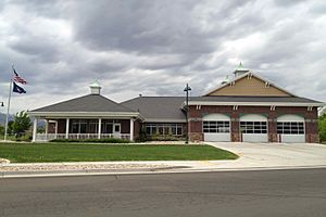
Bluffdale Fire Station in 2013
|
||
|
||

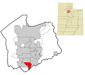
Location in Salt Lake County and the state of Utah.
|
||

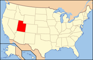
Location of Utah in the United States
|
||
| Country | United States | |
| State | Utah | |
| County | Salt Lake, Utah | |
| Founded | 1886 | |
| Incorporated | October 13, 1978 | |
| Named for | Bluffs and dales along the Jordan River | |
| Area | ||
| • Total | 11.14 sq mi (28.86 km2) | |
| • Land | 11.14 sq mi (28.85 km2) | |
| • Water | 0.00 sq mi (0.01 km2) | |
| Elevation | 4,436 ft (1,352 m) | |
| Population
(2020)
|
||
| • Total | 17,014 | |
| • Density | 1,527.29/sq mi (589.74/km2) | |
| Time zone | UTC-7 (MST) | |
| • Summer (DST) | UTC-6 (MDT) | |
| ZIP code |
84065
|
|
| Area codes | 385, 801 | |
| FIPS code | 49-06810 | |
| GNIS feature ID | 2409871 | |
| Website | bluffdale.com | |
Bluffdale is a city in Utah, located about 20 miles (32 km) south of Salt Lake City. It sits in both Salt Lake and Utah counties. In 2020, about 17,014 people lived there.
Contents
History
Bluffdale got its name from the "bluffs" (cliffs) and "dales" (valleys) found along the Jordan River. The area was first settled between 1848 and 1849. Back then, it was part of a larger area called West Jordan.
A famous person named Orrin Porter Rockwell bought land here in 1858. His property included a hotel, a brewery, and even a station for the Pony Express!
As more people moved in, Bluffdale became part of South Jordan, then Riverton. In 1883, the Bluffdale School Precinct was created for local schools. The city was officially organized in 1886. For a short time, it was even called Mousley.
Bluffdale is important for its water. Seven irrigation canals start near the Jordan Narrows in the area. These canals help bring water to the Salt Lake Valley. One of the oldest, the Utah and Salt Lake Canal, began in 1862. Early buildings included an adobe church (built 1887–1888) and a three-room schoolhouse from 1893. Bluffdale officially became a city in 1978.
Geography
Bluffdale covers about 10.22 square miles (26.47 km2). Its average height is 4,436 feet (1,352 meters) above sea level. Most of Bluffdale is in Salt Lake County, but a small part is in Utah County.
Bluffdale shares its borders with other cities: Herriman to the west, Riverton to the north, Draper to the east, and Lehi to the south.
The city is surrounded by open spaces with amazing views of the Wasatch and Oquirrh Mountain Ranges. The land here was once the bottom of a huge ancient lake called Lake Bonneville. You can still see the old shorelines on the nearby mountains! The Jordan River flows through Bluffdale. It connects Utah Lake to the Great Salt Lake.
Climate
Bluffdale has a semi-arid climate. This means it gets hot summers and cold, snowy winters.
| Weather chart for Bluffdale, Utah | |||||||||||||||||||||||||||||||||||||||||||||||
|---|---|---|---|---|---|---|---|---|---|---|---|---|---|---|---|---|---|---|---|---|---|---|---|---|---|---|---|---|---|---|---|---|---|---|---|---|---|---|---|---|---|---|---|---|---|---|---|
| J | F | M | A | M | J | J | A | S | O | N | D | ||||||||||||||||||||||||||||||||||||
|
1.5
41
25
|
1.2
47
28
|
1.6
57
35
|
1.8
65
41
|
1.8
76
49
|
0.9
88
57
|
1
96
65
|
1
93
64
|
1.1
83
54
|
1.7
68
42
|
1.3
53
33
|
1
42
25
|
||||||||||||||||||||||||||||||||||||
| temperatures in °F precipitation totals in inches |
|||||||||||||||||||||||||||||||||||||||||||||||
|
Metric conversion
|
|||||||||||||||||||||||||||||||||||||||||||||||
Parks
Bluffdale has many great parks for fun and activities!
The biggest park is Wardle Fields Regional Park. It's 40 acres and has a splash pad, a 25-foot tall watchtower, pickleball and basketball courts, bouldering walls, and zip lines.
City Parks
Bluffdale has 13 city parks. Here are some of the most popular:
- Bluffdale City Main Park (22.37 acres) is the city's largest. It has two pavilions, 16 picnic tables, a trail, and sports fields.
- Vintage Park (6.37 acres) is newer. It features pavilions, picnic tables, open grassy areas, two pickleball courts, two tennis courts, a sand volleyball court, and a splash pad.
- Independence Park (5.73 acres) has a splash pad, three pavilions, and lots of play equipment.
- Parry Farms Park (5.63 acres) offers a pavilion, four pickleball courts, a basketball court, and a sledding hill.
- Parry Farms Baseball Fields (7.22 acres) has two fields for little league baseball.
- Phillip Gates Memorial Park (4.54 acres) includes a pavilion, play equipment, and a walking trail.
- Mount Jordan Park (3.69 acres) features open grass, two pavilions, and playground equipment.
Trails
Bluffdale has many beautiful trails for walking, biking, and even horseback riding. A big part of the Jordan River Parkway Trail, which is 40 miles long and crosses three counties, runs through Bluffdale.
Demographics
| Historical population | |||
|---|---|---|---|
| Census | Pop. | %± | |
| 1980 | 1,300 | — | |
| 1990 | 2,152 | 65.5% | |
| 2000 | 4,700 | 118.4% | |
| 2010 | 7,598 | 61.7% | |
| 2020 | 17,014 | 123.9% | |
Bluffdale is part of the larger Salt Lake City metropolitan area.
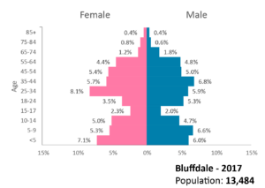
In 2010, there were 7,598 people living in Bluffdale. The population density was about 743.5 people per square mile. Many households (57.8%) had children under 18 living with them. The average household had about 3.86 people.
The population was quite young, with 38.2% of people under 18 years old. The average age was 26 years.
Economy
Camp Williams, a military training base, is located south of Bluffdale. It also hosts the Utah Data Center, which is a very important facility for the United States Intelligence Community.
Education
Schools
Bluffdale is part of the Jordan School District. The city has several public schools, both traditional and charter schools. For example, Bluffdale Elementary School offers a special program where students learn in both English and Portuguese.
Traditional Public Schools
- Bluffdale Elementary School
- Mountain Point Elementary School
- South Hills Middle School (located in Riverton City)
- Hidden Valley Middle School
- Riverton High School (located in Riverton City)
Charter Public Schools
- North Star Academy (Kindergarten to 9th grade)
- Summit Academy (Independence campus)
- Summit Academy (14400 South campus)
- Summit High School
Transportation
Roads
Bluffdale is near several major roads. I-15 runs north and south to the east of the city. Bangerter Highway goes east and west between Bluffdale and Riverton. Mountain View Corridor runs north and south to the west.
Porter Rockwell Boulevard is a big road project that connects I-15 and Mountain View Corridor. It's the only east-to-west connection in this part of the county.
Public transportation
Bluffdale does not have its own public transportation system. The commuter train, FrontRunner, passes through Bluffdale, but it doesn't have a stop there.
Air transportation
The closest major airport is Salt Lake City International Airport, which is about 28 miles (45 km) north of Bluffdale.
See also
 In Spanish: Bluffdale para niños
 | Ernest Everett Just |
 | Mary Jackson |
 | Emmett Chappelle |
 | Marie Maynard Daly |


