Boise Ridge facts for kids
Quick facts for kids Boise Ridge |
|
|---|---|

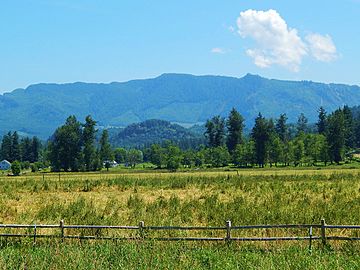
Boise Ridge seen from the west
|
|
| Highest point | |
| Elevation | 3,080 ft (940 m) |
| Prominence | 420 ft (130 m) |
| Geography | |
| Parent range | Cascade Range |
| Topo map | USGS Enumclaw |
| Climbing | |
| Easiest route | Hiking class 2 |
Boise Ridge is a beautiful, tree-covered hill range located in King County, Washington state. It is part of the large Cascade Range of mountains. You can find Boise Ridge on the western edge of these mountains. It sits about four miles east of a town called Enumclaw, Washington. To its west is Grass Mountain, to its south is Enumclaw Mountain, and to its north is Radio Hill.
When rain or snow falls on the east side of Boise Ridge, the water flows into Boise Creek. This creek then joins the White River. On the west side of the ridge, water drains into streams that flow into the Green River.
Climate of Boise Ridge
Boise Ridge is located in a special weather area called the marine west coast climate zone. This means it gets a lot of moisture from the nearby Pacific Ocean. Most of the weather systems, like big clouds and storms, start over the Pacific Ocean. They then travel northeast towards the Cascade Mountains.
When these weather systems reach the tall Cascade Mountains, they are forced to rise up. As the air goes higher, it cools down. This cooling makes the moisture in the air turn into rain or snowfall. This process is called Orographic lift. Because of this, the western side of the Cascade Mountains, including Boise Ridge, gets a lot of rain and snow, especially in winter.
During the winter months, the weather is usually cloudy and wet. However, in the summer, a high-pressure system often forms over the Pacific Ocean. This system brings clear skies and sunny weather to the area.


