Boisvert River (Normandin River tributary) facts for kids
Quick facts for kids Boisvert |
|
|---|---|

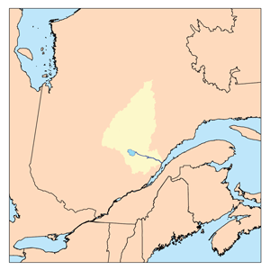
Watershed of Saguenay River
|
|
| Country | Canada |
| Province | Quebec |
| Region | Saguenay-Lac-Saint-Jean |
| Physical characteristics | |
| Main source | Unidentified lake Lac-Ashuapmushuan, Quebec, Le Domaine-du-Roy (RCM), Saguenay-Lac-Saint-Jean, Quebec 467 m (1,532 ft) 49°32′05″N 74°08′18″W / 49.53472°N 74.13833°W |
| River mouth | Charron Lake Lac-Ashuapmushuan, Quebec, Le Domaine-du-Roy (RCM), Saguenay-Lac-Saint-Jean, Quebec 371 m (1,217 ft) 49°12′12″N 73°47′51″W / 49.20333°N 73.79750°W |
| Length | 79.9 km (49.6 mi) |
| Basin features | |
| Tributaries |
|
The Boisvert River is a river in the Saguenay-Lac-Saint-Jean region of Quebec, Canada. It flows into Charron Lake, which is part of the larger Ashuapmushuan Lake system. This river is about 79.9 kilometers (49.6 miles) long.
The Boisvert River flows through an area called Lac-Ashuapmushuan, Quebec, which is an unorganized territory. This means it's a large area without a local government, managed by a larger regional body. The river is important for forestry, which means cutting down trees for wood. It's also a place where people enjoy outdoor activities like fishing and camping.
A main road, Route 167, helps people get to the southern part of the Boisvert River valley. Other forest roads also help access different parts of the river. The river usually freezes over in early November and stays frozen until mid-May. It's safe to travel on the ice from mid-November to mid-April.
Contents
River's Journey
Where the River Starts
The Boisvert River begins in an unnamed lake. This lake is located in the northern part of Quebec, at an elevation of about 467 meters (1,532 feet) above sea level. This starting point is near the Thibaudeau township.
From its source, the river flows generally south. It passes through several small lakes and marshy areas.
Flowing South
As the Boisvert River flows south, it crosses through different townships. These are like land divisions in the area. It goes through Thibaudeau, Bignell, McCorkill, Rinfret, Vimont, Dollier, Charron, and Ducharme.
The river also flows through parts of the Ashuapmushuan Wildlife Reserve. This is a protected area where animals and nature are preserved. The river's path is surrounded by forests, which is why forestry is a big activity here.
Reaching Charron Lake
The Boisvert River eventually flows into Charron Lake. This lake is a key part of the river's journey. From Charron Lake, the water continues to flow through other lakes like Lac la Blanche, Jordan Lake, and Nicabau Lake.
Finally, the water from the Boisvert River joins the Normandin River. The Normandin River then flows into Ashuapmushuan Lake. From there, the water travels down the Ashuapmushuan River to Lac Saint-Jean, and eventually to the Saguenay River, which leads to the Estuary of Saint Lawrence and the Atlantic Ocean.
What's Around the River
The Boisvert River is surrounded by many other rivers and lakes. To the north, you can find Chibougamau Lake and Mistassini Lake. To the east are rivers like the Hogan River and Chief River. To the south, you'll find Rohault Lake and the Normandin River. To the west, there's the Armitage River and Chibougamau Lake. All these waterways are connected in a large network.
River's Name
The name "Boisvert" comes from a French family name. The official name "Boisvert River" was given on December 5, 1968, by the Commission de toponymie du Québec. This commission is responsible for naming places in Quebec.
 | Emma Amos |
 | Edward Mitchell Bannister |
 | Larry D. Alexander |
 | Ernie Barnes |

