Normandin River facts for kids
Quick facts for kids Normandin |
|
|---|---|

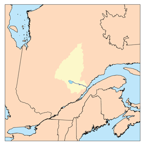
Watershed of Saguenay river
|
|
| Other name(s) | Old name: "Nicabau River" |
| Country | Canada |
| Province | Quebec |
| Region | Nord-du-Québec |
| Physical characteristics | |
| Main source | Normandin Lake (Normandin River) Lac-Ashuapmushuan, Quebec, Le Domaine-du-Roy (RCM), Saguenay-Lac-Saint-Jean, Quebec 403 m (1,322 ft) 48°57′09″N 74°15′41″W / 48.95250°N 74.26139°W |
| River mouth | Ashuapmushuan Lake Lac-Ashuapmushuan, Quebec, Le Domaine-du-Roy (RCM), Saguenay-Lac-Saint-Jean, Quebec 371 m (1,217 ft) 49°12′12″N 73°47′51″W / 49.20333°N 73.79750°W |
| Length | 59.2 km (36.8 mi) |
| Basin features | |
| Tributaries |
|
The Normandin River is a river in Quebec, Canada. It flows into the northern part of Ashuapmushuan Lake. This area is an unorganized territory called Lac-Ashuapmushuan, Quebec. It is part of the Le Domaine-du-Roy region. The river is located in the Saguenay-Lac-Saint-Jean administrative area.
The river flows through several townships, which are like local districts. These include Ventadour, Buade, Poutrincourt, Bouteroue, Ducharme, Aigremont, and Grahamé. The main business in this area is forestry, which means cutting down trees. Tourism and outdoor activities are also very popular.
A road called Route 212 helps people get to the southern part of the Normandin River valley. This road connects Obedjiwan to La Tuque. It goes south of Dubois Lake and Normandin Lake (Normandin River). Another forest road, R0212, crosses the Normandin River.
The Normandin River usually freezes over in early November. It stays frozen until mid-May. It is generally safe to travel on the ice from mid-November to mid-April.
Contents
Where the Normandin River Flows
The Normandin River is surrounded by many other rivers and lakes. These are called its hydrographic slopes.
- To the north, you'll find Nicabau Lake, Coquille River, Boisvert River, Tonnerre River (Normandin River), and Chaudière River.
- To the east are the Marquette River West, Marquette River, Ashuapmushuan River, and Ashuapmushuan Lake.
- To the south, there's Townsend Creek, Berlinguet Lake, Wabano River West, Palluau Lake, Marquette River West, and Marquette River.
- To the west, you'll find the Titipiti River, Ventadour River, Feuquières Lake, Bouteroue Creek, Bouteroue Lake, and Rohault Lake.
The River's Beginning
The Normandin River starts at Normandin Lake (Normandin River). This lake is about 6.7 kilometres (4.2 mi) long. It sits at an elevation of 403 metres (1,322 ft) above sea level. The lake is in the Ventadour Township.
The start of Normandin Lake is inside the Ashuapmushuan Wildlife Reserve. It's about 5.1 kilometres (3.2 mi) west of the border of the Eeyou Istchee James Bay (municipality) and Le Domaine-du-Roy regions. Normandin Lake gets its water mainly from Townsend Creek. It also gets water from other lakes to the north, like Anctil, Vinet, Dorval, and Képi.
The River's Journey
From Normandin Lake, the river flows for about 98.4 kilometres (61.1 mi). It passes through several lakes and areas.
Upper Part of the River
The first part of the river is about 33.4 kilometres (20.8 mi) long.
- It flows northeast for a short distance to Little Buade Lake.
- Then, it crosses all of Little Buade Lake, which is at 400 metres (1,300 ft) elevation.
- After that, it flows north through an area called "Foul Fall" to the south bay of Buade Lake (Normandin River).
- Finally, it crosses all of Buade Lake (Normandin River), which is at 392 metres (1,286 ft) elevation.
Middle Part of the River
The middle section of the river is about 26.3 kilometres (16.3 mi) long.
- It flows north, making a turn to the east, until it reaches the south bay of Poutrincourt Lake.
- It then flows north through the middle of Poutrincourt Lake, which is also at 392 metres (1,286 ft) elevation.
- Next, it flows north, making a turn to the east, until it reaches the south bay of Nicabau Lake.
- It then crosses the southern part of Nicabau Lake, which is at 386 metres (1,266 ft) elevation.
Lower Part of the River
The last part of the river is about 38.7 kilometres (24.0 mi) long.
- It flows east to the west shore of Ducharme Lake.
- Then, it crosses all of Ducharme Lake, which is at 382 metres (1,253 ft) elevation.
- It continues east, making a loop to the south, until it reaches where the Chaudière River joins it.
- It then flows southeast, making some turns, until it reaches a road bridge.
- Finally, it continues southeast until it reaches its mouth.
Where the River Ends
The Normandin River flows into a bay on the northwestern shore of Ashuapmushuan Lake. From there, the water flows into the Ashuapmushuan River. The Ashuapmushuan River then flows to Saint-Félicien, Quebec and into the western shore of Lac Saint-Jean.
The place where the Normandin River meets Ashuapmushuan Lake is:
- About 122.6 kilometres (76.2 mi) northwest of where the Ashuapmushuan River meets Lac Saint-Jean.
- About 162 kilometres (101 mi) east of the mouth of Lac Saint-Jean.
- About 321.6 kilometres (199.8 mi) east of the mouth of the Saguenay River, where it meets the Estuary of Saint Lawrence.
River's Name
The name "Normandin" comes from a French family name.
The official name "Normandin River" was given on December 5, 1968. This was done by the Commission de toponymie du Québec, which is a group that names places in Quebec.
 | Precious Adams |
 | Lauren Anderson |
 | Janet Collins |

