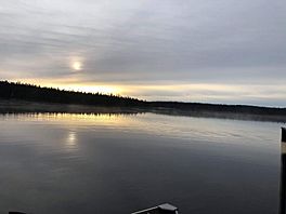
Bouteroue Lake facts for kids
Quick facts for kids Bouteroue Lake |
|
|---|---|

Bouteroue Lake in July 2020
|
|
| Location | Le Domaine-du-Roy (RCM) |
| Coordinates | 49°20′23″N 74°14′51″W / 49.33972°N 74.24750°W |
| Type | Natural |
| Primary inflows |
|
| Primary outflows | Bouteroue Creek |
| Basin countries | Canada |
| Max. length | 16.9 kilometres (10.5 mi) |
| Max. width | 2.2 kilometres (1.4 mi) |
| Surface area | 83.87 kilometres (52.11 mi) |
| Surface elevation | 402 metres (1,319 ft) |
Bouteroue Lake is a large freshwater lake in Quebec, Canada. It is located in a wild area called Lac-Ashuapmushuan, Quebec, which is part of the Le Domaine-du-Roy region. This lake is in the Saguenay–Lac-Saint-Jean area of Quebec.
The main activities around the lake are forestry (cutting down trees for wood) and tourism (people visiting for fun).
A forest road, route 167, runs near the lake. This road connects the towns of Chibougamau and Saint-Félicien, Quebec. A train track also follows this road. The northern part of Bouteroue Lake can be reached by another forest road that goes to the Nemenjiche River.
Bouteroue Lake usually freezes over in early November. The ice stays until mid-May. It's generally safe to be on the ice from mid-November to mid-April.
About Bouteroue Lake
Bouteroue Lake is a long lake, about 16.9 kilometres (10.5 mi) (10.5 miles) long. It is up to 2.2 kilometres (1.4 mi) (1.4 miles) wide. The lake sits at an elevation of 402 metres (1,319 ft) (1,319 feet) above sea level.
The lake has a very interesting and complex shape. It has many bays and peninsulas (pieces of land sticking into the water). The lake is divided into five main parts:
- The northern part has about twenty islands. Water from Rohault Lake flows into this part.
- The eastern part forms a U-shaped bay.
- The western part has a long peninsula. It also receives water from several other lakes like Madère, Djebel, Ribemont, and Mayac.
- The central part is the longest, running from north to south. Lakes Pertain, Ivors, and Rhea flow into this section.
- The southern part looks like a double hook. One hook is called the "Bay of Wisdom." This part receives water from Finbar Lake.
Where the Water Goes
The water from Bouteroue Lake flows out through Bouteroue Creek. This creek then empties into a bay in Nicabau Lake.
Nicabau Lake is fed by the Boisvert River and the Normandin River. The Normandin River then flows southeast into Ashuapmushuan Lake. Ashuapmushuan Lake is the starting point for the Ashuapmushuan River. Finally, the Ashuapmushuan River flows into Lac Saint-Jean, which then connects to the Saguenay River.
Nearby Rivers and Lakes
Many other rivers and lakes are close to Bouteroue Lake.
- To the north: Nicabau Lake, Coquille River, La Dauversière Lake.
- To the east: Chaudière River, Normandin River.
- To the south: Buade Lake (Normandin River), Poutrincourt Lake, Marquette River West.
- To the west: Rohault Lake, Nemenjiche Lake, Opawica River.
Name of the Lake
Long ago, Bouteroue Lake was known by a different name: "Owen Lake."
The name "Lac Bouteroue" was officially given on December 5, 1968. This was when the Commission de toponymie du Québec (Quebec's place name commission) was first created.
 | James B. Knighten |
 | Azellia White |
 | Willa Brown |


