Boyce, Virginia facts for kids
Quick facts for kids
Boyce, Virginia
|
|
|---|---|
|
Town
|
|

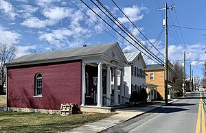
Boyce Historic District, including the town hall (foreground)
|
|

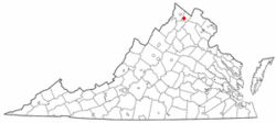
Location of Boyce in Virginia
|
|
| Country | |
| State | |
| County | |
| Area | |
| • Total | 0.37 sq mi (0.95 km2) |
| • Land | 0.37 sq mi (0.95 km2) |
| • Water | 0.00 sq mi (0.00 km2) |
| Elevation | 597 ft (182 m) |
| Population
(2010)
|
|
| • Total | 589 |
| • Estimate
(2019)
|
627 |
| • Density | 1,708.45/sq mi (659.26/km2) |
| Time zone | UTC−5 (Eastern (EST)) |
| • Summer (DST) | UTC−4 (EDT) |
| ZIP code |
22620
|
| Area code(s) | 540 |
| FIPS code | 51-08984 |
| GNIS feature ID | 1492615 |
Boyce is a small town in Clarke County, Virginia, in the United States. It's a quiet place with a friendly community. In 2020, about 749 people lived there. This was an increase from 589 people in 2010.
Contents
Geography of Boyce
Boyce is located in the western part of Clarke County. You can find it along U.S. Route 340. It's about 6 miles (9.7 km) southwest of Berryville, which is the county seat. It's also about 16 miles (26 km) northeast of Front Royal.
The town covers an area of about 0.37 square miles (0.95 km2). All of this area is land. Boyce sits on a ridge. Water from the east side of the ridge flows into Page Brook. Water from the west side flows into Roseville Run. The town has a deep well, reaching about 165 feet (50 m) down.
Who Lives in Boyce?
| Historical population | |||
|---|---|---|---|
| Census | Pop. | %± | |
| 1920 | 301 | — | |
| 1930 | 325 | 8.0% | |
| 1940 | 342 | 5.2% | |
| 1950 | 372 | 8.8% | |
| 1960 | 384 | 3.2% | |
| 1970 | 378 | −1.6% | |
| 1980 | 401 | 6.1% | |
| 1990 | 520 | 29.7% | |
| 2000 | 426 | −18.1% | |
| 2010 | 589 | 38.3% | |
| 2020 | 749 | 27.2% | |
| U.S. Decennial Census | |||
In 2000, there were 426 people living in Boyce. These people lived in 159 households. About 114 of these were families. The town had about 1,180 people per square mile (457/km2).
- Most people (86.38%) were White.
- About 11.74% were African American.
- A small number were Native American or Asian.
About 27% of households had children under 18. Most households (57.2%) were married couples. The average household had about 2.68 people. The average family had about 3.19 people.
The median age in Boyce was 37 years old. About 25.8% of the population was under 18. About 13.1% were 65 or older.
History of Boyce
How Boyce Became a Town
The town of Boyce officially became a town on November 28, 1910. At that time, it had 312 people. The first election for a mayor and four council members happened on December 20, 1910. W. M. Gaunt became the first Mayor.
The Railroad's Role
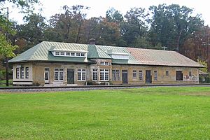
The Norfolk & Western Railway (now Norfolk Southern) runs right through the middle of Boyce. When the railroad was built in 1881, this area was a dense forest. The railroad company built a large station in Boyce in 1912.
The Shenandoah Valley Railroad was built in Clarke County in 1879. It connected Hagerstown, Maryland, to Roanoke, Virginia. The railroad opened its route to Berryville on October 1, 1879.
Boyce started to grow in 1881 when the Shenandoah Valley Railroad arrived. The town was built where the railroad crossed the Millwood Turnpike. Boyce was named after Colonel Upton L. Boyce. He lived nearby and helped convince the railroad to come through Clarke County.
The first train station in Boyce was small. It was located near the Millwood Turnpike. In the early 1910s, the railroad planned to replace it with another small wooden building. However, the people of Boyce and nearby Millwood wanted a bigger, nicer station. They even raised money to help pay for a larger building.
A newspaper article from 1912, The Clarke Courier, mentioned the "New Depot for Boyce." It said that the people of Boyce wanted a better station. They were willing to contribute to help their town grow.
The new train station was finished in late 1913. Another article from The Clarke Courier in 1913 described it as "magnificent." It had concrete platforms, a long train shed, and electric lights. It also had modern conveniences for travelers.
In 1914, the station was described as having 400 feet (120 m) of train shed and 540 feet (160 m) of concrete platform. It also had 3 acres (1.2 ha) of grounds and tracks. This was a very large station for a small town like Boyce.
The Boyce train station was much bigger than the one in Berryville, the county seat. This was partly because many wealthy people lived around Boyce and Millwood. They were interested in fox hunting, horse breeding, and cattle raising. They wanted a larger station to transport their thoroughbred horses and cattle.
The Boyce Railroad Station is special because the local citizens helped pay for its construction. They wanted a more impressive building than what the railroad first planned.
Today, the Boyce train station is one of the few large, elegant stations left in this part of Virginia. It reminds us of how important the railroad was. It also shows the hard work of the local people who helped build it.
Town Facilities and Churches
Boyce has water pipes running along its main street. The fire department is located where Main Street meets U.S. Route 340. The town also owns an electric plant. This plant has a powerful dynamo to provide light and power.
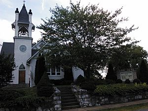
In 1914, Boyce had an Episcopal church and a Methodist church. It also had a Baptist parsonage. The Episcopal church was electrically lighted. The town also had a brick high school with about 200 students. There was a bank, a hotel, and several stores.
Today, the large stone Episcopal Church is being renovated. Its members now go to nearby churches. However, the Baptist and Methodist churches are still active.
Historic Places to See
Several places near Boyce are listed on the National Register of Historic Places. This means they are important historical sites. Some of these include:
- Boyce Historic District
- Blandy Experimental Farm Historic District
- Greenway Historic District
- Annefield
- Huntingdon
- Millwood Colored School
- Saratoga—the home of Gen. Daniel Morgan
- Scaleby
Other Interesting Spots
- Orland E. White Research Arboretum
Getting Around Boyce
The main road in Boyce is U.S. Route 340. This road runs northeast to southwest. It generally runs parallel to Interstate 81 and U.S. Route 11, which are to the west. US 340 connects to other important roads like U.S. Route 17 and U.S. Route 50.
Schools in Boyce
Boyce has two schools:
- Boyce Elementary School (a public school)
- Powhatan School (a private school for grades PK-8)
See also
 In Spanish: Boyce (Virginia) para niños
 | James Van Der Zee |
 | Alma Thomas |
 | Ellis Wilson |
 | Margaret Taylor-Burroughs |


