Bradmoor Island facts for kids

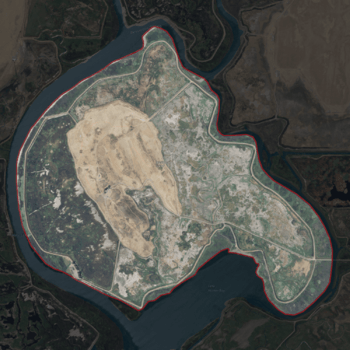
USGS aerial imagery of Bradmoor Island
|
|
| Geography | |
|---|---|
| Location | Northern California |
| Coordinates | 38°11′26″N 121°55′05″W / 38.19056°N 121.91806°W |
| Adjacent bodies of water | Sacramento–San Joaquin River Delta |
| Highest elevation | 52 ft (15.8 m) |
| Administration | |
|
United States
|
|
| State | |
| County | Solano |
Bradmoor Island is an island located in Suisun Bay, a large body of water in Northern California. It's part of Solano County. This island is a natural landform and is not managed by a special water district called a reclamation district.
About Bradmoor Island
Bradmoor Island is a small piece of land completely surrounded by water. It is a natural island, meaning it formed over time without human help. Unlike some other islands in the area, it does not have a special district to manage its water levels or protect it from floods.
Where is Bradmoor Island?
Bradmoor Island is found in Suisun Bay. This bay is an important part of the Sacramento–San Joaquin River Delta. The Delta is a huge area where the Sacramento River and San Joaquin River meet. From there, their waters flow towards the San Francisco Bay and out to the Pacific Ocean. Bradmoor Island is located in the western part of this large water system. Its exact spot is at 38°11′26″N 121°55′05″W / 38.19056°N 121.91806°W.
How High is Bradmoor Island?
In 1981, the United States Geological Survey (USGS) measured the elevation of Bradmoor Island. They found it was about 52 ft (16 m) above sea level. This means the highest point on the island is not very far above the water around it.


