
Brahmanbaria District facts for kids
Quick facts for kids
Brahmanbaria
ব্রাহ্মণবাড়িয়া
|
|
|---|---|

Location of Brahmanbaria in Bangladesh
|
|
| Country | |
| Division | Chittagong Division |
| Area | |
| • Total | 1,927.11 km2 (744.06 sq mi) |
| Bhadughar Meela = Bhadughar Boishahi Meela (14th Boishah) | |
| Population
(1991)
|
|
| • Total | 2,365,880 |
| • Density | 1,227.683/km2 (3,179.684/sq mi) |
| Literacy rate | |
| • Total | 26.6% |
| Time zone | UTC+6 (BST) |
| • Summer (DST) | UTC+7 (BDST) |
| Postal code |
3400
|
| Website | http://www.dcbrahmanbaria.gov.bd/ |
Brahmanbaria (pronounced Bramhonbaŗia in Bengali) is a district located in the east-central part of Bangladesh. It belongs to the Chittagong Division. This area became its own district in 1984, after being part of the larger Comilla District. Before 1830, a part of the district called Sarail Pargana was part of Mymensingh district.
The district has 4 municipalities, which are like small cities. It also has 7 upazilas (sub-districts), 98 union parishads (local councils), and many villages.
Geography of Brahmanbaria
Brahmanbaria District is found in the east-central area of Bangladesh. It covers a total land area of about 1927 square kilometers.
Borders and Neighbors
Brahmanbaria shares its borders with several other places:
- To the north: Kishoreganj District and Habiganj District
- To the south: Comilla District
- To the east: Habiganj District and the Tripura State in India
- To the west: The Meghna River, Kishoreganj District, Narsingdi District, and Narayanganj District
Land Features
The land in Brahmanbaria is mostly low-lying. This means it is quite flat. There are also some small hills scattered around the district.
Images for kids
-

Isa Khan, a famous leader from the 1500s, had his capital in Sarail.
-
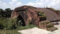
The Hatirpul is a very old bridge built in Bariura. It was used as a path for elephants.
-
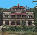
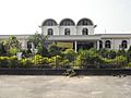
The Gokarna Nawab Bari Complex was built by Nawab Sir Syed Shamsul Huda in Nasirnagar.
-
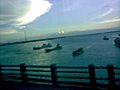
Port of Ashuganj on the Meghna River. This port is expected to become the largest in Bangladesh by 2030.
-
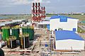
A power plant that helps provide electricity to the country.
-
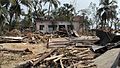
The effects of a tornado that hit Brahmanbaria in 2013.
-
Akhaura is the biggest railway junction in Bangladesh, where many train lines meet.


.jpg)

See also
 In Spanish: Brahmanbaria (zila) para niños
