
Brean facts for kids
Quick facts for kids Brean |
|
|---|---|
 Brean Sands and village from Brean Down |
|

Brean
|
|
| Population | 635 (2011) |
| OS grid reference | ST296560 |
| Unitary authority |
|
| Ceremonial county | |
| Region | |
| Country | England |
| Sovereign state | United Kingdom |
| Post town | BURNHAM-ON-SEA |
| Postcode district | TA8 |
| Dialling code | 01278 |
| Police | Avon and Somerset |
| Fire | Devon and Somerset |
| Ambulance | South Western |
| EU Parliament | South West England |
| UK Parliament |
|
Brean is a small village in Somerset, England. It is located between the towns of Weston-super-Mare and Burnham-on-Sea. The name "Brean" comes from an old Welsh word, "Bryn," which means "hill." About 635 people lived here in 2011.
Right next to the village is Brean Down. This is a tall piece of land that sticks out into the Bristol Channel. It is about 320 feet (98 meters) high and stretches 1.5 miles (2.4 kilometers) into the sea. At the end of Brean Down, you can find Brean Down Fort. This fort marks the end of Weston Bay.
The village itself sits on a narrow strip of land. On one side is the sea, and on the other is the River Axe. Brean is a popular place for tourists. It has Brean Leisure Park, a tropical bird garden, and many caravan parks. The sandy beach is also famous for land sailing, a sport that has been enjoyed here since 1970. Sometimes, Brean is even grouped with the nearby village of Berrow.
A Look Back in Time at Brean
Brean has a long history. It was once part of an old area called the Hundred of Bempstone.
A very big flood hit Brean in 1607. This was part of the Bristol Channel floods. Seven out of nine houses in the village were destroyed. Sadly, 26 people also lost their lives in this flood.
In 1989, a special building called Windmill House was built in Brean. It was one end of a huge underwater cable called PTAT-1. This cable helped send phone calls and data across the Atlantic Ocean to the United States. It stopped working in 2004.
How Brean is Governed
The local people in Brean have a say in how their village is run. This is done through the parish council. The council helps with many local issues.
For example, they decide on a small local tax to cover their costs. They also check plans for new buildings in the area. The council works with the police and local groups to keep the village safe. They also help with things like roads, footpaths, and keeping the streets clean. Looking after local trees and important old buildings is also part of their job.
Since April 1, 2023, Brean has been part of the Somerset Council. This is a larger local government group that looks after many towns and villages in Somerset.
Brean is also part of a larger area called a county constituency. This area chooses one person to represent them in the House of Commons in the Parliament of the United Kingdom. This person is called a Member of Parliament (MP).
Places of Worship
The main church in Brean is called the Church of St Bridget. It was first built in the 1200s. Most of the church you see today is from the 1400s. It was also rebuilt quite a bit around 1882.
This church is considered a very important historical building. It is named after St Bridget of Ireland. She was an important religious leader who died in 525 AD. Naming the church after her suggests that early Christian settlers from Celtic areas might have lived here long ago.
Gallery
-
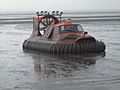
A rescue hovercraft on the sand at Brean.
-
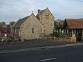
St Bridget's Church in Brean.
-
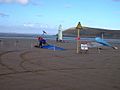
Land yachts racing on Brean beach.
-
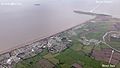
An aerial view showing Brean from above.


