Brent, Alabama facts for kids
Quick facts for kids
Brent
|
|||||
|---|---|---|---|---|---|
|
|||||
| Motto(s):
Proven by Tempest
|
|||||

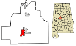
Location of Brent in Bibb County, Alabama.
|
|||||
| Country | United States | ||||
| State | Alabama | ||||
| County | Bibb | ||||
| Area | |||||
| • Total | 8.83 sq mi (22.87 km2) | ||||
| • Land | 8.80 sq mi (22.79 km2) | ||||
| • Water | 0.03 sq mi (0.08 km2) | ||||
| Elevation | 240 ft (70 m) | ||||
| Population
(2020)
|
|||||
| • Total | 2,972 | ||||
| • Density | 337.69/sq mi (130.38/km2) | ||||
| Time zone | UTC-6 (Central (CST)) | ||||
| • Summer (DST) | UTC-5 (CDT) | ||||
| ZIP code |
35034
|
||||
| Area code(s) | 205, 659 | ||||
| FIPS code | 01-09136 | ||||
| GNIS feature ID | 0159248 | ||||
Brent is a city located in Bibb County, Alabama, in the United States. In 2020, about 2,972 people lived there.
Contents
History of Brent
Brent was started in 1898. It was built along a railroad line in the southern part of Bibb County. The city was named after Brent H. Armstrong, who was a surveyor. In 1913, Brent officially became a town.
On May 27, 1973, a very strong tornado hit Brent. This tornado was an F4, which means it was extremely powerful. It caused a lot of damage and sadly, five people died. Many others were hurt. This tornado traveled for 139 miles, which is the longest path for a tornado in Alabama's history. It started near Demopolis and ended at Cheaha Mountain. The nearby city of Centreville also had a lot of damage.
Brent was rebuilt after this disaster. However, on March 25, 2021, another strong tornado, an EF3, hit the city. This tornado also damaged Centreville and completely destroyed the Bibb County Airport.
Geography of Brent
Brent is located in the middle of Bibb County. It sits in the valley of the Cahaba River. The city is right next to Centreville, which is the county seat. The Cahaba River separates the two cities.
U.S. Route 82 goes through the northern part of Brent. This road can take you about 32 miles (51 km) northwest to Tuscaloosa. It can also take you about 73 miles (117 km) southeast to Montgomery, which is Alabama's capital city.
The U.S. Census Bureau says that Brent covers a total area of about 8.8 square miles (22.8 km2). Most of this area, about 8.8 square miles (22.7 km2), is land. Only a small part, about 0.039 square miles (0.1 km2), is water.
Brent's Climate
The weather in Brent has hot and humid summers. The winters are usually mild to cool. Brent has a humid subtropical climate. This means it gets a lot of rain throughout the year, and the temperatures are generally warm.
| Climate data for Brent, 1991–2020 simulated normals (282 ft elevation) | |||||||||||||
|---|---|---|---|---|---|---|---|---|---|---|---|---|---|
| Month | Jan | Feb | Mar | Apr | May | Jun | Jul | Aug | Sep | Oct | Nov | Dec | Year |
| Mean daily maximum °F (°C) | 55.9 (13.3) |
60.6 (15.9) |
68.9 (20.5) |
76.5 (24.7) |
83.7 (28.7) |
89.8 (32.1) |
92.3 (33.5) |
91.9 (33.3) |
87.6 (30.9) |
77.7 (25.4) |
66.6 (19.2) |
58.3 (14.6) |
75.8 (24.3) |
| Daily mean °F (°C) | 44.8 (7.1) |
48.6 (9.2) |
55.8 (13.2) |
63.1 (17.3) |
71.4 (21.9) |
78.6 (25.9) |
81.3 (27.4) |
80.8 (27.1) |
75.7 (24.3) |
64.9 (18.3) |
53.6 (12.0) |
47.3 (8.5) |
63.8 (17.7) |
| Mean daily minimum °F (°C) | 33.6 (0.9) |
36.5 (2.5) |
42.6 (5.9) |
49.6 (9.8) |
59.2 (15.1) |
67.3 (19.6) |
70.5 (21.4) |
69.8 (21.0) |
63.9 (17.7) |
52.0 (11.1) |
40.6 (4.8) |
36.3 (2.4) |
51.8 (11.0) |
| Average precipitation inches (mm) | 5.45 (138.42) |
5.74 (145.75) |
5.43 (137.81) |
4.99 (126.69) |
3.92 (99.57) |
4.58 (116.23) |
4.66 (118.42) |
4.23 (107.36) |
4.11 (104.39) |
3.17 (80.45) |
4.60 (116.81) |
5.34 (135.52) |
56.22 (1,427.42) |
| Average dew point °F (°C) | 35.8 (2.1) |
38.5 (3.6) |
43.7 (6.5) |
51.4 (10.8) |
60.8 (16.0) |
68.2 (20.1) |
71.2 (21.8) |
70.5 (21.4) |
65.3 (18.5) |
54.9 (12.7) |
44.1 (6.7) |
39.2 (4.0) |
53.6 (12.0) |
| Source: Prism Climate Group | |||||||||||||
Brent's Population and People
| Historical population | |||
|---|---|---|---|
| Census | Pop. | %± | |
| 1920 | 386 | — | |
| 1930 | 586 | 51.8% | |
| 1940 | 829 | 41.5% | |
| 1950 | 1,100 | 32.7% | |
| 1960 | 1,879 | 70.8% | |
| 1970 | 2,093 | 11.4% | |
| 1980 | 2,862 | 36.7% | |
| 1990 | 2,776 | −3.0% | |
| 2000 | 4,024 | 45.0% | |
| 2010 | 4,947 | 22.9% | |
| 2020 | 2,972 | −39.9% | |
| U.S. Decennial Census 2013 Estimate |
|||
2020 Census Information
In 2020, the city of Brent had 2,972 people living there. There were 1,055 households and 762 families.
| Race | Number of People | Percentage |
|---|---|---|
| White (not Hispanic) | 1,507 | 50.71% |
| Black or African American (not Hispanic) | 1,286 | 43.27% |
| Native American | 2 | 0.07% |
| Asian | 4 | 0.13% |
| Other/Mixed | 77 | 2.59% |
| Hispanic or Latino | 96 | 3.23% |
2010 Census Information
In 2010, Brent had a population of 4,947 people. There were 1,178 households. About 30.5% of these households had children under 18 living with them.
The population was made up of different groups:
- 53.5% were Black or African American.
- 45.1% were White.
- A small number were Native American or Asian.
- About 2.1% of the people were Hispanic or Latino.
Transportation in Brent
You can find intercity bus service in Brent. Greyhound Lines provides these bus services.
Famous People from Brent
- Charles Cleveland was a professional basketball player. He played for the Philadelphia 76ers.
- George Paul Kornegay was an outsider artist and a Methodist minister. His special art environment was located on a hill near Brent.
See also
 In Spanish: Brent (Alabama) para niños
 | Janet Taylor Pickett |
 | Synthia Saint James |
 | Howardena Pindell |
 | Faith Ringgold |


