Brevard, North Carolina facts for kids
Quick facts for kids
Brevard, North Carolina
|
||
|---|---|---|

Transylvania County Courthouse in Brevard
|
||
|
||

Location of Brevard, North Carolina
|
||
| Country | United States | |
| State | North Carolina | |
| County | Transylvania | |
| Founded | 1861 | |
| Incorporated | 1889 | |
| Named for | Ephraim Brevard | |
| Area | ||
| • Total | 5.36 sq mi (13.88 km2) | |
| • Land | 5.36 sq mi (13.87 km2) | |
| • Water | 0.00 sq mi (0.01 km2) | |
| Elevation | 2,149 ft (655 m) | |
| Population
(2020)
|
||
| • Total | 7,744 | |
| • Density | 1,445.59/sq mi (558.15/km2) | |
| Time zone | UTC−5 (Eastern (EST)) | |
| • Summer (DST) | UTC−4 (EDT) | |
| ZIP code |
28712
|
|
| Area code(s) | 828 | |
| FIPS code | 37-07720 | |
| GNIS feature ID | 2403920 | |
Brevard (/brəˈvɑːrd/ BRƏ-vard) is a city in North Carolina, United States. It is the main town, or county seat, of Transylvania County, North Carolina. In 2020, about 7,744 people lived there.
Brevard is located right at the edge of Pisgah National Forest. It's a popular spot for tourists and people who want to retire. Many people love the area for its mild weather, beautiful nature, and fun cultural events.
The city is also famous for its unique white squirrels! No one is quite sure how they got there. Some stories say they came from an overturned carnival truck. Others believe an escaped pet white squirrel bred with the local gray squirrels.
Brevard is part of a larger area that includes nearby Asheville and Hendersonville.
Contents
History of Brevard
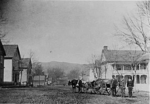
The story of Brevard begins with the creation of Transylvania County. On February 15, 1861, the North Carolina government decided to create this new county. It was formed from parts of Jackson and Henderson counties.
A new county needed a main town, or county seat. This town had to be easy for most people in the county to reach. The town was named Brevard to honor Colonel Ephraim Brevard, M.D. He was a respected soldier who fought in the American Revolutionary War.
Geography and Climate
Brevard covers an area of about 5.12 square miles (13.26 square kilometers). Most of this area is land, with only a tiny bit of water.
Weather in Brevard
Brevard is in a special type of temperate rainforest. This means it gets a lot of rain all year! Its weather is a mix of a humid subtropical and oceanic climate.
The city gets so much rain because of its location in the Blue Ridge Mountains. The nearby Great Balsam Mountains also play a role. When moist air from the ocean hits these mountains, it's forced to rise. As it rises, it cools and drops its moisture as rain. This process is called orographic lift.
Brevard is one of the wettest towns in the United States, outside of the Pacific Northwest. It can also get small amounts of snow in the winter. While there isn't a truly dry season, fall usually has the least amount of rain.
| Climate data for Brevard, North Carolina (1991–2020 normals, extremes 1902–present) | |||||||||||||
|---|---|---|---|---|---|---|---|---|---|---|---|---|---|
| Month | Jan | Feb | Mar | Apr | May | Jun | Jul | Aug | Sep | Oct | Nov | Dec | Year |
| Record high °F (°C) | 85 (29) |
79 (26) |
89 (32) |
90 (32) |
96 (36) |
98 (37) |
99 (37) |
99 (37) |
97 (36) |
92 (33) |
82 (28) |
79 (26) |
99 (37) |
| Mean daily maximum °F (°C) | 48.8 (9.3) |
52.6 (11.4) |
59.7 (15.4) |
69.0 (20.6) |
75.1 (23.9) |
80.6 (27.0) |
82.8 (28.2) |
81.7 (27.6) |
76.7 (24.8) |
69.2 (20.7) |
59.1 (15.1) |
51.0 (10.6) |
67.2 (19.6) |
| Daily mean °F (°C) | 37.0 (2.8) |
39.9 (4.4) |
46.5 (8.1) |
55.0 (12.8) |
62.5 (16.9) |
69.5 (20.8) |
72.5 (22.5) |
71.7 (22.1) |
66.0 (18.9) |
56.3 (13.5) |
45.7 (7.6) |
39.3 (4.1) |
55.2 (12.9) |
| Mean daily minimum °F (°C) | 25.2 (−3.8) |
27.3 (−2.6) |
33.2 (0.7) |
40.9 (4.9) |
50.0 (10.0) |
58.3 (14.6) |
62.2 (16.8) |
61.7 (16.5) |
55.4 (13.0) |
43.4 (6.3) |
32.2 (0.1) |
27.7 (−2.4) |
43.1 (6.2) |
| Record low °F (°C) | −15 (−26) |
−20 (−29) |
−2 (−19) |
14 (−10) |
25 (−4) |
31 (−1) |
41 (5) |
33 (1) |
29 (−2) |
15 (−9) |
2 (−17) |
−12 (−24) |
−20 (−29) |
| Average precipitation inches (mm) | 6.98 (177) |
5.38 (137) |
5.88 (149) |
5.83 (148) |
5.63 (143) |
6.83 (173) |
6.30 (160) |
7.56 (192) |
6.07 (154) |
6.15 (156) |
5.87 (149) |
7.09 (180) |
75.57 (1,919) |
| Average snowfall inches (cm) | 1.7 (4.3) |
1.4 (3.6) |
0.8 (2.0) |
0.0 (0.0) |
0.0 (0.0) |
0.0 (0.0) |
0.0 (0.0) |
0.0 (0.0) |
0.0 (0.0) |
0.0 (0.0) |
0.2 (0.51) |
3.0 (7.6) |
7.1 (18) |
| Average precipitation days (≥ 0.01 in) | 9.8 | 9.5 | 12.1 | 10.6 | 11.6 | 14.2 | 15.3 | 14.4 | 10.0 | 8.4 | 8.1 | 10.6 | 134.6 |
| Average snowy days (≥ 0.1 in) | 0.6 | 0.6 | 0.2 | 0.0 | 0.0 | 0.0 | 0.0 | 0.0 | 0.0 | 0.0 | 0.0 | 0.6 | 2.0 |
| Source: NOAA | |||||||||||||
People of Brevard
| Historical population | |||
|---|---|---|---|
| Census | Pop. | %± | |
| 1880 | 223 | — | |
| 1890 | 327 | 46.6% | |
| 1900 | 584 | 78.6% | |
| 1910 | 919 | 57.4% | |
| 1920 | 1,658 | 80.4% | |
| 1930 | 2,339 | 41.1% | |
| 1940 | 3,061 | 30.9% | |
| 1950 | 3,908 | 27.7% | |
| 1960 | 4,857 | 24.3% | |
| 1970 | 5,243 | 7.9% | |
| 1980 | 5,323 | 1.5% | |
| 1990 | 5,388 | 1.2% | |
| 2000 | 6,789 | 26.0% | |
| 2010 | 7,609 | 12.1% | |
| 2020 | 7,744 | 1.8% | |
| U.S. Decennial Census | |||
2020 Census Information
In 2020, the census showed that 7,744 people lived in Brevard. There were 3,530 households and 2,005 families.
| Race | Number | Percentage |
|---|---|---|
| White (non-Hispanic) | 6,140 | 79.29% |
| Black or African American (non-Hispanic) | 677 | 8.74% |
| Native American | 25 | 0.32% |
| Asian | 75 | 0.97% |
| Pacific Islander | 15 | 0.19% |
| Other/Mixed | 386 | 4.98% |
| Hispanic or Latino | 426 | 5.5% |
2010 Census Information
According to the 2010 census, Brevard had 7,609 people. The city had about 1,486 people per square mile.
Most of the people in Brevard were White (83.3%). About 11.0% were African American. Other groups included Native American (0.3%), Asian (1.0%), and people of two or more races (2.7%). About 3.7% of the population was Hispanic or Latino.
The average age of people in Brevard was 45 years old. About 18.3% of the population was under 18. About 28.2% were 65 years or older.
Fun Things to Do in Brevard
Brevard has many exciting events and cultural activities throughout the year.
White Squirrel Festival
This festival celebrates Brevard's famous white squirrels! It happens on the Friday, Saturday, and Sunday before Memorial Day. You can enjoy live music, see arts and crafts, and try delicious food. The festival even features a mascot named Pisgah Pete, who is a white squirrel!
Independence Day Celebration
July 4th is a huge event in Brevard. The city has a big fireworks show and a car judging contest. Downtown streets are closed for a festival with games, crafts, concerts, and food.
Halloweenfest
Halloweenfest takes place on the last Saturday of October in downtown Brevard. Since Brevard is in Transylvania County, people really get into the Halloween spirit with amazing costumes! The event includes live music, street performers, arts and crafts, and a "Flight of the Vampires 5K Run." There's also a pet costume contest, a haunted house, and a ghost tour.
Twilight Tour
This event is held around Christmas. It starts early in the morning with the Reindeer Run 5K. In the afternoon, street vendors set up downtown after traffic is stopped. The Christmas Parade goes down South Broad Street, ending at Brevard College. After the parade, the Twilight Tour begins. You can enjoy horse-drawn carriages, glowing luminaries, holiday music, and special food at downtown shops and restaurants.
Learning in Brevard
Brevard offers many educational opportunities for students of all ages.
Public Schools
Transylvania County Schools has two public high schools: Brevard High School and Rosman High School. There is also an alternative high school called Davidson River School. The county has four elementary schools and two middle schools.
Other Schools and Colleges
Brevard is home to Brevard Academy, a charter school, and several smaller private schools.
Brevard College is a four-year college located in the city. It focuses on liberal arts education.
The town also has the Brevard Music Center, which is a famous summer music institute. You can also find a campus of the Blue Ridge Community College here.
During the summer, Brevard College hosts a special camp for distance runners.
Famous People from Brevard
Many interesting people have connections to Brevard, North Carolina:
- Kevin S. Brown (born 1968) — An Episcopal bishop.
- Joseph R. Bryson (1893–1953) — A former member of the U.S. House of Representatives.
- Gil Coan (1922–2020) — A professional baseball outfielder.
- Spencer Fisher (born 1976) — A mixed martial artist.
- Courtney W. Hamlin (1858–1950) — A former member of the U.S. House of Representatives.
- James A. Hefner (1941–2015) — A former president of Tennessee State University.
- Clifford B. Hicks (1920–2010) — An author.
- Allen Hunt (born 1964) — A radio personality.
- Randy Johnson (1944–2009) — A football player.
- Moms Mabley (1894–1975) — A famous stand-up comedian.
- Mickey Marvin (1955–2017) — A football player for the Oakland/Los Angeles Raiders.
- Cliff Melton (1912–1986) — A professional baseball pitcher.
- Lauren Myracle (born 1969) — An author.
- James Champlin "Champ" Osteen (1877–1962) — A professional baseball infielder.
- Woody Platt — A bluegrass musician.
- Marie M. Runyon (1915–2018) — An activist and politician.
- O. K. Smathers (1914–1997) — A world champion archer.
- Charles H. Taylor (born 1941) — A former member of the U.S. House of Representatives.
- Charles O'Rear (born 1941) — The photographer who took the famous Bliss picture, which was the default wallpaper for Windows XP.
Sister City
Brevard has one sister city, which means it has a special friendly relationship with a city in another country:
See also
 In Spanish: Brevard para niños


