Bridekirk facts for kids
Quick facts for kids Bridekirk |
|
|---|---|
 St. Bridget's Church, Bridekirk |
|
| Population | 735 (2011) |
| OS grid reference | NY117335 |
| Civil parish |
|
| Unitary authority |
|
| Ceremonial county | |
| Region | |
| Country | England |
| Sovereign state | United Kingdom |
| Post town | COCKERMOUTH |
| Postcode district | CA13 |
| Dialling code | 01900 |
| Police | Cumbria |
| Fire | Cumbria |
| Ambulance | North West |
| EU Parliament | North West England |
| UK Parliament |
|
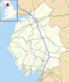
Bridekirk is a small village in Cumbria, England. It's located in the Cumberland area. The village is about 2 miles (3.2 km) north of the Derwent river. It's also close to the town of Cockermouth, which is just south of the river. Bridekirk is very near the Lake District National Park, only about 1 mile (1.6 km) away by road. It's also not far from the old Maryport and Carlisle Railway line.
Bridekirk is part of a larger area called a civil parish. This parish includes Bridekirk village itself, plus the nearby villages of Tallentire and Dovenby. In the past, the area known as Bridekirk was much bigger. It used to include places like Great Broughton and Little Broughton. But over time, these areas became their own separate parishes.
Contents
What is Bridekirk Like?
People Living in Bridekirk
In 2001, the Bridekirk Civil Parish had 636 people living in it. There were 246 homes in total.
Most adults in Bridekirk Parish (people aged 16 to 74) are "economically active." This means they have jobs or are looking for work. In 2001, about 335 people were economically active. Around 125 people in the same age group were "economically inactive," meaning they were not working or looking for work. This could be because they were students, retired, or caring for family.
Where Did the Name Bridekirk Come From?
The name Bridekirk has a cool meaning! It means "the church of St Bride" or St Bridget. The word Kirkja is an old word from Old Norse (an ancient language) that means "church." So, Bridekirk is named after a church dedicated to St Bridget.
A Look Back in Time: Bridekirk's History
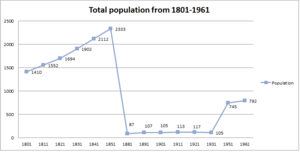
The first time the government counted how many people lived in Bridekirk was in 1801. This was part of a big count across England, Wales, and Scotland. In 1801, Bridekirk had about 1,400 people.
The first records of how many houses were in Bridekirk came in 1831. Back then, there were 424 houses. From 1851 to 1881, the number of houses seemed to drop a lot. It went from over 500 in 1851 to only 26 in 1881. This big change happened because the way they counted the population changed. Instead of counting all the smaller towns that were once part of Bridekirk's parish, they only counted the village of Bridekirk itself.
Bridekirk's boundaries have changed a few times.
- In 1887, the town of Dovenby became part of the parish.
- In 1934, Bridekirk's area became smaller when two towns were no longer included.
Jobs in Bridekirk
Jobs in the Past (1831)
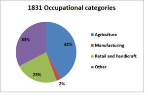
A long time ago, in 1831, most people in Bridekirk worked in farming. This included farmers and farm workers. Many also worked in "retail and handicrafts," which means they made and sold goods in small businesses. Not many people worked in "manufacturing" back then. This is because manufacturing usually means big factories, and Bridekirk was a small town without many large factories.
Compared to today, Bridekirk had many more jobs in farming and making things.
Jobs Today
Today, the types of jobs in Bridekirk Parish are quite different.
- About 33.7% of people (113 people) work in "extractive and manufacturing industries." This means jobs like mining, quarrying, or making products.
- A much larger group, about 66.5% (223 people), work in "service industries." These are jobs that provide services, like teaching, healthcare, shops, or tourism.
Other types of jobs include:
- Managerial and professional jobs: 55.8% (187 people). These are often jobs that require special training or education.
- Small business owners or self-employed: 22.3% (75 people).
- Lower supervisory and technical jobs: 6.5% (22 people).
- Unemployed: 2% (7 people).
St Bridget's Church
St Bridget's Church is a very old and important building in Bridekirk. A wooden church was first built here a very long time ago. Then, in 1130, a stone church was built.
Before the 1500s, when many monasteries were closed down in England, St Bridget's Church was owned by a place called Gisborough Priory. Over the years, the church building got old and worn out. So, in 1868, a new church was built by architects Corey and Ferguson. They built it next to the old church's ruins.
The new church used some parts from the old one. For example, the decorative stone above the south door (called a tympanum) and the archway are from the original church. The new church was built in a style called "neo-Norman," which looks like old Norman buildings.
Inside the church, there's a special font from the 12th century. It's probably from the very first stone church! This font is in amazing condition for its age. It was carved by someone named Richard of Durham. It even has an old runic message carved into it that says, "Richard he me wrought, and to this beauty me brought." The font has beautiful carvings showing patterns and stories like Adam and Eve, and Christ's baptism.
Outside the church, near where the old chapel used to be, you can find some very old tombstones and coffin lids. St Bridget's was not just a regular church in medieval times; it was a very important "Minster Church" that received many valuable gifts.
How Bridekirk is Governed
Bridekirk is part of the Workington area for the UK Parliament. This means that people in Bridekirk vote for a Member of Parliament (MP) to represent them in the national government. The current MP for Workington is Mark Jenkinson from the Conservative Party.
For local matters, Bridekirk is part of the Cumberland unitary authority area. A unitary authority is a type of local government that handles most local services.
Bridekirk also has its own local council called the Bridekirk Parish Council. This council meets once a month at Bridekirk Dovenby School. They usually meet on the second Thursday of the month at 7:30 PM. The Parish Council has its own councillors who attend these meetings to discuss local issues. Sometimes, the MP for Workington and other local councillors are invited to attend as well. You can find out what happens at these meetings on the Parish Council website.
Getting Around Bridekirk
In the past, Bridekirk had a local bus service. However, due to budget cuts, this service has stopped. Buses still run past Dovenby on the main road, and close to Bridekirk on the main road towards Carlisle.
The closest main road is the A595. This road goes directly north-east to Carlisle, which is about 24.7 miles (39.8 km) from Bridekirk. If you want to use public transport to get to Carlisle, you can take a bus from Cockermouth to Maryport. From Maryport, it takes about 45 minutes on the old Maryport and Carlisle Railway route to reach Carlisle.
Bridekirk's Weather
| Climate data for Bridekirk, Cumbria, England | |||||||||||||
|---|---|---|---|---|---|---|---|---|---|---|---|---|---|
| Month | Jan | Feb | Mar | Apr | May | Jun | Jul | Aug | Sep | Oct | Nov | Dec | Year |
| Mean daily maximum °C (°F) | 6 (43) |
7 (45) |
9 (48) |
11 (52) |
15 (59) |
17 (63) |
19 (66) |
19 (66) |
16 (61) |
13 (55) |
9 (48) |
7 (45) |
12 (54) |
| Mean daily minimum °C (°F) | 2 (36) |
2 (36) |
3 (37) |
4 (39) |
6 (43) |
9 (48) |
12 (54) |
11 (52) |
9 (48) |
7 (45) |
4 (39) |
2 (36) |
6 (43) |
| Average precipitation cm (inches) | 9.39 (3.70) |
8 (3.1) |
7.33 (2.89) |
5.41 (2.13) |
5.62 (2.21) |
6.38 (2.51) |
6.14 (2.42) |
7.15 (2.81) |
8.32 (3.28) |
11.09 (4.37) |
9.85 (3.88) |
10.47 (4.12) |
95.15 (37.42) |
| Source: www.bing.com | |||||||||||||
 | DeHart Hubbard |
 | Wilma Rudolph |
 | Jesse Owens |
 | Jackie Joyner-Kersee |
 | Major Taylor |


