Bridgeport, Washington facts for kids
Quick facts for kids
Bridgeport
|
|
|---|---|
| Bridgeport, Washington | |

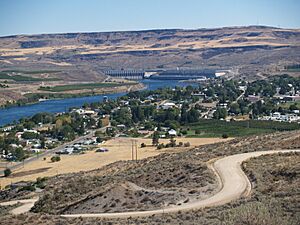
Bridgeport, Washington, with Chief Joseph Dam in the background
|
|

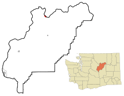
Location of Bridgeport, Washington
|
|
| Country | United States |
| State | Washington |
| County | Douglas |
| Area | |
| • Total | 1.30 sq mi (3.36 km2) |
| • Land | 1.07 sq mi (2.78 km2) |
| • Water | 0.23 sq mi (0.59 km2) |
| Elevation | 850 ft (259 m) |
| Population
(2020)
|
|
| • Total | 2,141 |
| • Density | 1,647/sq mi (637.2/km2) |
| Time zone | UTC-8 (Pacific (PST)) |
| • Summer (DST) | UTC-7 (PDT) |
| ZIP code |
98813
|
| Area code | 509 |
| FIPS code | 53-07870 |
| GNIS feature ID | 1503541 |
| Website | City of Bridgeport |
Bridgeport is a small city located in Douglas County, Washington. It's a part of the larger Wenatchee area. In 2020, about 2,141 people lived here. Bridgeport is special because it's very close to the huge Chief Joseph Dam.
Contents
History of Bridgeport
The area where Bridgeport now stands was first settled in the late 1800s. It was originally called Westfield. Some of the very first people to live here were Chinese miners. They came to find gold along the Columbia River.
In 1892, some developers bought the town. They renamed it Bridgeport. This new name came from their hometown, Bridgeport, Connecticut. The city of Bridgeport officially became a city on March 21, 1910. A big boost for the city happened when the massive Foster Creek Dam was built nearby. This dam was later renamed the Chief Joseph Dam.
Geography of Bridgeport
Bridgeport is located at 48°0′22″N 119°40′18″W / 48.00611°N 119.67167°W.
The city covers about 1.05 square miles (2.72 square kilometers) of land. Bridgeport has more than 1.5 miles of Columbia River waterfront within its city limits. People are working to develop these waterfront areas.
The Chief Joseph Dam is located about 1.5 miles upstream from Bridgeport. Bridgeport is right next to the border of Okanogan County. They are connected by Rufus Woods Lake. A popular place for tourists is just north of the city in Okanogan County.
Climate and Weather
Bridgeport has seen some very hot weather! It shares the record for the highest June temperature ever recorded in Washington state. This was 113 degrees Fahrenheit (45 degrees Celsius). This record was set in June 2015.
Bridgeport broke its own record six years later. On June 29, 2021, the temperature reached an amazing 115 degrees Fahrenheit (46 degrees Celsius).
Population and People
| Historical population | |||
|---|---|---|---|
| Census | Pop. | %± | |
| 1910 | 431 | — | |
| 1920 | 337 | −21.8% | |
| 1930 | 305 | −9.5% | |
| 1940 | 320 | 4.9% | |
| 1950 | 802 | 150.6% | |
| 1960 | 876 | 9.2% | |
| 1970 | 952 | 8.7% | |
| 1980 | 1,174 | 23.3% | |
| 1990 | 1,498 | 27.6% | |
| 2000 | 2,059 | 37.4% | |
| 2010 | 2,409 | 17.0% | |
| 2020 | 2,141 | −11.1% | |
| U.S. Decennial Census | |||
In 2010, about 2,409 people lived in Bridgeport. There were 673 households in the city. Many households had children living with them. The average household had about 3.58 people.
The average age of people in Bridgeport was 25.6 years old. A large part of the population, about 37.4%, was under 18 years old.
Famous People
- Clyde Pangborn, a pioneering aviator (someone who flies airplanes)
See also
 In Spanish: Bridgeport (Washington) para niños
 | Delilah Pierce |
 | Gordon Parks |
 | Augusta Savage |
 | Charles Ethan Porter |


