
Bridger Jack Butte facts for kids
Quick facts for kids Bridger Jack Butte |
|
|---|---|

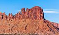
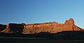
Bridger Jack Butte, northeast aspect
|
|
| Highest point | |
| Elevation | 5,890 ft (1,800 m) |
| Prominence | 280 ft (85 m) |
| Isolation | 1.62 mi (2.61 km) |
| Parent peak | Cotton Benchmark (6,747 ft) |
| Geography | |

Bridger Jack Butte
Location in Utah

Bridger Jack Butte
Location in the United States
|
|
| Location | Bears Ears National Monument San Juan County, Utah, US |
| Parent range | Colorado Plateau |
| Topo map | USGS Harts Point South |
| Geology | |
| Age of rock | Late Triassic |
| Type of rock | Wingate Sandstone |
| Climbing | |
| First ascent | 1983 |
| Easiest route | Wild Flower class 5.10+ climbing |
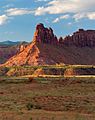
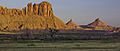
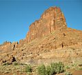
Bridger Jack Butte is a tall, flat-topped rock formation called a butte. It is made of sandstone and is located in Bears Ears National Monument in Utah, USA. This impressive butte stands at the northern end of Bridger Jack Mesa. It rises 5,890 feet (1,795 meters) high. It also towers over 700 feet (213 meters) above the ground in Lavender Canyon.
Bridger Jack Butte is about four miles southeast of Sixshooter Peaks. You can see it from State Route 211. This road runs between Newspaper Rock and Canyonlands National Park. The name "Bridger Jack" comes from a Paiute medicine man.
Contents
What is Bridger Jack Butte Made Of?
Bridger Jack Butte is made of a type of rock called Wingate Sandstone. This sandstone is very hard and fine-grained. It was formed about 200 million years ago, during the Late Triassic period. Back then, this area was covered by huge sand dunes, similar to a desert. Over millions of years, these sand dunes turned into rock.
The Wingate Sandstone forms steep cliffs. It sits on top of softer rock layers. Rainwater flows off the butte and into Indian Creek. This creek eventually joins the Colorado River.
Climbing at Bridger Jack Butte
Bridger Jack Butte is a popular spot for climbing in the Indian Creek climbing area. The very first time someone successfully climbed to the top of Bridger Jack Butte was on June 12, 1983. The climbers were Ed Webster, Leonard Coyne, and Ellen Figi. They used a route called Wild Flower.
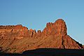
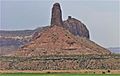
Near the butte, there are other rock towers called the "Bridger Jacks." These towers are on the ridge that connects the mesa to the butte. They have fun names like "King of Pain," "Hummingbird Spire," "Sunflower Tower," "Easter Island," and "Thumbelina."
Some climbing routes on the Bridger Jacks include:
- Wild Flower class 5.10a (3 pitches)
- Sparkling Touch - class 5.11
- The Kokanee Corner - class 5.13+
- Hydrophobic coyote - class 5.10-
- Rites of Passage - class 5.11+
Weather at Bridger Jack Butte
The best times to visit Bridger Jack Butte are in the spring and fall. The weather is usually mild then. The area has a Cold semi-arid climate. This means that the coldest month has an average temperature below 32°F (0°C). Also, at least half of the yearly rain and snow falls during spring and summer.
This desert climate gets less than 10 inches (250 mm) of rain each year. Snowfall in the winter is usually light.
Images for kids
-
Bridger Jacks and Butte, from east
-
Bridger Jacks and Butte, from east
-
Northwest aspect
-
Bridger Jack Butte, north aspect
-
Bridger Jack Mesa and Butte (right)
-
Bridger Jack Butte (left) with Sixshooter Peaks (right)
-
.jpg)
.jpg)


.jpg)


