
Sixshooter Peaks facts for kids
Quick facts for kids Sixshooter Peaks |
|
|---|---|

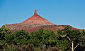
Six-shooter Peaks, east aspect
|
|
| Highest point | |
| Elevation | 6,379 ft (1,944 m) |
| Prominence | 679 ft (207 m) |
| Isolation | 4.37 mi (7.03 km) |
| Geography | |

Sixshooter Peaks
Location in Utah

Sixshooter Peaks
Location in the United States
|
|
| Location | Bears Ears National Monument San Juan County, Utah, US |
| Parent range | Colorado Plateau |
| Topo map | USGS North Six-shooter Peak and South Six-shooter Peak |
| Geology | |
| Age of rock | Late Triassic |
| Type of rock | Wingate Sandstone |
| Climbing | |
| First ascent | 1962 |
| Easiest route | class 5.7 climbing |
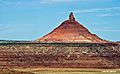
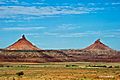
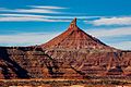
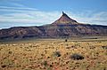
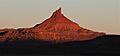
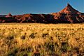
The Sixshooter Peaks are two amazing sandstone mountains. You can find them in Bears Ears National Monument in San Juan County, Utah, US. The taller peak is North Sixshooter Peak, which is 6,379 feet (1,944 meters) high. South Sixshooter Peak is 6,154 feet tall. These two peaks are about 1.5 miles (2 km) apart.
These tall, flat-topped mountains, called buttes, rise almost 1,400 feet (425 meters) from the ground. They are important landmarks you can see from State Route 211. This road runs between Newspaper Rock and the Needles District of Canyonlands National Park. The peaks are just outside the park boundary. They are also about four miles northwest of Bridger Jack Butte. People call them by a few different names, like "North Six-Shooter Peak" or "Six Shooter Peaks." They got their name because they look like two revolvers (old-fashioned guns) pointing up at the sky.
Contents
Geology: How the Peaks Formed
The Sixshooter Peaks are made of strong, fine-grained Wingate Sandstone. This sandstone formed from sand dunes that were blown by wind about 200 million years ago. This was during a time called the Late Triassic period. The Wingate sandstone forms steep cliffs. It sits on top of softer layers of rock called the Chinle Formation. These softer layers create rounded hills below the tall sandstone towers. Below the Chinle Formation is another rock layer called the Moenkopi Formation.
Water from rain and snow flows off the peaks. This runoff goes into nearby Indian Creek. Indian Creek is part of the larger Colorado River system.
Climbing the Sixshooter Peaks
Many people enjoy climbing these peaks. The first ascent (first time someone climbed to the top) of North Sixshooter Peak happened on April 14, 1962. Maurice Horn, Huntley Ingalls, and Steve Komito were the climbers. They used a path called the Southwest Chimney. South Sixshooter Peak was first climbed in September 1969. Billy Roos, Burnham Arndt, and Denver Collins made that climb. The south peak is a popular climb for beginners. It has one of the easiest routes in the Indian Creek climbing area.
North Sixshooter Peak Climbing Routes
- Talk Dusty To Me class 5.9+
- Southeast Chimney Route class 5.10 A1
- Liquid Sky class 5.11+
- Shadows Route class 5.10
- Gunsmoke class 5.11+
- Lightning Bolt Cracks class 5.11-
- Perfect Hands All the Way class 5.11+
- Pratt's Crack class 5.10
South Sixshooter Peak Climbing Routes
- South Face routes class 5.6 to 5.11
Climate Around the Peaks
The best times to visit the Sixshooter Peaks are spring and fall. The area has a Cold semi-arid climate. This means the coldest month has an average temperature below 32 °F (0 °C). Also, at least half of the yearly rain and snow falls during spring and summer. This desert climate gets less than 10 inches (250 mm) of rain each year. Snowfall is usually light in the winter.
Gallery
-
North Sixshooter Peak, northeast aspect
-
South Sixshooter Peak
-
South Sixshooter (left), and North Peak to right
-
North Sixshooter Peak, northeast aspect
-
North Sixshooter Peak
-
North Sixshooter Peak at sunrise
-
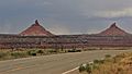
Sixshooter Peaks from State Route 211
-


.jpg)
.jpg)


