
Bristol Bay Borough, Alaska facts for kids
Quick facts for kids
Bristol Bay Borough
|
||
|---|---|---|

|
||
|
||

Location within the U.S. state of Alaska
|
||
.svg) Alaska's location within the U.S. |
||
| Country | ||
| State | ||
| Incorporated | October 2, 1962 | |
| Named for | Bristol Bay | |
| Seat | Naknek | |
| Largest community | Naknek | |
| Area | ||
| • Total | 888 sq mi (2,300 km2) | |
| • Land | 504 sq mi (1,310 km2) | |
| • Water | 384 sq mi (990 km2) 43.2%% | |
| Population
(2020)
|
||
| • Total | 843 | |
| • Density | 0.9493/sq mi (0.3665/km2) | |
| Time zone | UTC−9 (Alaska) | |
| • Summer (DST) | UTC−8 (ADT) | |
| Congressional district | At-large | |

Bristol Bay Borough is a special kind of county, called a "borough," in the state of Alaska. It is located right on Bristol Bay. In 2020, about 843 people lived here. This makes it one of the least populated boroughs in Alaska. The main town, or "borough seat," is Naknek. There are no other official towns inside the borough.
Bristol Bay Borough was created in 1962. It was the very first borough in Alaska! It is also one of the smallest boroughs. It mostly covers the land around Naknek on the coast and King Salmon further inland.
Contents
Geography
The borough covers about 888 square miles (2,300 square kilometers) in total. About 504 square miles (1,305 square kilometers) is land. The other 384 square miles (995 square kilometers), which is 43.2% of the area, is water.
Neighboring Areas
Bristol Bay Borough shares borders with these other areas:
- Lake and Peninsula Borough, Alaska (to the east, north, and south)
- Dillingham Census Area, Alaska (to the west)
Protected Natural Areas
Part of a large national park is found within the borough:
- Katmai National Park and Preserve (a part of it)
- Katmai Wilderness (also a part of it)
People Living Here (Demographics)
The number of people living in Bristol Bay Borough has changed over the years. Here's how the population has looked:
| Historical population | |||
|---|---|---|---|
| Census | Pop. | %± | |
| 1970 | 1,147 | — | |
| 1980 | 1,094 | −4.6% | |
| 1990 | 1,410 | 28.9% | |
| 2000 | 1,258 | −10.8% | |
| 2010 | 997 | −20.7% | |
| 2020 | 843 | −15.4% | |
| 2023 (est.) | 844 | −15.3% | |
| U.S. Decennial Census 1900-1990 1990-2000 2010-2018 |
|||
In the year 2000, there were 1,258 people living in the borough. These people lived in 490 homes, and 300 of those were families. On average, there were about 2 people living per square mile.
Most people identified as White (52.54%) or Native American (43.72%). A small number of people were Black or African American (0.56%), Asian (0.24%), or Pacific Islander (0.48%). Some people (2.38%) were from two or more races. About 0.56% of the people were Hispanic or Latino.
In 2000, about 38.2% of homes had children under 18 living there. About 49.2% were married couples. The average home had 2.57 people, and the average family had 3.33 people.
The median age of people in the borough was 36 years old. This means half the people were younger than 36, and half were older. About 31.3% of the people were under 18.
Communities
These are the main communities in Bristol Bay Borough:
- King Salmon
- Naknek (This is the borough seat, or main town)
- South Naknek
Images for kids
-
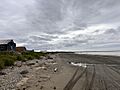
The Bering Sea and Kvichak Bay, at Pederson Point.
-
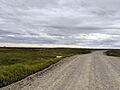
Tundra outside Naknek.
-

Bristol Bay Borough Fire and EMS.
-
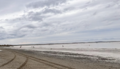
Kvichak Bay at low tide, with fishermen in the distance. Fishing is a major industry in the Bristol Bay Borough.


See also
 In Spanish: Borough de la Bahía de Bristol para niños
