King Salmon, Alaska facts for kids
Quick facts for kids
King Salmon, Alaska
|
|
|---|---|

Naknek River in King Salmon
|
|

Location of King Salmon, Alaska
|
|
| Country | United States |
| State | Alaska |
| Borough | Bristol Bay |
| Area | |
| • Total | 169.66 sq mi (439.41 km2) |
| • Land | 168.20 sq mi (435.65 km2) |
| • Water | 1.45 sq mi (3.76 km2) |
| Population
(2020)
|
|
| • Total | 307 |
| • Density | 1.83/sq mi (0.70/km2) |
| Time zone | UTC−9 (Alaska (AKST)) |
| • Summer (DST) | UTC−8 (AKDT) |
| ZIP code |
99613
|
| Area code(s) | 907 |
| FIPS code | 02-39630 |
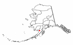
King Salmon is a small community in Bristol Bay Borough in the U.S. state of Alaska. It is known as a census-designated place (CDP), which means it's a specific area identified by the census bureau. King Salmon is located about 284 miles (457 km) southwest of Anchorage.
In 2020, the population of King Salmon was 307 people. This was a bit less than its population of 374 in 2010. King Salmon is also a gateway to the amazing Katmai National Park and Preserve, famous for its bears and volcanoes. While it's the main town for the nearby Lake and Peninsula Borough, it's not the main town for its own borough; that's Naknek.
Contents
Geography of King Salmon
King Salmon is found on the north side of the Naknek River. This river is on the Alaska Peninsula, which is a long piece of land stretching out into the Pacific Ocean. The community is about 16 miles (26 km) upriver from Naknek, and it's also close to Naknek Lake.
The entire area of King Salmon is quite large, covering about 171 square miles (443 square kilometers). Most of this area, about 169.6 square miles (439.3 square kilometers), is land. The rest, about 1.4 square miles (3.6 square kilometers), is water.
King Salmon's Climate
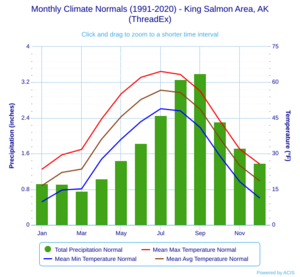
King Salmon has a type of weather called a subarctic climate. This means it has very cold, long winters and short, cool summers. Even though it's far north at 58° North, its temperatures are not as extreme as some other very cold places.
Winter temperatures in King Salmon are still milder than in some parts of the central United States. The town is just south of where sporadic permafrost (ground that stays frozen for a long time) can be found. It's also protected from the very wet weather systems that come from the Pacific Ocean.
The coldest temperature ever recorded in King Salmon was -48°F (-44°C) in January 1989. The warmest was 89°F (32°C) in July 2019. Winter days can be very cold, especially when winds blow in from the interior of Alaska. Even in summer, warm nights are rare.
| Climate data for King Salmon, Alaska (King Salmon Airport), 1991–2020 normals, extremes 1917–present | |||||||||||||
|---|---|---|---|---|---|---|---|---|---|---|---|---|---|
| Month | Jan | Feb | Mar | Apr | May | Jun | Jul | Aug | Sep | Oct | Nov | Dec | Year |
| Record high °F (°C) | 53 (12) |
57 (14) |
59 (15) |
69 (21) |
85 (29) |
88 (31) |
89 (32) |
84 (29) |
76 (24) |
67 (19) |
56 (13) |
54 (12) |
89 (32) |
| Mean maximum °F (°C) | 44.2 (6.8) |
44.8 (7.1) |
46.7 (8.2) |
57.4 (14.1) |
70.3 (21.3) |
75.5 (24.2) |
77.9 (25.5) |
74.6 (23.7) |
65.9 (18.8) |
56.6 (13.7) |
47.6 (8.7) |
44.4 (6.9) |
79.6 (26.4) |
| Mean daily maximum °F (°C) | 23.5 (−4.7) |
29.5 (−1.4) |
31.8 (−0.1) |
44.5 (6.9) |
55.2 (12.9) |
62.1 (16.7) |
64.6 (18.1) |
63.3 (17.4) |
56.3 (13.5) |
43.8 (6.6) |
31.9 (−0.1) |
25.7 (−3.5) |
44.3 (6.8) |
| Daily mean °F (°C) | 16.6 (−8.6) |
22.1 (−5.5) |
23.5 (−4.7) |
36.0 (2.2) |
45.6 (7.6) |
52.8 (11.6) |
56.7 (13.7) |
55.7 (13.2) |
48.7 (9.3) |
36.4 (2.4) |
25.0 (−3.9) |
18.6 (−7.4) |
36.5 (2.5) |
| Mean daily minimum °F (°C) | 9.8 (−12.3) |
14.7 (−9.6) |
15.2 (−9.3) |
27.6 (−2.4) |
36.1 (2.3) |
43.5 (6.4) |
48.9 (9.4) |
48.0 (8.9) |
41.0 (5.0) |
29.0 (−1.7) |
18.2 (−7.7) |
11.4 (−11.4) |
28.6 (−1.9) |
| Mean minimum °F (°C) | −22.5 (−30.3) |
−17.6 (−27.6) |
−10.8 (−23.8) |
8.4 (−13.1) |
24.9 (−3.9) |
32.3 (0.2) |
38.7 (3.7) |
34.5 (1.4) |
24.6 (−4.1) |
8.9 (−12.8) |
−7.6 (−22.0) |
−18.8 (−28.2) |
−29.5 (−34.2) |
| Record low °F (°C) | −48 (−44) |
−43 (−42) |
−42 (−41) |
−19 (−28) |
4 (−16) |
27 (−3) |
31 (−1) |
25 (−4) |
15 (−9) |
−12 (−24) |
−28 (−33) |
−38 (−39) |
−48 (−44) |
| Average precipitation inches (mm) | 0.93 (24) |
0.91 (23) |
0.76 (19) |
1.04 (26) |
1.44 (37) |
1.83 (46) |
2.46 (62) |
3.26 (83) |
3.40 (86) |
2.31 (59) |
1.72 (44) |
1.38 (35) |
21.44 (545) |
| Average snowfall inches (cm) | 8.6 (22) |
7.2 (18) |
7.2 (18) |
4.4 (11) |
0.6 (1.5) |
0.0 (0.0) |
0.0 (0.0) |
0.0 (0.0) |
0.0 (0.0) |
2.5 (6.4) |
6.7 (17) |
10.2 (26) |
47.4 (120) |
| Average precipitation days (≥ 0.01 in) | 10.0 | 10.1 | 9.2 | 10.8 | 12.3 | 14.4 | 16.2 | 17.1 | 18.0 | 14.7 | 13.2 | 12.9 | 158.9 |
| Average snowy days (≥ 0.1 in) | 8.2 | 8.3 | 8.1 | 4.8 | 0.7 | 0.0 | 0.0 | 0.0 | 0.1 | 2.7 | 7.4 | 9.9 | 50.2 |
| Average relative humidity (%) | 75.9 | 72.8 | 72.8 | 71.8 | 70.2 | 73.5 | 77.5 | 79.7 | 78.8 | 79.3 | 81.0 | 76.7 | 75.8 |
| Average dew point °F (°C) | 9.1 (−12.7) |
7.9 (−13.4) |
15.1 (−9.4) |
22.6 (−5.2) |
32.4 (0.2) |
40.8 (4.9) |
46.8 (8.2) |
46.9 (8.3) |
40.5 (4.7) |
26.6 (−3.0) |
17.8 (−7.9) |
10.2 (−12.1) |
26.4 (−3.1) |
| Source: NOAA (relative humidity and dew point 1961–1990) | |||||||||||||
Population of King Salmon
| Historical population | |||
|---|---|---|---|
| Census | Pop. | %± | |
| 1960 | 227 | — | |
| 1970 | 202 | −11.0% | |
| 1980 | 545 | 169.8% | |
| 1990 | 696 | 27.7% | |
| 2000 | 442 | −36.5% | |
| 2010 | 374 | −15.4% | |
| 2020 | 307 | −17.9% | |
| U.S. Decennial Census | |||
King Salmon first appeared in the U.S. Census in 1960. Back then, it was just a small village. By 1980, it became a census-designated place (CDP).
In the year 2000, there were 442 people living in King Salmon. These people lived in 196 households, and 105 of those were families. About 30% of the households had children under 18 living there. Many different groups of people call King Salmon home, including White, Black, Native American, and Asian residents. Some people also identify with two or more races.
The average age of people in King Salmon in 2000 was 38 years old. About 26% of the population was under 18. This shows a mix of young people, adults, and older residents living in the community.
Amazing Parks Nearby
King Salmon is a great place for nature lovers! It's very close to:
This national park is famous for its brown bears, which gather at Brooks Falls to catch salmon. It's also known for its volcanic landscapes, including the Valley of Ten Thousand Smokes.
History of King Salmon
King Salmon has an interesting history, especially tied to its role in transportation and defense.
Early Development
In the 1930s, the U.S. government built a special tower here to help airplanes navigate. This tower was the start of what would become King Salmon. When World War II began, the U.S. Army Air Forces built an air base around this tower. It was important for military flights during the war.
Growth and Community
After the war, in the 1940s and 1950s, the U.S. Army Corps of Engineers built a 16-mile (25 km) road connecting King Salmon to Naknek. Other government groups, like the National Park Service and the United States Weather Bureau, also set up offices here. In 1956, the King Salmon Inn opened, giving visitors a place to stay.
Today, King Salmon is a busy center for government services and transportation. It's also very important for the fishing industry, especially for catching red salmon and for sport fishing.
Modern Role
The Air Force base closed in 1994. Now, the King Salmon Airport is open to the public. It helps people travel to and from this remote part of Alaska. King Salmon is also home to a special science project called the Super Dual Auroral Radar Network. This network helps scientists study the aurora borealis (Northern Lights) and space weather.
See also
 In Spanish: King Salmon para niños
 | Delilah Pierce |
 | Gordon Parks |
 | Augusta Savage |
 | Charles Ethan Porter |


