1607 Bristol Channel floods facts for kids
The Bristol Channel floods happened on January 30, 1607. This huge flood caused a lot of damage. Many people lost their lives, and large areas of farmland were ruined. Animals were also lost. Experts believe the flood was caused by a powerful storm surge, not a tsunami. This is because of how high the tides were, the weather, and similar floods in other parts of the UK on the same day.
Contents
What Happened During the 1607 Flood?
On January 30, 1607, around noon, the coasts of the Bristol Channel were hit by very high floods. These floods broke through the walls built to protect the land. Low-lying areas in Devon, Somerset, Gloucestershire, and South Wales were covered in water.
The damage was especially bad on the Welsh side. It stretched from Laugharne to Chepstow. Cardiff was the most affected town. The foundations of St Mary's Church there were destroyed.
It is thought that over 2,000 people drowned. Houses and even whole villages were swept away. About 200 square miles (520 square kilometers) of farmland were flooded. Many farm animals were lost, which badly hurt the local economy.
The flood also reached the coast of Devon and the Somerset Levels. It went as far inland as Glastonbury Tor, which is 14 miles (23 km) from the coast. The sea wall at Burnham-on-Sea broke. Water then flowed over the low-lying fields and moors.
Thirty villages in Somerset were affected. For example, Brean was "swallowed up." Seven out of nine houses there were destroyed, and 26 people died. The Church of All Saints at Kingston Seymour was filled with water. It was 5 feet (1.5 meters) deep for ten days. A mark still shows the water reached 25 feet 5 inches (7.74 meters) above sea level.
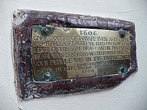
Many special plaques still exist today. They are often 8 feet (2.4 meters) above sea level. These plaques show how high the water rose on the sides of churches that survived. For example, at Goldcliff near Newport, there is a small brass plaque inside the church. It is about 3 feet (0.9 meters) above the ground. This plaque marks the flood's height. It says the year was 1606. This is because the new year started on March 25 back then, according to the Julian calendar. The financial loss in that area was about £5,000.
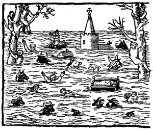
A pamphlet from that time, called God's warning to the people of England, talked about the flood. A writer named William Jones described how people tried to escape. He wrote that the water came so fast that in less than five hours, most low-lying areas were flooded. Many people were "devoured" by the water. Some people climbed into tall trees and stayed there for days without food. They watched their homes and families being swept away.
What Caused the Flood?
Experts have studied the 1607 flood to understand its cause. There are two main ideas: a storm surge or a tsunami.
Storm Surge Hypothesis
A storm surge is when strong winds from a storm push sea water towards the coast. This makes the sea level much higher than normal. This is similar to the 1953 floods in East Anglia, which were caused by a storm surge.
In 2006, researchers Horsburgh and Horritt showed that the tides and weather in 1607 could have caused such a big surge. On January 30, 1607, there was an extremely high tide in the Bristol Channel. It reached 7.86 meters (25.8 feet). There was also a strong south-westerly gale (a very strong wind). This storm caused flooding in other parts of the UK on the same day. This supports the idea of a storm surge.
Tsunami Hypothesis
Some researchers, like Professor Simon Haslett and Ted Bryant, thought the flood might have been a tsunami. A tsunami is a giant ocean wave usually caused by an underwater earthquake. They read old eyewitness accounts that described the flood.
The British Geological Survey suggested that a tsunami could have been caused by an earthquake. This earthquake would have happened on a known fault (a crack in the Earth's crust) off the coast of southwest Ireland. One old report mentioned an earthquake on the morning of the flood. However, other sources say this earthquake happened a few months later.
Haslett and Bryant found some things that made them think it was a tsunami. They found huge rocks that had been moved far up the beach. They also found a layer of sand, shells, and stones up to 8 inches (20 cm) thick in the mud. This layer was found from Devon to Gloucestershire and the Gower Peninsula. They also saw rock erosion that looked like it was caused by very fast-moving water. The BBC show Timewatch explored this idea in 2005.
However, Horsburgh and Horritt argued against the tsunami idea. They said that those who thought it was a tsunami did not fully understand how much water and damage a storm surge can cause. They also pointed out that there was flooding on the other side of the country on the same day. A tsunami would likely have affected West Wales, Cornwall, or southern Ireland, but there is no evidence of this. Also, old reports say the flood lasted for five hours. This is more typical of a storm surge than a tsunami, which usually hits quickly.
Could It Happen Again?
The chance of a similar flood happening soon is considered low. However, if a flood like this happened today, it could cause huge damage. The cost to homes, businesses, and farms could be between £7 billion and £13 billion. There has also been worry that the nuclear power stations at Hinkley Point and Oldbury could be at risk.
On January 30, 2007, which was 400 years after the flood, BBC Somerset looked at the causes. They also asked if such a flood could happen again in the county.
 | William M. Jackson |
 | Juan E. Gilbert |
 | Neil deGrasse Tyson |


