Brooklawn, New Jersey facts for kids
Quick facts for kids
Brooklawn, New Jersey
|
||
|---|---|---|
|
Borough
|
||
|
||

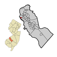
Location of Brooklawn in Camden County highlighted in red (right). Inset map: Location of Camden County in New Jersey highlighted in orange (left).
|
||

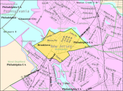
Census Bureau map of Brooklawn, New Jersey
|
||
| Country | ||
| State | ||
| County | Camden | |
| Incorporated | March 11, 1924 | |
| Government | ||
| • Type | Borough | |
| • Body | Borough Council | |
| Area | ||
| • Total | 0.53 sq mi (1.37 km2) | |
| • Land | 0.49 sq mi (1.27 km2) | |
| • Water | 0.04 sq mi (0.11 km2) 7.74% | |
| Area rank | 546th of 565 in state 32nd of 37 in county |
|
| Elevation | 20 ft (6 m) | |
| Population
(2020)
|
||
| • Total | 1,815 | |
| • Estimate
(2023)
|
1,813 | |
| • Rank | 493rd of 565 in state 32nd of 37 in county |
|
| • Density | 3,715.7/sq mi (1,434.6/km2) | |
| • Density rank | 179th of 565 in state 22nd of 37 in county |
|
| Time zone | UTC−05:00 (Eastern (EST)) | |
| • Summer (DST) | UTC−04:00 (Eastern (EDT)) | |
| ZIP Code |
08030
|
|
| Area code(s) | 856 exchanges: 456, 742, 931, 933 | |
| FIPS code | 3400708170 | |
| GNIS feature ID | 0885172 | |
Brooklawn is a small town, called a borough, located in Camden County, New Jersey. In 2020, about 1,815 people lived there. The town's name comes from its pretty location with brooks and lawns.
Brooklawn became an official borough on March 11, 1924. It was formed from parts of an older area called Centre Township.
Contents
About Brooklawn: Location and Size
Brooklawn is a small place, covering about 0.53 square miles (1.37 square kilometers). Most of this area is land, with a small part being water.
The borough is surrounded by several other towns. These include Bellmawr, Gloucester City, and Mount Ephraim in Camden County. It also borders Westville in Gloucester County.
People and Population in Brooklawn
| Historical population | |||
|---|---|---|---|
| Census | Pop. | %± | |
| 1930 | 1,753 | — | |
| 1940 | 1,919 | 9.5% | |
| 1950 | 2,262 | 17.9% | |
| 1960 | 2,504 | 10.7% | |
| 1970 | 2,870 | 14.6% | |
| 1980 | 2,133 | −25.7% | |
| 1990 | 1,805 | −15.4% | |
| 2000 | 2,354 | 30.4% | |
| 2010 | 1,955 | −16.9% | |
| 2020 | 1,815 | −7.2% | |
| 2023 (est.) | 1,813 | −7.3% | |
| Population sources: 1930–2000 1930 1940–2000 2000 2010 2020 |
|||
How Many People Live Here?
In 2010, there were 1,955 people living in Brooklawn. These people lived in 759 homes, with 516 of them being families. The town had about 3,975 people per square mile.
Who Lives in Brooklawn?
Most people in Brooklawn are White (about 87.88%). There are also Black or African American residents (5.32%) and Asian residents (2.20%). About 6.29% of the population is Hispanic or Latino.
The average home in Brooklawn had about 2.58 people. Families, on average, had 3.08 people.
Age Groups in Brooklawn
About 23.4% of the people in Brooklawn were under 18 years old. About 11.2% were 65 years or older. The average age of people in Brooklawn was 36.9 years.
Education in Brooklawn
Local Schools
Students in Brooklawn from pre-kindergarten through eighth grade go to Alice Costello School. In the 2020–21 school year, this school had 286 students and 29.4 teachers. This means there was about one teacher for every 9.7 students.
High School Students
For ninth through twelfth grades, public school students attend Gloucester City High School. This high school is in Gloucester City. In the 2020–21 school year, it had 587 students and 46.5 teachers.
Technical and Vocational Schools
Students from Brooklawn can also choose to attend the Camden County Technical Schools. These schools offer special training for jobs and careers. They have campuses in Sicklerville and Pennsauken Township.
Getting Around Brooklawn
Roads and Highways
As of 2010, Brooklawn had about 8.19 miles of roads. Most of these roads are kept up by the town itself.
The main highway in Brooklawn is U.S. Route 130. Also, Route 47 ends in Brooklawn. County Route 551 is an important county road here.
Public Transportation
NJ Transit offers bus service from Brooklawn to Philadelphia. Several bus routes, including 401, 402, 408, 410, and 412, serve the borough.
See also
 In Spanish: Brooklawn para niños
 | James Van Der Zee |
 | Alma Thomas |
 | Ellis Wilson |
 | Margaret Taylor-Burroughs |


