Brookston, Minnesota facts for kids
Quick facts for kids
Brookston
|
|
|---|---|

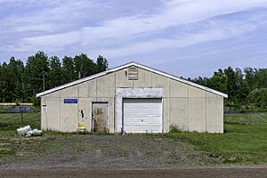
Brookston City Hall
|
|

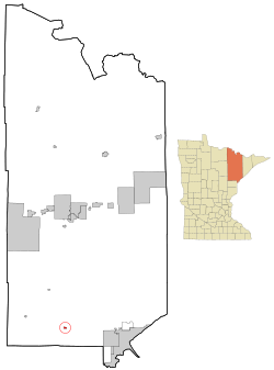
Location of the city of Brookston
within Saint Louis County, Minnesota |
|
| Country | United States |
| State | Minnesota |
| County | Saint Louis |
| Founded | 1905 |
| Incorporated | April 13, 1907 |
| Area | |
| • Total | 0.55 sq mi (1.42 km2) |
| • Land | 0.55 sq mi (1.42 km2) |
| • Water | 0.00 sq mi (0.00 km2) |
| Elevation | 1,230 ft (370 m) |
| Population
(2020)
|
|
| • Total | 118 |
| • Estimate
(2021)
|
116 |
| • Density | 215.72/sq mi (83.25/km2) |
| Time zone | UTC-6 (CST) |
| • Summer (DST) | UTC-5 (CDT) |
| ZIP code |
55711
|
| Area code(s) | 218 |
| FIPS code | 27-08056 |
| GNIS feature ID | 0660884 |
Brookston is a small city in Minnesota, United States. It is located in Saint Louis County. The city sits right along the Saint Louis River.
In 2020, about 118 people lived in Brookston. It is about 27 miles west of Duluth. It is also 17 miles northwest of Cloquet.
Main roads in Brookston include U.S. Highway 2. Saint Louis County Road 31 (CR 31) also runs through the city.
Brookston is part of Culver Township geographically. However, it is a separate city with its own government. The city is also on the northern edge of the Fond du Lac Indian Reservation. It is one of three main centers for the reservation.
Contents
About Brookston's Location
Brookston is a small city in Minnesota. It covers an area of about 0.55 square miles. All of this area is land. There are no large bodies of water within the city limits.
A Look at Brookston's History
Brookston was first planned around 1905. It officially became a village on April 13, 1907. The city's post office opened even earlier, in 1899.
The city was once known by a different name. It was called Stoney Brook Junction. This was because of a railroad station located nearby.
In 1918, a large forest fire destroyed the city. But the people of Brookston worked together. They rebuilt their city after the fire.
Population Over the Years
| Historical population | |||
|---|---|---|---|
| Census | Pop. | %± | |
| 1910 | 160 | — | |
| 1920 | 135 | −15.6% | |
| 1930 | 144 | 6.7% | |
| 1940 | 135 | −6.2% | |
| 1950 | 180 | 33.3% | |
| 1960 | 144 | −20.0% | |
| 1970 | 137 | −4.9% | |
| 1980 | 124 | −9.5% | |
| 1990 | 107 | −13.7% | |
| 2000 | 98 | −8.4% | |
| 2010 | 141 | 43.9% | |
| 2020 | 118 | −16.3% | |
| 2021 (est.) | 116 | −17.7% | |
| U.S. Decennial Census 2020 Census |
|||
Brookston's Population in 2010
In 2010, there were 141 people living in Brookston. These people lived in 38 different homes. About 27 of these homes were families.
The city had 39 housing units in total. Most of the people living in Brookston were White. Some residents were African American or Native American. A small number of people were from two or more races.
About 39.5% of homes had kids under 18. Many homes were married couples living together. Some homes had a female head of household. Others had a male head of household. About 28.9% of homes were not families.
The average age of people in Brookston was 40.3 years old. About 21.3% of residents were under 18. About 20.6% were 65 or older. More males lived in Brookston than females.
See also
 In Spanish: Brookston (Minnesota) para niños
 | Georgia Louise Harris Brown |
 | Julian Abele |
 | Norma Merrick Sklarek |
 | William Sidney Pittman |

