Brownsboro, Texas facts for kids
Quick facts for kids
Brownsboro, Texas
|
|
|---|---|

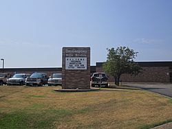
Brownsboro High School
|
|
| Country | United States |
| State | Texas |
| County | Henderson |
| Named for | John "Red" Brown |
| Area | |
| • Total | 2.37 sq mi (6.15 km2) |
| • Land | 2.37 sq mi (6.15 km2) |
| • Water | 0.00 sq mi (0.00 km2) |
| Elevation | 400 ft (100 m) |
| Population
(2020)
|
|
| • Total | 1,212 |
| • Density | 538.98/sq mi (208.13/km2) |
| Time zone | UTC-6 (Central (CST)) |
| • Summer (DST) | UTC-5 (CDT) |
| ZIP code |
75756
|
| Area code(s) | 903, 430 |
| FIPS code | 48-10756 |
| GNIS feature ID | 2409922 |
Brownsboro is a city located in Henderson County, Texas, in the United States. In 2020, about 1,212 people lived there. This was an increase from 1,039 people in 2010. The city is found along Texas State Highway 31.
Contents
History of Brownsboro
Brownsboro was first settled in 1849. A man named John "Red" Brown started the settlement. He ran a special bridge that people had to pay to cross. This bridge was over Kickapoo Creek. It was on the road that led to other towns like Jordan's Saline and Tyler.
By 1860, another person, Henry Cade, built a sawmill and a cotton gin. These were important for making wood and processing cotton. In 1880, a railroad called the St. Louis Southwestern Railway was built through the county. Because of the railroad, the town moved closer to it.
Old Normandy Settlement
Near where Brownsboro is today, there was an older town called Old Normandy. It was started in 1845 by Johan Reinert Reiersen from Kristiansand, Norway. He encouraged people from Norway to come and live in this new community.
However, in the summer of 1847, many settlers became sick and passed away. Because of this, many Norwegian immigrants moved to other areas. They went to places like Four Mile Prairie in Van Zandt County and Prairieville in Kaufman County. These places were also started by Reiersen.
In 1853, a Norwegian Lutheran church and a cemetery were built in Normandy. After some time, the community of Normandy joined with the Brownsboro settlement. The nearby Lutheran church was used as a chapel for the cemetery until the 1920s.
Geography of Brownsboro
Brownsboro is located in the northeastern part of Henderson County. Texas State Highway 31 goes right through the city. If you travel east on this highway, you will reach Tyler in about 19 miles. If you go southwest for about 16 miles, you will arrive at Athens. Athens is the main city and county seat of Henderson County.
The city of Brownsboro covers a total area of about 6.1 square kilometers (2.37 square miles). All of this area is land. Brownsboro is on the south side of the valley of Kickapoo Creek. This creek flows east and eventually joins the Neches River.
People in Brownsboro
| Historical population | |||
|---|---|---|---|
| Census | Pop. | %± | |
| 1940 | 640 | — | |
| 1950 | 518 | −19.1% | |
| 1960 | 507 | −2.1% | |
| 1970 | 474 | −6.5% | |
| 1980 | 582 | 22.8% | |
| 1990 | 545 | −6.4% | |
| 2000 | 796 | 46.1% | |
| 2010 | 1,039 | 30.5% | |
| 2020 | 1,212 | 16.7% | |
| U.S. Decennial Census | |||
In 2020, there were 1,212 people living in Brownsboro. There were 506 households and 421 families. Most people living in Brownsboro were White (72.36%). Other groups included Black or African American (4.79%) and Hispanic or Latino (17.33%).
In 2010, the city had 1,039 people. About 44.7% of households had children under 18 living with them. The average household had about 2.74 people. The average family had about 3.15 people.
The population of Brownsboro included people of all ages. About 33.0% of the people were under 18 years old. About 13.1% were 65 years old or older. The average age in the city was 32 years.
Education in Brownsboro
Students in Brownsboro attend schools that are part of the Brownsboro Independent School District. This school district serves the city and the surrounding areas.
See also
 In Spanish: Brownsboro (Texas) para niños
 | Calvin Brent |
 | Walter T. Bailey |
 | Martha Cassell Thompson |
 | Alberta Jeannette Cassell |

