Brownville (village), New York facts for kids
Quick facts for kids
Brownville, New York
|
|
|---|---|

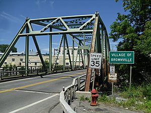
Entering the village of Brownville on Bridge Street
|
|
| Country | United States |
| State | New York |
| County | Jefferson |
| Town | Brownville |
| Area | |
| • Total | 0.64 sq mi (1.65 km2) |
| • Land | 0.62 sq mi (1.62 km2) |
| • Water | 0.01 sq mi (0.03 km2) |
| Elevation | 348 ft (106 m) |
| Population
(2020)
|
|
| • Total | 930 |
| • Density | 1,490.38/sq mi (575.53/km2) |
| Time zone | UTC-5 (Eastern (EST)) |
| • Summer (DST) | UTC-4 (EDT) |
| ZIP code |
13615
|
| Area code(s) | 315 |
| FIPS code | 36-10231 |
| GNIS feature ID | 0944965 |
Brownville is a small village located in Jefferson County, New York, United States. It is a part of the larger town of Brownville. In 2020, about 930 people lived here. The village got its name from Jacob Brown, who was one of the first people to settle and develop the area.
Brownville is found in the southern part of the town of Brownville. It is located to the west of the city of Watertown.
Contents
History of Brownville
The area where Brownville village now stands was first settled in 1799. This makes it one of the oldest settlements in the town. The village officially became a village in 1828. This means it got its own local government.
Geography of Brownville
Brownville is located in the middle of Jefferson County. Its southern edge is the Black River. This river also forms the border with the town of Hounsfield. To the east, Brownville is next to the village of Glen Park.
The village covers a total area of about 1.65 square kilometers (0.64 square miles). Most of this area is land. Only a very small part, about 0.03 square kilometers (0.01 square miles), is water.
Brownville is connected by important roads. These include New York State Route 12E and County Route 53. Route 12E goes east about 5 miles to Watertown. It also goes northwest about 8 miles to Chaumont.
Population of Brownville
| Historical population | |||
|---|---|---|---|
| Census | Pop. | %± | |
| 1810 | 400 | — | |
| 1840 | 1,000 | — | |
| 1850 | 900 | −10.0% | |
| 1860 | 621 | −31.0% | |
| 1870 | 450 | −27.5% | |
| 1880 | 409 | −9.1% | |
| 1890 | 666 | 62.8% | |
| 1900 | 767 | 15.2% | |
| 1910 | 854 | 11.3% | |
| 1920 | 976 | 14.3% | |
| 1930 | 842 | −13.7% | |
| 1940 | 907 | 7.7% | |
| 1950 | 1,013 | 11.7% | |
| 1960 | 1,082 | 6.8% | |
| 1970 | 1,187 | 9.7% | |
| 1980 | 1,099 | −7.4% | |
| 1990 | 1,138 | 3.5% | |
| 2000 | 1,022 | −10.2% | |
| 2010 | 1,119 | 9.5% | |
| 2020 | 930 | −16.9% | |
| U.S. Decennial Census | |||
In 2000, there were 1,022 people living in Brownville. By 2010, the population grew to 1,119 people. However, in the 2020 census, the population was 930 people.
In 2000, there were 419 homes in the village. About 32.5% of these homes had children under 18 living there. The average household had about 2.44 people. The average family had about 2.94 people. The median age of people in the village was 40 years old.
Education in Brownville
Students in Brownville attend schools in the General Brown Central School District. This district serves the educational needs of the community.
See also
 In Spanish: Brownville (villa) para niños
 | Delilah Pierce |
 | Gordon Parks |
 | Augusta Savage |
 | Charles Ethan Porter |


