
Bulloo Downs, Queensland facts for kids
Quick facts for kids Bulloo DownsQueensland |
|||||||||||||||
|---|---|---|---|---|---|---|---|---|---|---|---|---|---|---|---|
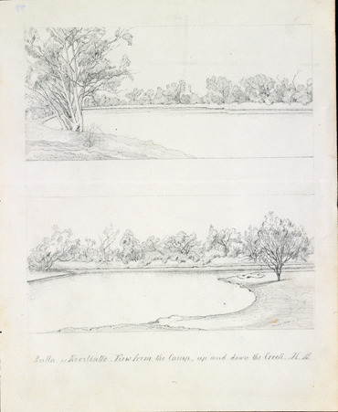
Sketch of Bulloo River area near the Kooliatto Waterhole, 1861 by Hermman Beckler, member of the Burke and Wills expedition
|
|||||||||||||||

Bulloo Downs
Location in Queensland
|
|||||||||||||||
| Population | 0 (2021 census) | ||||||||||||||
| • Density | 0/km2 (0/sq mi) | ||||||||||||||
| Postcode(s) | 4492 | ||||||||||||||
| Area | 11,252.1 km2 (4,344.5 sq mi) | ||||||||||||||
| Time zone | AEST (UTC+10:00) | ||||||||||||||
| Location |
|
||||||||||||||
| LGA(s) | Shire of Bulloo | ||||||||||||||
| State electorate(s) | Warrego | ||||||||||||||
| Federal Division(s) | Maranoa | ||||||||||||||
|
|||||||||||||||
Bulloo Downs is a quiet, mostly empty area in the countryside of Queensland, Australia. It's right on the border with New South Wales. Not many people live here; in fact, the 2021 census showed it had almost no residents.
In 2020, the Queensland Government changed the boundaries of some areas in the Shire of Bulloo. Bulloo Downs became a bit smaller, giving some land to Cameron Corner. It also gained a small piece of land from another area called Bullawarra. Its size changed from about 12,814 square kilometres to 11,252 square kilometres.
Contents
History of Bulloo Downs
Early Explorers and Settlers
In 1861, a group from the famous Burke and Wills expedition camped in Bulloo Downs. Sadly, three men from this group died and were buried there. This expedition helped people learn if the land was good for raising animals like sheep or cattle.
The first official settlement, called Bulloo Downs Station, was started in 1864. It was set up by three men named Jones, Sullivan, and Molesworth Green. The area gets its name from this station. The word Bulloo comes from the Kamilaroi language of the Aboriginal people, and it means slow.
Changing Borders
On April 17, 2020, the Queensland Government made some changes to the nine different areas, or "localities," in the Shire of Bulloo. They reorganised them into six localities. As part of this change, Bulloo Downs gave up a small part of its land in the west to the area known as Cameron Corner. However, it also gained a small piece of land from the southern part of what used to be called Bullawarra. The rest of Bullawarra became part of Thargomindah.
Who Lives in Bulloo Downs?
Bulloo Downs is a very quiet place. In both the 2016 and 2021 Australian censuses, it was recorded as having "no people or a very low population." This means almost no one lives there.
Special Places in Bulloo Downs
Bulloo Downs has some important historical sites. These are places that are protected because they have special meaning. One of these is:
