
Burg, Aargau facts for kids
Quick facts for kids
Burg
|
||
|---|---|---|
 |
||
|
||

Burg
Location in Switzerland

Burg
Location in Canton of Aargau
|
||
| Country | Switzerland | |
| Canton | Aargau | |
| District | Kulm | |
| Area | ||
| • Total | 0.94 km2 (0.36 sq mi) | |
| Elevation | 622 m (2,041 ft) | |
| Population
(December 2020)
|
||
| • Total | 1,033 | |
| • Density | 1,099/km2 (2,846/sq mi) | |
| Postal code |
5736
|
|
| Surrounded by | Menziken, Rickenbach (LU) | |

Burg was once a small town, or "municipality," in Switzerland. It was located in the Kulm district, within the canton of Aargau. On January 1, 2023, Burg joined with the nearby town of Menziken. Now, it is part of the Menziken municipality.
Contents
History of Burg: A Look Back
The name "Burg" comes from a castle called Unter-Rinach Castle. This castle was likely built in the 1100s. It was the home of the lords of Rinach. These lords were "vassals," meaning they served the powerful Habsburgs family.
Sadly, the castle was destroyed in 1386 during the Battle of Sempach. This battle was between the Habsburgs and the Old Swiss Confederacy, which was a group of early Swiss states. The castle was never rebuilt after that.
The first time Burg was mentioned in writing was in 1412. Records spoke of two farms "by the castle." By 1400, the rights to the land were shared. They were split between the Teutonic Order (a religious and military group) and the family of the "Schultheiss" of Lenzburg. A Schultheiss was like a mayor or chief official.
From 1415 to 1798, the city of Bern ruled Burg. Burg was part of Bern's Lenzburg district and the court of Reinach.
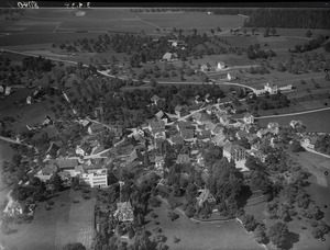
Geography of Burg: Where It Was Located
_155.jpg)
In 2009, Burg covered an area of about 0.94 square kilometers (0.36 square miles). A large part of this land, about 42.6%, was used for farming. Forests covered about 22.3% of the area.
About 33% of Burg's land was developed with buildings or roads. This settled area included industrial buildings (2.1%), homes (26.6%), and roads (4.3%). Nearly one-fifth of the land was thick forest.
Burg was located in the Kulm district. It sat on the eastern slopes of the Stierenberg mountain. It was almost completely surrounded by the town of Menziken.
Coat of Arms: The Symbol of Burg
The official design of Burg's town symbol, called its "coat of arms," was very clear. It showed a black castle with a tower on the right side. This castle stood on a green base, and there was a green pine tree next to it. The background was silver.
This design is an example of "canting arms." This means the picture on the coat of arms helps explain the name. "Burg" means "castle" in German, so having a castle on the flag makes sense!
People of Burg: Demographics
As of December 2018, Burg had a population of 1,060 people. In June 2009, about 30.9% of the people living there were from other countries. Over ten years (1997–2007), the population of Burg got a little smaller, by about 8.3%.
Most people in Burg (81.8%) spoke German in 2000. Italian was the second most common language (4.8%), followed by Turkish (4.2%).
Here's how the population was divided by age in 2008:
- Children (0-9 years old): 8.5%
- Teenagers (10-19 years old): 12.9%
- Young adults (20-29 years old): 17.0%
- Adults (30-39 years old): 11.6%
- Adults (40-49 years old): 17.8%
- Adults (50-59 years old): 14.7%
- Seniors (60-69 years old): 8.6%
- Seniors (70-79 years old): 5.9%
- Seniors (80-89 years old): 2.4%
- Seniors (90 and older): 0.5%
In 2000, the average home had 2.45 people living in it. About 53.3% of homes were "owner-occupied." This means the people living there owned their home, rather than renting it. They might have had a mortgage (a loan to buy a house) or a rent-to-own agreement.
_lernejo_157.jpg)
Swiss people are generally well-educated. In Burg, about 57.5% of adults (aged 25 to 64) had finished high school or gone on to higher education, like university. In the 2008/2009 school year, 67 students attended primary school in Burg.
Here's a look at how Burg's population changed over time:
| Historical population | ||
|---|---|---|
| Year | Pop. | ±% |
| 1764 | 154 | — |
| 1850 | 463 | +200.6% |
| 1900 | 563 | +21.6% |
| 1950 | 883 | +56.8% |
| 1990 | 1,142 | +29.3% |
| 2000 | 991 | −13.2% |
Economy of Burg: How People Worked
In 2007, Burg had a low unemployment rate of 2.53%. This means most people who wanted to work had jobs.
In 2005, there were different types of businesses in Burg:
- Primary sector: This includes jobs like farming. There were 2 businesses with 10 people working in this area.
- Secondary sector: This includes jobs like manufacturing or building things. There were 8 businesses with 135 people working in this area.
- Tertiary sector: This includes service jobs, like shops or offices. There were 11 businesses with 37 people working in this area.
In 2000, 486 people who lived in Burg had jobs. Most of them (about 85%) worked outside of Burg. However, 137 people traveled into Burg for work. There were 210 jobs available in Burg itself. About 8.2% of working people used public transportation to get to work. Most people (56.8%) used a private car.
Religion in Burg
Based on the 2000 census, about 27.9% of the people in Burg were Roman Catholic. About 42.9% belonged to the Swiss Reformed Church.
See also
 In Spanish: Burg (Argovia) para niños
