Burlington, Ohio facts for kids
Quick facts for kids
Burlington, Ohio
|
|
|---|---|

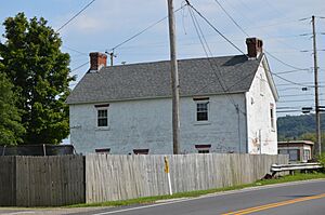
William C. Johnston House
|
|

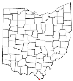
Location of Burlington, Ohio
|
|
| Country | United States |
| State | Ohio |
| County | Lawrence |
| Township | Fayette |
| Area | |
| • Total | 1.42 sq mi (3.67 km2) |
| • Land | 1.39 sq mi (3.61 km2) |
| • Water | 0.02 sq mi (0.06 km2) |
| Elevation | 554 ft (169 m) |
| Population
(2020)
|
|
| • Total | 2,416 |
| • Density | 1,733.14/sq mi (669.34/km2) |
| Time zone | UTC-5 (Eastern (EST)) |
| • Summer (DST) | UTC-4 (EDT) |
| ZIP Code |
45680 (South Point)
|
| FIPS code | 39-10352 |
| GNIS feature ID | 2393357 |
Burlington is a small community in Lawrence County, Ohio, United States. It sits right along the Ohio River. In 2020, about 2,416 people lived here.
Burlington is part of the larger Huntington–Ashland metropolitan area. It is connected to Huntington, West Virginia, by the West Huntington Bridge over the Ohio River. Burlington was once a very important place in Lawrence County. It was the first county seat (like a main town for the county's government) and had the county's first post office.
Did you know that a book series by David Baldacci features Burlington? The main character, Amos Decker, is from here. There are seven books in this exciting series!
Contents
Burlington's Past: A Look Back in Time
Burlington has a rich history. Starting in 1817, it served as the first county seat for Lawrence County. This meant it was the center for local government. It also had the only post office in the county until 1821.
The town got its name from Burlington, Vermont. This shows a connection to other places in the United States.
Several historic spots in Burlington are listed on the National Register of Historic Places. This list helps protect important buildings and sites. These include the Burlington 37 Cemetery, the William C. Johnston House and General Store, and the Old Lawrence County Jail. The nearby Macedonia Church is also on this list.
Where is Burlington Located?
Burlington is found in the southern part of Lawrence County, Ohio. It covers an area of about 1.4 square miles (3.6 square kilometers). All of this area is land.
The southern edge of Burlington is along the northern shore of the Ohio River. To the north, you'll find U.S. Route 52. The village of South Point, Ohio is to the west. To the east, Burlington borders Sybene, Ohio.
Even though South Point often says it's the southernmost point in Ohio, Burlington actually has a spot that is a tiny bit farther south!
Neighboring Communities Around Burlington
Burlington is located in Fayette Township, Lawrence County, Ohio. It shares borders or is close to several other communities:
- Huntington, West Virginia is to the southeast, just across the Ohio River.
- Ceredo, West Virginia is to the southwest, also across the Ohio River.
- South Point, Ohio is directly to the west.
Other nearby places include Union Township, Lawrence County, Ohio and the village of Chesapeake, Ohio, which are a short distance upstream (east). Perry Township, Lawrence County, Ohio is a short distance downstream (northwest).
Education in Burlington
Students in Burlington attend schools within the South Point Local School District. Burlington has its own elementary school, called Burlington Elementary School. Older students go to South Point Middle School and South Point High School, which are in the neighboring community of South Point.
Getting Around: Transportation
U.S. Route 52 is a main road that runs through the northern part of Burlington.
For air travel, there are two local airports. The Tri-State Airport serves the Huntington area. The Lawrence County Airpark is located right at the eastern edge of Burlington.
See also
 In Spanish: Burlington (Ohio) para niños
 | William L. Dawson |
 | W. E. B. Du Bois |
 | Harry Belafonte |

