Burrinjuck, New South Wales facts for kids
Quick facts for kids BurrinjuckNew South Wales |
|||||||||||||||
|---|---|---|---|---|---|---|---|---|---|---|---|---|---|---|---|
| Population | 19 (2016 census) | ||||||||||||||
| Postcode(s) | 2582 | ||||||||||||||
| Elevation | 574 m (1,883 ft) | ||||||||||||||
| Location |
|
||||||||||||||
| LGA(s) | Yass Valley | ||||||||||||||
| County | Harden | ||||||||||||||
| Parish | Childowla | ||||||||||||||
| State electorate(s) | Goulburn | ||||||||||||||
| Federal Division(s) | Eden-Monaro | ||||||||||||||
|
|||||||||||||||
|
|||||||||||||||
Burrinjuck is a small village in New South Wales, Australia. It's located in a region called the Riverina, known for its rivers and farming. The name "Burrinjuck" comes from an Aboriginal word. It means 'mountain with a rugged top'. In 2016, only 19 people lived there.
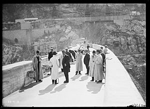
The village sits on the western side of the famous Burrinjuck Dam. This huge dam holds water from the Murrumbidgee River. It was built between 1907 and 1928. Building the dam took a long time because World War I caused delays.
Before the dam was full, there was a town called 'Barren Jack City'. It was right next to the river. But as the dam filled up, much of this old town disappeared under the water.
Interestingly, Burrinjuck was once considered as a possible spot for Australia's capital city! This proposed capital was called Mahkoolma. It was planned to be near Carrolls Creek.
The local post office opened in 1907 as Barren Jack Post Office. It was renamed Burrinjuck in 1911. The post office closed its doors in 1979.
Important Historic Places
Burrinjuck has several places that are listed for their historical importance. These are special sites that are protected because they tell us about the past.
Weather in Burrinjuck
Burrinjuck is located on the western slopes of the Brindabella Range. This means it gets a lot of rain, especially in winter.
Even though snow is rare in the valley itself, it snows every year on the hills and mountains around Burrinjuck. These higher areas are above 700 metres. For example, nearby Black Andrew Mountain (935 metres) and Mount Barren Jack (972 metres) can get snow-capped in winter.
| Climate data for Burrinjuck Dam (1908–2023, extremes 1965–2023); 390 m AMSL; 35.00° S, 148.60° E | |||||||||||||
|---|---|---|---|---|---|---|---|---|---|---|---|---|---|
| Month | Jan | Feb | Mar | Apr | May | Jun | Jul | Aug | Sep | Oct | Nov | Dec | Year |
| Record high °C (°F) | 45.6 (114.1) |
44.3 (111.7) |
39.0 (102.2) |
34.0 (93.2) |
29.0 (84.2) |
21.5 (70.7) |
20.6 (69.1) |
24.5 (76.1) |
30.0 (86.0) |
34.0 (93.2) |
39.4 (102.9) |
42.1 (107.8) |
45.6 (114.1) |
| Mean daily maximum °C (°F) | 29.8 (85.6) |
29.0 (84.2) |
26.1 (79.0) |
21.1 (70.0) |
16.2 (61.2) |
12.5 (54.5) |
11.7 (53.1) |
13.5 (56.3) |
16.9 (62.4) |
20.5 (68.9) |
24.0 (75.2) |
27.7 (81.9) |
20.7 (69.4) |
| Mean daily minimum °C (°F) | 15.6 (60.1) |
15.7 (60.3) |
13.4 (56.1) |
9.6 (49.3) |
6.4 (43.5) |
4.2 (39.6) |
3.0 (37.4) |
3.7 (38.7) |
5.6 (42.1) |
8.4 (47.1) |
11.1 (52.0) |
13.7 (56.7) |
9.2 (48.6) |
| Record low °C (°F) | 5.9 (42.6) |
7.0 (44.6) |
3.1 (37.6) |
0.9 (33.6) |
−0.7 (30.7) |
−3.8 (25.2) |
−7.0 (19.4) |
−4.0 (24.8) |
−6.1 (21.0) |
0.5 (32.9) |
2.6 (36.7) |
4.7 (40.5) |
−7.0 (19.4) |
| Average precipitation mm (inches) | 63.1 (2.48) |
56.1 (2.21) |
62.5 (2.46) |
64.7 (2.55) |
79.8 (3.14) |
96.0 (3.78) |
100.1 (3.94) |
97.7 (3.85) |
83.4 (3.28) |
85.5 (3.37) |
74.3 (2.93) |
63.1 (2.48) |
926.6 (36.48) |
| Average precipitation days (≥ 0.2 mm) | 6.5 | 5.7 | 6.3 | 6.9 | 9.3 | 12.0 | 13.2 | 13.4 | 10.9 | 10.3 | 8.6 | 7.4 | 110.5 |
| Source: Australian Bureau of Meteorology; Burrinjuck Dam | |||||||||||||
| Climate data for Billapaloola State Forest (1938–1969); 808 m AMSL; 35.27° S, 148.38° E | |||||||||||||
|---|---|---|---|---|---|---|---|---|---|---|---|---|---|
| Month | Jan | Feb | Mar | Apr | May | Jun | Jul | Aug | Sep | Oct | Nov | Dec | Year |
| Mean daily maximum °C (°F) | 26.6 (79.9) |
25.6 (78.1) |
23.1 (73.6) |
17.1 (62.8) |
12.6 (54.7) |
9.3 (48.7) |
8.4 (47.1) |
9.8 (49.6) |
13.8 (56.8) |
16.6 (61.9) |
20.0 (68.0) |
24.3 (75.7) |
17.3 (63.1) |
| Mean daily minimum °C (°F) | 12.1 (53.8) |
11.8 (53.2) |
9.8 (49.6) |
5.8 (42.4) |
3.2 (37.8) |
1.2 (34.2) |
0.1 (32.2) |
0.5 (32.9) |
2.4 (36.3) |
4.8 (40.6) |
7.2 (45.0) |
10.0 (50.0) |
5.7 (42.3) |
| Average precipitation mm (inches) | 86.9 (3.42) |
71.4 (2.81) |
98.8 (3.89) |
113.7 (4.48) |
163.4 (6.43) |
156.1 (6.15) |
172.6 (6.80) |
162.9 (6.41) |
132.6 (5.22) |
145.0 (5.71) |
120.1 (4.73) |
86.5 (3.41) |
1,516.8 (59.72) |
| Average precipitation days (≥ 0.2 mm) | 5.8 | 5.6 | 6.1 | 7.9 | 10.9 | 12.3 | 13.4 | 13.6 | 10.3 | 11.1 | 8.7 | 7.0 | 112.7 |
| Source: Australian Bureau of Meteorology; Billapaloola State Forest | |||||||||||||
 | Leon Lynch |
 | Milton P. Webster |
 | Ferdinand Smith |


