Butte Falls, Oregon facts for kids
Quick facts for kids
Butte Falls, Oregon
|
|
|---|---|

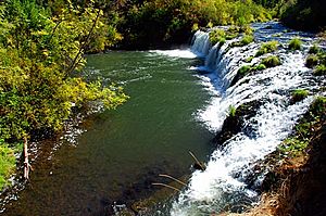
Big Butte Creek Falls, the city's namesake, located on the South Fork of Big Butte Creek
|
|

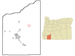
Location in Oregon
|
|
| Country | United States |
| State | Oregon |
| County | Jackson |
| Incorporated | 1911 |
| Area | |
| • Total | 0.43 sq mi (1.11 km2) |
| • Land | 0.43 sq mi (1.11 km2) |
| • Water | 0.00 sq mi (0.00 km2) |
| Elevation | 2,536 ft (772.97 m) |
| Population
(2020)
|
|
| • Total | 443 |
| • Density | 1,035.05/sq mi (399.66/km2) |
| Time zone | UTC-8 (Pacific) |
| • Summer (DST) | UTC-7 (Pacific) |
| ZIP code |
97522
|
| Area code(s) | 541 |
| FIPS code | 41-10050 |
| GNIS feature ID | 1139061 |
Butte Falls is a small city in Jackson County, Oregon, United States. It is located in the beautiful state of Oregon. In 2010, about 423 people lived there. By 2018, the number of people was thought to be around 450.
Contents
History of Butte Falls
Butte Falls became an official city in 1911. This means it got its own local government. A special map from 1927, called a Sanborn Fire Insurance Map, shows many of the first buildings in the town. Some of these old buildings are still used today.
Geography and Climate
Where is Butte Falls Located?
Butte Falls is a small town. The United States Census Bureau says it covers about 0.41 square miles (1.1 square kilometers). All of this area is land, with no large bodies of water inside the city limits.
What is the Weather Like?
Butte Falls has a type of weather called a warm-summer Mediterranean climate. This means the summers are warm and dry. The temperatures do not get extremely hot. Winters are usually mild and wet. This climate is often shown as "Csb" on climate maps.
People of Butte Falls
| Historical population | |||
|---|---|---|---|
| Census | Pop. | %± | |
| 1920 | 166 | — | |
| 1930 | 298 | 79.5% | |
| 1940 | 339 | 13.8% | |
| 1950 | 372 | 9.7% | |
| 1960 | 384 | 3.2% | |
| 1970 | 358 | −6.8% | |
| 1980 | 428 | 19.6% | |
| 1990 | 252 | −41.1% | |
| 2000 | 438 | 73.8% | |
| 2010 | 423 | −3.4% | |
| 2020 | 443 | 4.7% | |
| U.S. Decennial Census | |||
Population in 2010
In 2010, a census counted 423 people living in Butte Falls. These people lived in 166 homes, and 112 of these were families. The city had about 1031 people per square mile.
Most people in Butte Falls were White (95.7%). A small number were Native American or Asian. About 2.4% of the people were Hispanic or Latino.
Who Lives in Butte Falls?
- About 32.5% of homes had children under 18 years old.
- Many homes (45.8%) were married couples living together.
- Some homes had a single parent.
- About 25.9% of homes were people living alone.
- The average age of people in Butte Falls was 43.1 years old.
- About 22.7% of residents were under 18.
- About 13.5% of residents were 65 years or older.
- There were slightly more males (52.5%) than females (47.5%) in the city.
See also
 In Spanish: Butte Falls para niños

