
Big Butte Creek facts for kids
Quick facts for kids Big Butte Creek |
|
|---|---|

Willow Lake (located in the Big Butte Creek watershed), with Mount McLoughlin in the background
|
|

Location of the mouth of Big Butte Creek in Oregon
|
|
| Country | United States |
| State | Oregon |
| County | Jackson County |
| Physical characteristics | |
| Main source | Near Butte Falls Cascade Range, Jackson County, Oregon 2,244 ft (684 m) 42°33′30″N 122°34′38″W / 42.55833°N 122.57722°W |
| River mouth | Rogue River about 1 mile (1.6 km) southwest of Lost Creek Dam, Jackson County, Oregon 1,562 ft (476 m) 42°39′27″N 122°41′37″W / 42.65750°N 122.69361°W |
| Length | 12 mi (19 km) |
| Basin features | |
| Basin size | 245 sq mi (630 km2) |
Big Butte Creek is a 12-mile (19 km) long tributary of the Rogue River in Oregon, a state in the United States. It helps drain about 245 square miles (630 km²) of land in Jackson County.
The creek has two main parts, called forks: the North Fork and the South Fork. Both start high up in the Cascade Range mountains, close to Mount McLoughlin. They flow mostly west and meet near the town of Butte Falls. From there, the main part of the creek flows northwest until it joins the Rogue River.
Long ago, over 8,000 years ago, Native American tribes like the Klamath, Upper Umpqua, and Takelma lived in the Big Butte Creek area. In the 1850s, during the Rogue River Wars, many Native Americans were moved to Indian reservations. The first non-Native settlers arrived in the 1860s. They named the creek after Snowy Butte, which is an old name for Mount McLoughlin. In the late 1800s, people mostly used the land for farming and cutting down trees. Butte Falls became an official town in 1911. It is still the only town in the creek's watershed.
Big Butte Springs, which is in the watershed, provides clean drinking water for over 115,000 people in the Rogue Valley. It produces more than 26 million US gallons (98,000,000 L) of water every day. Water from Big Butte Creek is also used to water crops in other places.
The water in the Big Butte Creek watershed is usually very clean. It is home to several kinds of trout and salmon. The area also has over 152 types of birds, 63 types of mammals, 19 types of reptiles, and many plants. In 1995, the Poverty Flats area was named an Area of Critical Environmental Concern to help protect some rare plants.
Contents
What is Big Butte Creek's Path?
Big Butte Creek starts in the Cascade Range mountains near Butte Falls. It flows generally northwest for about 12 miles (19 km) until it meets the Rogue River. The North Fork and South Fork of Big Butte Creek join together at about 2,244 feet (684 m) above sea level. The creek's mouth, where it enters the Rogue River, is at an elevation of 1,562 feet (476 m).
North Fork's Journey
The North Fork starts on the slopes of Rustler Peak, which is 6,207 feet (1,892 m) tall. It flows southwest and gets water from many smaller streams like Jackass, Eighty Acre, and Friese creeks. Then it turns west, flowing just north of Butte Falls before it meets the South Fork.
South Fork's Journey
The South Fork begins where two of its own streams, Twincheria and Rancheria creeks, meet. It flows southwest and gets water from Fourbit Creek on its left side. Fourbit Creek starts near Mount McLoughlin. It is thought that water might seep into it from nearby Fourmile Lake. The South Fork then turns west and receives Willow Creek on its left.
Big Butte Springs are located on Willow Creek. The Medford Aqueduct, a pipeline that carries drinking water to cities in the Rogue Valley, runs alongside the South Fork from there to Butte Falls. The South Fork flows over the 15-foot (4.6 m) tall Butte Falls, which is how the nearby city got its name. It then joins the North Fork about 1 mile (1.6 km) downstream.
Main Creek's Path
After the forks join, Big Butte Creek flows northwest. It collects water from McNeil Creek on the left and Clark Creek on the right, plus many other small streams. This part of the creek has many Class II and III rapids, which are rated on the International Scale of River Difficulty.
Roads cross the stream at a few points. About 0.6 miles (1.0 km) before it ends, Big Butte Creek flows over Crowfoot Falls. It then empties into the Rogue River, which is about 155 miles (249 km) from the Pacific Ocean. The mouth of Big Butte Creek is about one mile southwest of William L. Jess Dam. Oregon Route 62 passes just north of it.
How Much Water Flows?
The United States Geological Survey (USGS) measures how much water flows in Big Butte Creek. They have three measuring stations: two on the South Fork and one near the main creek's mouth. The South Fork stations stopped working in 1991, but the station near the mouth of Big Butte Creek is still active. In summer, the main creek often has less water than the South Fork alone. This is because water is taken out for other uses.
| Stream | Location | Area Drained | Years Recorded | Average Flow | Highest Flow | Lowest Flow |
|---|---|---|---|---|---|---|
| South Fork | above Willow Creek | 67.6 sq mi (175 km2) | 1986–1991 | 61.4 cu ft/s (1.74 m3/s) | 662 cu ft/s (18.7 m3/s) (February 23, 1986) |
21 cu ft/s (0.59 m3/s) (August–September 1988, September 1990) |
| South Fork | near Butte Falls | 138 sq mi (357 km2) | 1911–1991 | 151 cu ft/s (4.28 m3/s) | 12,600 cu ft/s (357 m3/s) (December 22, 1964) |
31 cu ft/s (0.88 m3/s) (September 1981) |
| Main stem | near mouth | 245 sq mi (635 km2) | 1945–Present | 244 cu ft/s (6.91 m3/s) | 16,800 cu ft/s (476 m3/s) (December 22, 1964) |
6.4 cu ft/s (0.18 m3/s) (June 23–24, 1977) |
What is the Big Butte Creek Watershed Like?

The Big Butte Creek watershed covers about 245 square miles (630 km²) in southern Oregon. The land ranges from 1,562 feet (476 m) high at the creek's mouth to 9,495 feet (2,894 m) at the top of Mount McLoughlin. The average height is 3,528 feet (1,075 m). About 56% of the land is owned by the government (like the Bureau of Land Management and the United States Forest Service). 44% is privately owned, and a small part belongs to the City of Medford.
The Big Butte Creek watershed has a Mediterranean climate. This means it has hot, dry summers and mild, wet winters. Temperatures can range from 10 °F (−12 °C) in winter to 100 °F (38 °C) in summer. The area gets between 35 and 80 inches (890 and 2,000 mm) of rain and snow each year. Most of this falls between November and March. About 56% of the water that flows into the creek comes from melting snow.
The watershed has two main types of land, both formed by volcanoes: the High Cascades and the Western Cascades. The Western Cascades make up the western two-thirds of the watershed. This area is older, between 17 and 38 million years old, and has been worn down by weather. Its slopes are often unstable and made of volcanic ash and rock. Because these rocks absorb a lot of water, earthflows (slow-moving landslides) are common. The High Cascades are much younger, about three to seven million years old. Mount McLoughlin is the most famous volcano in this area. It last erupted between 20,000 and 15,000 years ago. The most common rocks here are basalt and andesite.
Animals and Plants of Big Butte Creek

Some common trees in the Big Butte Creek watershed include four types of fir trees, two types of pine trees, incense cedar, and western hemlock. Smaller plants that grow beneath the trees include Pacific yew, Pacific madrone, chinquapin, and vine maple.
Some plants that are not native to the area, like Kentucky bluegrass and drooping brome, have been found here. They likely spread because too many animals were grazing (eating plants) in the area. There are also rare plants like Howell's yampah and Egg Lake monkeyflower. The Poverty Flats Area of Critical Environmental Concern (ACEC) protects several rare plant species, including Bellinger's meadowfoam.
Over 152 kinds of birds are known to live in the Big Butte Creek watershed. These include the northern goshawk and the northern spotted owl, which is a species that needs protection. Bald eagles build their nests around Willow Lake.
Amphibians like the Oregon spotted frog and the Cascades frog also live in some parts of the watershed. The most common of the 63 types of mammals found here are Black-tailed deer, Roosevelt elk, cougars, and black bears. Fishers and American martens have also been seen. The gray wolf and the grizzly bear used to live here but are no longer found in the area. There are 19 types of reptiles. Other animals that need protection include the wolverine, the western pond turtle, and the sandhill crane.
Rainbow trout, chinook salmon, coho salmon, and Pacific Lamprey are common fish that swim up Big Butte Creek from the ocean. They can travel as far as Butte Falls. Because the water above Butte Falls is cold and it's hard for fish to jump over the waterfall, there are fewer of these fish there. Native fish that live in this area all the time include coastal cutthroat and rainbow trout. Willow Lake has largemouth bass and rainbow, cutthroat, and brook trout. In recent years, the total number of fish in the Big Butte Creek watershed has gone down. This might be because trees and plants along the creek have been removed, and water temperatures are rising.
A Look at Big Butte Creek's Past
_(jacDA0005a).jpg)
People have lived in the Big Butte Creek area for at least 8,000 years. Native American tribes like the Klamath, Upper Umpqua, Takelma, and Latgawa lived in the watershed. In the 1850s, during the Rogue River Wars, many Native Americans were moved to special areas. On December 24, 1855, a group of men attacked a Native American camp near the creek's mouth. Many Native Americans were killed or captured, and the camp was burned.
Non-Native settlers started arriving in the early 1860s. Soon, farming, ranching, and logging became important industries. Early settlers named Big Butte Creek because it was close to Mount McLoughlin, which was also called Snowy Butte.
In 1904, a sawmill that used water power was built at Butte Falls. The town of Butte Falls was started in 1906 and became an official town in 1911. A railway was built to Butte Falls in 1910. The town also got rights to use water from Ginger Springs for drinking.
In 1910, a large fire called the Cat Hill Burn destroyed 30,000 acres (120 km²) of forest on Rustler Peak. In 1915, the Eagle Point Irrigation Canal was built. It takes about 100 cubic feet per second (2.8 m³/s) of water from Big Butte Creek to water crops in the Little Butte Creek watershed. The Butte Falls Fish Hatchery was also built in 1915. It originally used water from Ginger Creek, but in 1923, a canal was built to bring water from the South Fork of Big Butte Creek.
The Medford Aqueduct, a 31-inch (79 cm) wide pipeline, was built in 1927. It carries about 40 cubic feet per second (1.1 m³/s) of drinking water from Big Butte Springs south to the Bear Creek watershed. In 1951, a second pipeline was added, and Willow Dam was built, creating Willow Lake. Today, these springs provide water to over 115,000 people in the Rogue Valley.
Many trees were cut down in the 1920s and 1930s. Efforts to plant new trees began in the 1940s because new trees weren't growing fast enough on their own. In 1962, a big storm called the Columbus Day Storm knocked down many more large trees. Today, only about five percent of the watershed is covered by very old, large trees (called old-growth forests).
In 1995, the Poverty Flats area was named an Area of Critical Environmental Concern (ACEC) by the Bureau of Land Management. This area, about 3.5 miles (5.6 km) west of Butte Falls, is home to several rare plants. It was fenced off in 1996 to protect it from cattle.
The Butte Falls Fish Hatchery was planned to close in 2009, but it stayed open with one employee. However, it finally closed for good in October 2010.
On October 2, 2011, a 160-foot (49 m) part of the Eagle Point Irrigation Canal broke. This sent 86 cubic feet per second (2.4 m³/s) of muddy water down a hillside and into lower Big Butte Creek, which is an important area for salmon to lay their eggs. A measuring station on the Rogue River reported that the water was twenty times muddier than usual. The canal was fixed by October 28.
How Clean is the Water?
The Oregon Department of Environmental Quality (DEQ) checks the water quality of Big Butte Creek. They look at things like temperature, how much oxygen is in the water, pH (how acidic or basic the water is), nutrients, bacteria, chemicals (like pesticides and metals), and how muddy the water is. If a stream doesn't meet the standards, it's put on a special list.
In 2004/2006, about 54.2 miles (87.2 km) of streams in the Big Butte Creek watershed were on this list. The entire main part of the creek had problems with temperature, oxygen, and E. coli (a type of bacteria). The lower 13.9 miles (22.4 km) of the North Fork also had high temperatures, as did many smaller streams. The South Fork itself was not on the list, but some of its smaller streams were.

Overall, the water quality in the Big Butte Creek watershed is usually good. However, building roads and cutting down trees can cause a lot of erosion. This means soil and dirt wash into the water, making it muddy. The Willow Creek area often gets muddy, but Willow Lake helps by trapping the mud before it flows further downstream. Big Butte Springs provides very clean water that doesn't need much treatment to be safe to drink. The water from the springs has very few chemicals, is not very muddy, and stays at a cool temperature, usually between 44 and 46 °F (7 and 8 °C).
Fun Things to Do
Many people enjoy outdoor activities in the Big Butte Creek watershed. These include hunting, camping, hiking, and horseback riding. Many visitors also come just to see the beautiful scenery.
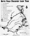
The Blue Canyon Trail is a very popular path in the area. It leads to the Sky Lakes Wilderness and eventually connects to the much longer Pacific Crest Trail. The town of Butte Falls has created the Butte Falls Discovery Loop Tour. This is a half-day drive through the Rogue River – Siskiyou National Forest. The loop starts in Butte Falls and has several stops where you can hike and enjoy views of the landscape, including Mount McLoughlin.
On Willow Lake, people enjoy boating, swimming, fishing, and waterskiing. Fishing is also popular in other streams, especially Fourbit Creek. In winter, Cross-country skiing and snowmobiling are popular activities.
Images for kids
-
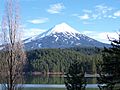
Willow Lake (located in the Big Butte Creek watershed), with Mount McLoughlin in the background
-
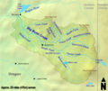
A map of the Big Butte Creek watershed
-
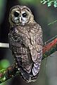
The northern spotted owl, a rare species that inhabits the watershed
-
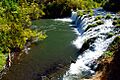
Butte Falls, located on the South Fork of Big Butte Creek
-
A map of the Butte Falls Discovery Loop Tour, which passes through scenic areas of the Rogue River – Siskiyou National Forest
See also
 In Spanish: Big Butte Creek para niños
