Cabin Run (Tohickon Creek tributary) facts for kids
Quick facts for kids Cabin Run |
|
|---|---|

|
|
| Country | United States |
| State | Pennsylvania |
| County | Bucks |
| Township | Bedminster, Plumstead |
| Physical characteristics | |
| Main source | 481 feet (147 m) 40°23′53″N 75°10′37″W / 40.39806°N 75.17694°W |
| River mouth | 263 feet (80 m) 40°25′57.7″N 75°6′39.5″W / 40.432694°N 75.110972°W |
| Length | 4.5 miles (7.2 km) |
| Basin features | |
| Progression | Cabin Run → Tohickon Creek → Delaware River → Delaware Bay |
| River system | Delaware River |
| Basin size | 6 square miles (16 km2) |
| Bridges | Kellers Church Road Pennsylvania Route 611 (Easton Road) Pennsylvania Route 413 (Durham Road) Wismer Road, Carversville Road |
| Slope | 4.5 feet per mile (0.85 m/km) |
Cabin Run is a small stream, also called a tributary, located in Bucks County, Pennsylvania. It begins in the southwestern part of Bedminster Township. The stream then flows into the Tohickon Creek in northeastern Plumstead Township. Cabin Run is about 4.5 miles (7.2 km) long.
Contents
History of Cabin Run
Cabin Run got its name from the many log cabins and stone houses built along its banks in the 1700s. You can find the stream on old maps from as far back as 1770.
Long ago, there were mills that used the stream's water to operate. These included the Leatherman grist mill, which ground grain, and sawmills that cut wood. There was also a cider mill.
Historic Covered Bridges
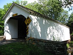
Two famous bridges cross Cabin Run: the Cabin Run Covered Bridge and the Loux Covered Bridge. These historic bridges were added to the National Register of Historic Places on December 1, 1980. This means they are important historical sites worth protecting.
Facts About Cabin Run
Cabin Run is part of a larger area called a watershed. A watershed is all the land where water drains into a specific stream or river. Cabin Run's watershed covers about 6.00 square miles (15.5 km2).
The stream flows into the Tohickon Creek about 4.50 river mile[convert: unknown unit] from the Tohickon's start.
Where Cabin Run Flows
Cabin Run starts from a small pond. This pond is located west of where Kellers Church Road and Scott Road meet in Bedminster Township. It's about 1.36 miles (2.19 km) northwest of Plumsteadville.
The stream generally flows towards the northeast. As it travels, four smaller unnamed streams join Cabin Run. Finally, Cabin Run meets the Tohickon Creek about 310 feet (94 m) northeast of the Cabin Run covered bridge.
What the Ground is Made Of
Cabin Run flows through an area with a specific type of rock called the Brunswick Formation. This area is part of the Appalachian Highlands Division in Pennsylvania.
The Brunswick Formation is mostly made of:
These rocks can also contain minerals like argillite and hornfels.
Bridges Over Cabin Run
Many roads and bridges cross over Cabin Run. Here are some of the main crossings:
| Crossing Name | Length | Lanes | Spans | Material/Design | Built Year |
|---|---|---|---|---|---|
| Kellers Church Road | 7.3 metres (24 ft) | - | - | Concrete culvert | 2006 |
| Pennsylvania Route 611 (Easton Road) | - | - | - | - | - |
| Pennsylvania Route 413 (Durham Road) | - | - | - | - | - |
| Wismer Road (south side), changes to Carversville Road (north side) at the Loux Covered Bridge | - | - | - | - | - |
| Covered Bridge Road (Cabin Run Covered Bridge) | 21 metres (69 ft) | 1 | 1 | Wood or Timber Truss - thru | - |
 | Mary Eliza Mahoney |
 | Susie King Taylor |
 | Ida Gray |
 | Eliza Ann Grier |


