
Cadbury Castle, Somerset facts for kids
 |
|

Location in Somerset
|
|
| Alternative name | Camalet |
|---|---|
| Location | Near South Cadbury and Yeovil, Somerset, England |
| Coordinates | 51°1′26.76″N 2°31′54.48″W / 51.0241000°N 2.5318000°W |
| Type | Hillfort |
| History | |
| Periods | Iron Age |
| Site notes | |
| Condition | Some damage |
Cadbury Castle, also known as Camalet, is an ancient hillfort in Somerset, England. It was built during the Bronze Age and Iron Age. Many people believe it is the legendary King Arthur's court, Camelot.
This hillfort sits on a large flat area of land, about the size of 10 football fields. This area is surrounded by strong walls of earth, called ramparts, on the sides of Cadbury Hill. Archaeologists have dug here many times, starting in the late 1800s. These digs have found tools and other items from people who lived there long ago. People lived and used this site from the Stone Age, through the Bronze and Iron Ages. Later, Roman soldiers used it, and then people lived there again from about 470 AD until after 580 AD. In the 11th century, it even had a temporary mint where coins were made. Digs have found remains of buildings, like a "Great Hall," round and square houses, metal workshops, and possibly small temples.
Contents
What are Hillforts?
Hillforts are large forts built on hills. They first appeared in Britain around 1000 BC. People built them for different reasons. Some think they were military bases to protect against invaders. Others believe they were built because more people meant less land for farming, leading to arguments.
Many experts now think that when people started using iron more, it changed society. Iron was found in different places than the metals used for bronze. This changed how people traded goods. Old leaders lost power, and new groups became important.
Archaeologist Barry Cunliffe suggests that hillforts offered protection when arguments among people turned into fights. He says they weren't always built because there was a war. But they were useful strongholds when tensions were high.
Where is Cadbury Castle?
Cadbury Castle is about 5 miles (8 km) northeast of Yeovil. It sits on top of Cadbury Hill, which is a limestone hill. The hill is on the edge of the flat Somerset Levels area. The very top of the hill is about 153 meters (502 feet) above sea level.
The hill is surrounded by several layers of earth banks and ditches. On the northwest and south sides, there are four ramparts. On the east side, there are two. The flat top of the hill is about 7.28 hectares (18 acres) wide. The inner bank around the top is 1.2 kilometers (0.75 miles) long. Another nearby area, called Sigwells, also has many ancient remains. Because of trees and bushes growing on the site, it is now on a list of "Heritage at Risk" places.
History of Cadbury Castle
Early Life on the Hill

The first signs of people living here are from the Stone Age. Archaeologists found pits and holes for posts, along with old pottery and flint tools. These show that a small farming village was here around 3500 to 3300 BC.
Later, during the Late Bronze Age, people also lived here. They found old ovens from this time. Digs have also uncovered a very special item: the first Bronze Age shield found in an excavation in northwest Europe! This shield is a special "Yetholm-type" shield. It was likely placed here around 1000 BC.
People continued to live on the hill throughout the Iron Age. Around 300 BC, a stone wall was built around the area. Over time, the simple square houses were replaced by roundhouses. Large ramparts and strong wooden defenses were built and made stronger over many years.
Archaeologists have found foundations of both round and rectangular houses. They also found evidence of metalworking and possibly small temples. Many items found during these digs are now on display at the Museum of Somerset in Taunton.
The Castle and Roman Times
Around the first century BC, more banks and ditches were added, making Cadbury Castle a very strong hillfort with many layers of defense.
There is evidence that the fort was attacked violently around 43 AD. The defenses were damaged even more later in the 1st century when the Roman army built a barracks on the hilltop. Digs have shown signs of severe fighting, with weapons and fire damage. Some historians believe this happened during the first Roman invasion of Britain, led by Vespasian. It seems the local tribes, the Durotriges and Dobunni, fought hard against the Roman army here. Later, in the late 200s and 300s AD, there was a lot of activity at the site, and a Roman-British temple might have been built.
After the Romans
After the Romans left Britain, people continued to use Cadbury Castle from about 470 AD until after 580 AD. Archaeologists found a large "Great Hall" here, about 20 by 10 meters (66 by 33 feet). The old Iron Age defenses were made strong again, making the site twice as big as any other known fort from that time.
They also found pieces of pottery from the eastern Mediterranean Sea. This shows that the people living at Cadbury Castle had trade links far away. It seems likely that this was the main fort for an important British ruler, his family, his warriors, and his servants.
Between 1010 and 1020 AD, the hill was used for a short time as a Saxon mint, making coins when the main mint in Ilchester couldn't.
Medieval Period
According to the Domesday Book, a very old record from 1086, Cadbury Castle was part of the land owned by a person named Turstin FitzRolf. There might have been some small building work on the site in the 13th century too.
Studying Cadbury Castle Today
Today, a project called the South Cadbury Environs Project continues to study the archaeology of the site and the area around it. Since 1992, this team, including local volunteers, has used modern methods like geophysical surveys (which look underground without digging) and test pits.
This project involves experts from several universities, including Bristol, Glasgow, Birmingham, and Oxford. They study the castle and the surrounding area up to 8 kilometers (5 miles) away to learn more about its long history.
Images for kids
-
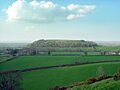
An aerial view of Cadbury Castle.
