
Cadder, Glasgow facts for kids
Quick facts for kids Cadder
|
|
|---|---|
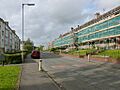
.jpg) Tenement housing in the process of refurbishment on Skirsa Street (2012) |
|

Cadder
|
|
| OS grid reference | NS577695 |
| Council area | |
| Country | Scotland |
| Sovereign state | United Kingdom |
| Post town | GLASGOW |
| Postcode district | G23 5 |
| Police | Strathclyde |
| Fire | Strathclyde |
| Ambulance | Scottish |
| EU Parliament | Scotland |
| UK Parliament | |
| Scottish Parliament | |
Cadder is a neighbourhood located in the north of Glasgow, Scotland. It's about 5 kilometers (3 miles) north of Glasgow city centre. This area sits right along the Forth and Clyde Canal, a famous waterway.
Cadder was built in the early 1950s. It stretches about 800 meters (875 yards) from east to west, but is only about 200 meters (218 yards) from north to south. It's on a fairly sloped piece of land. The neighbourhood is part of the Canal ward, which is a local area managed by Glasgow City Council. Historically, Cadder has been closely linked with the nearby areas of Lambhill and Maryhill.
What is Cadder Like?
Cadder has local shops on Skirsa Street and Cadder Road where people can buy everyday items. The area is home to Cadder Primary School and a nursery on Langa Street. There used to be another school, St. Agnes' RC Primary School, but it has now closed and new homes are built there.
The homes in Cadder are a mix of different types. You'll find three- and four-storey tenement buildings, which are large blocks of flats. There are also semi-detached houses, which are homes joined together in pairs. These homes are either privately owned or rented from the Cadder Housing Association, which has its office on Fara Street. The community also has a Community Centre on Tresta Road, where people can gather for activities. Many of the streets in Cadder are named after places in northern Scotland, like the Shetland Islands.
Don't Get Confused!
It's important not to mix up this Cadder with another place called Cadder that is part of Bishopbriggs. That other Cadder is about 3 miles (5 kilometers) to the north-east, also along the Forth and Clyde Canal. They share the same name but are different places!
Getting Around Cadder
Cadder has some transport options, though they are not as many as in nearby areas like Summerston. Local buses, run by First Glasgow, serve the area. You can catch the No. 7/7A and No. 8/8A buses here.
There is also a train station nearby on the Maryhill Line. This train line connects Glasgow Queen Street station to Anniesland. When the train line first opened in 1993, the station near Cadder was called "Lambhill". However, even though it was named after Lambhill, it was actually located on the western side of Cadder. In May 1998, the station was renamed Gilshochill railway station.
Images for kids
-
Tenement housing in the process of refurbishment on Skirsa Street (2012)
