
Caer Bach facts for kids

Caer Bach in its situation above the Conwy Valley
|
|

Location in Conwy
|
|
| Coordinates | 53°14′20″N 3°52′59″W / 53.23881469°N 3.88313994°W |
|---|---|
| Altitude | 413 m (1,355 ft) |
| Type | Hillfort |
| Diameter | 38 m (124 ft) Internal diameter |
| History | |
| Material | Stone, earth |
| Periods | Prehistoric |
| Site notes | |
| Condition | Rampart, good; Wall, robbed. |
| Management | Cadw |
| Public access | Yes |
Caer Bach is an ancient hillfort in North Wales. We don't know its exact age. It sits on a small, round hill near the village of Rowen in Conwy County.
Its name means 'Small Fort' or 'Little Fortress' in English. The fort is located on the eastern side of Tal-y-Fan. This is a smaller peak of the Carneddau mountain range in northeast Snowdonia. It is about 413 metres (1,355 feet) above sea level.
Not much is known about the fort's history. This is because it has not been explored very much yet. Caer Bach is a protected historical site. It is very important for helping us learn about how people lived long, long ago. Experts believe it still holds many hidden clues about the past.
Contents
What is Caer Bach Like?

Caer Bach is a small hillfort located about 1,300 feet above sea level. It sits on a small, rounded hill that sticks out from Tal-y-Fan. The fort has two main lines of defense that go around it.
The outer defense is a bank of earth with a ditch outside it. This bank is still about 10 feet tall. You can see parts of a stone wall on the outside of this bank. There is also a smaller bank on the south side. The eastern side of the fort blends into the natural hillside.
About 50 feet away from this outer defense, there are the remains of a stone wall. This inner wall was once very thick, about 12 to 15 feet wide. Many of its stones have been taken away over time. Where the wall still stands, you can see large stones placed on their long edges.
The entrances to both defenses were on the southeast side. However, they are now very ruined. Inside the fort, on the northwest side, you can still see the outline of an old hut.
Caer Bach is a type of fort that follows the shape of the land. It is unusual because it's not in the strongest defensive spot. It is also quite small. From the fort, you can see wide views over the Conwy valley. Some people think its location was important for an old path from ancient times. This path might have gone from the mouth of the River Conwy to a mountain pass called Bwlch-y-Ddeufaen. Since not much digging has happened here, we don't have clues about its exact age.
Other Ancient Sites Nearby

Just southwest of Caer Bach, there are the remains of a round hut. It is about 24 feet across and was built into the hillside. This hut dates back to the Iron Age or Roman period.
The Royal Commission on the Ancient and Historical Monuments of Wales has also noted three Bronze Age burial mounds near the fort. These mounds are made of earth and stones. They are in poor condition now. The tallest one is about 1 foot, 6 inches high and 18 feet wide.
How to Visit Caer Bach

Caer Bach is in a remote, hilly area. So, getting there means you will need to walk a bit over uneven ground.
One quick way to get there is to drive to Llangelynin church. You can take a narrow road through Henryd to reach it. There is a small car park there. From the car park, you can walk to the fort. Follow the public footpath that is part of the North Wales Pilgrims Way. It goes west past the church, then turns south towards the fort. The church is not on the Ordnance Survey map, but it is at reference SH751737.
Another way to visit is to park your car at Bwlch-y-Ddeufaen. From there, you can follow the old Roman road past Cae Coch farm. Then, leave the track and take the public footpath that goes northeast. This path leads right to the fort. This route will also take you very close to an ancient Bronze Age burial chamber called 'Maen-y-Bardd'.
Public footpaths lead to the site from all directions. The fort itself is near the southeastern edge of a large area of 'Open Common' land. This means you can walk freely there. You can find a map of this area here.
Other Prehistoric Sites Nearby
The area around Caer Bach is full of ancient remains. Here are a few other interesting sites nearby:
- (SH75427395) Cerrig-y-Ddinas: An Iron Age hillfort.
- (SH74067178) Maen-y-Bardd: A Neolithic burial chamber. It is thought to have been built around 3500 BC.
- (SH74127188) Burial Chamber, near Maen-y-Bardd.
- (SH73907357) Maen Penddu: A standing stone near Tal-y-Fan quarry.
- (SH71517177) Bronze Age standing stones & cairn at Bwlch-y-Ddeufaen.
- (SH72457132) Cerrig Pryfaid: A stone circle.
Images for kids
-
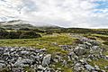
Remains of a stone wall at Caer Bach, looking NW towards the Eastern slopes of Tal-y-Fan.
