Calfpasture River facts for kids
Quick facts for kids Calfpasture River |
|
|---|---|

|
|
|
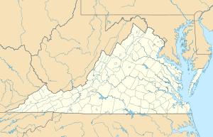
Location of the mouth of the Calfpasture River in Virginia
|
|
| Country | United States |
| State | Virginia |
| County | Rockbridge County, Augusta County |
| Physical characteristics | |
| Main source | Gordons Peak Allegheny Mountains, Augusta County, Virginia 3,460 ft (1,050 m) 38°20′32″N 79°18′15″W / 38.34222°N 79.30417°W |
| River mouth | Maury River Near Goshen, Rockbridge County, Virginia 1,345 ft (410 m) 37°56′57″N 79°27′34″W / 37.94917°N 79.45944°W |
| Length | 41 mi (66 km) |
| Basin features | |
| Basin size | 144 sq mi (370 km2) |
| Tributaries |
|
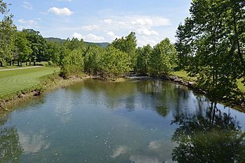
The Calfpasture River is a cool river located in the state of Virginia, United States. It travels about 41 miles (66 km) from where it begins at Gordons Peak in the Allegheny Mountains. The river then meets up with the Little Calfpasture River. Together, they form the Maury River.
From the Maury River, the water flows into the James River. Eventually, it reaches the Chesapeake Bay and then the huge Atlantic Ocean. Sometimes, people call the Calfpasture River by other names. These include Big Calfpasture River, Calf Pasture River, Great Calfpasture River, and North River.
Where the River Flows
The Calfpasture River starts high up on Gordons Peak. This peak is in Augusta County, close to Shenandoah Mountain. The river's very first streams come from Bald Ridge. These areas are part of the George Washington National Forest.
Journey Through Valleys
For most of its trip, the river flows towards the southwest. A smaller stream called Braley Branch joins it early on. This happens just before the river passes by a small town called West Augusta. You can see U.S. Route 250 crossing the river right there.
As the river keeps going southwest, another stream, West Dry Branch, adds its water. Then, the Calfpasture River enters Deerfield Valley. Here, two more streams, Tizzle Branch and Still Run, join in. Deerfield Valley is a pretty area. It has Shenandoah Mountain on one side and Great North Mountain on the other.
The river then flows past a tiny town called Little Baltimore. After that, one of its main helper streams, Hamilton Branch, connects with it. The Calfpasture River then leaves Deerfield Valley. It flows through a spot called Fridley Cove, where Fridley Branch joins.
Reaching Rockbridge County
After Fridley Cove, the Calfpasture River continues its journey southwest. It moves through a valley between Walker Mountain and Great North Mountain. The river passes by a small town called Marble Valley. Then, Clayton Mill Creek joins in. This is where the river leaves Augusta County and enters Rockbridge County.
Near the town of Goshen, the Calfpasture River gets more water. Mill Creek joins from the west, and Goshen Branch joins from the east. State Route 42 crosses the river in Goshen. Also, State Route 39 follows the river downstream from Goshen.
Just south of Goshen, a stream called Brattons Run joins the Calfpasture River. The river then makes a turn towards the east. It flows through a gap between Bratton Mountain and Knob Mountain. Finally, the Calfpasture River meets the Little Calfpasture River. When these two rivers come together, they officially form the Maury River.
 | Delilah Pierce |
 | Gordon Parks |
 | Augusta Savage |
 | Charles Ethan Porter |


